بورن، لینکلنشر
| Bourne | |
|---|---|
 Bourne town centre | |
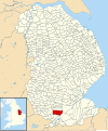
 Bourne Location within | |
| جمعیت | ۱۳٬۹۶۱ [۱] |
| OS grid reference | TF094202 |
| • لندن | ۹۰ mi (۱۴۰ km)* S |
| Civil parish |
|
| District |
|
| Shire county |
|
| Region |
|
| اؤلکه | England |
| موستقیل دوولت | United Kingdom |
| Post town | BOURNE |
| Postcode district | PE10 |
| تیلفون کودو | 01778 |
| UK Parliament |
|
بورن، لینکلنشر (اینگیلیسیجه: Bourne, Lincolnshire) بریتانیادا بیر یاشاییش منطقهسیدیر سوْن نۆفوس تخمینلرینه گؤره 13961 نفر دیر. بۇ شهر اینگیلیس اؤلکهسینده یئرلشیب.
گؤرونتولر


بیرده باخ
قایناقلار
صلاحیت کونترولو | |
|---|---|
| International | |
| National | |
| Geographic | |