Wormerland
| Wormerland | |||
|---|---|---|---|
Municipality | |||
 The town of Wormer | |||
| |||
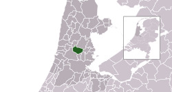 Location in North Holland | |||
| Koordinat: 52°30′N 4°49′E / 52.500°N 4.817°E | |||
| Country | Netherlands | ||
| Province | North Holland | ||
| Established | 1 January 1991 | ||
| Pamréntahan | |||
| • Lembaga | Municipal council | ||
| • Mayor | Judith Michel-de Jong (PvdA) | ||
| Jimbar | |||
| • Total | 45,18 km2 (1,744 sq mi) | ||
| • Darat | 38,59 km2 (1,490 sq mi) | ||
| • Air | 6,59 km2 (2,54 sq mi) | ||
| Ketinggian | −1 m (−3 ft) | ||
| Populasi (Januari 2021)[4] | |||
| • Total | 16.333 | ||
| • Kepadatan | 423/km2 (1,100/sq mi) | ||
| Wewidangan galah | UTC+1 (CET) | ||
| • Musim panas (DST) | UTC+2 (CEST) | ||
| Postcode | 1456–1458, 1530–1534, 1546 | ||
| Area code | 0299, 075 | ||
| Situs web | www | ||


Wormerland (pangucapang Welanda: [ˈʋɔrmərlɑnt] (![]() dingehang)) inggih punika kotamadya ring Belanda, ring propinsi Holland Kalér.
dingehang)) inggih punika kotamadya ring Belanda, ring propinsi Holland Kalér.
Galéri
-
 Town hall of Wormerland
 -
 Wormer
 -
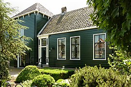 Wormer-Dorpstraat 298
 -
 Neck, village in Wormerland municipality


Pustaka
- ↑ "College van burgemeester en wethouders" [Board of Mayor and Aldermen] (ring Belanda). Gemeente Wormerland. Kaaksés 1 July 2024.
- ↑ "Kerncijfers wijken en buurten 2020" [Key figures for neighbourhoods 2020]. StatLine (ring Belanda). CBS. 24 Juli 2020. Kaaksés 19 Séptémber 2020.
- ↑ "Postcodetool for 1531NX". Actueel Hoogtebestand Nederland (ring Belanda). Het Waterschapshuis. Kaarsipin saking versi asli tanggal 21 September 2013. Kaaksés 24 March 2014. Check date values in:
|archive-date=(help) - ↑ "Bevolkingsontwikkeling; regio per maand" [Population growth; regions per month]. CBS Statline (ring Belanda). CBS. 1 Januari 2021. Kaaksés 2 Januari 2022.
Pranala jaba
 Média kakait indik Wormerland ring Wikimedia Commons
- Official website
 |
Alkmaar | Kaja | Purmerend |
|
| Kauh | Kangin | |||
| ||||
| Zaanstad | Oostzaan | Landsmeer |

Pengawasan otoritas | |
|---|---|
| Perpustakaan nasional | |
| Lain-lain |
|