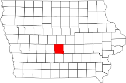
Polk County, Iowa
| Vawoitung | |
|---|---|
| US-Bundesstoot: | Iowa |
| Sitz vo da Vawoitung: | Des Moines |
| Adress vom Vawoitungssitz: |
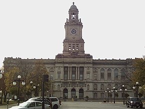
County Administrative Office Bldg. 111 Court Avenue Des Moines, IA 50309-2218 |
| Grindung: | 1846 |
| Buidt aus: | Original-County |
| Vuawoi: | 001 515 |
| Demographie | |
| Eihwohna: | 430.640 (2010) |
| Dichtn: | 292 Eihwohna/km² |
| Eadkund | |
| Flächn gesamt: | 1.533 km² |
| Wossaflächn: | 58 km² |
| Koartn | |
 | |
| Hoamseitn: www.polkcountyiowa.gov | |
Polk County[2] is a Beziak im Bundesstoot Iowa in da USA. Da Beziak hod 430.640 Eihwohna. Da Sitz vo da Vawoitung is Des Moines.
Da Beziak hod a Fläche vo 1533 Quadratkilometa, dovo san 58 Quadratkilometa Wossafläche.
Gmoana
- Alleman
- Altoona
- Ankeny
- Bondurant
- Carlisle
- Clive
- Des Moines
- Elkhart
- Granger
- Grimes
- Johnston
- Mitchellville
- Norwalk
- Pleasant Hill
- Polk City
- Runnells
- Sheldahl
- Urbandale
- West Des Moines
- Windsor Heights
- Saylorville
- Adelphi
- Adventureland Estates
- Avon
- Berwick
- Camp Dodge
- Capitol Heights
- Carbondale
- Carney
- Clover Hills
- Commerce
- Crocker
- East Des Moines
- East Fourteenth
- Farrar
- Enterprise
- Herrold
- Highland Park
- Ivy
- Lovington
- Lundstrom Heights
- Marquisville
- Norwoodville
- Oralabor
- Risingsun
- Santiago
- Saydel
- South Des Moines
- White Oak
Beleg
- ↑ Auszug aus dem National Register of Historic Places (Memento des Originals [1] vom 4. Mäerz 2016 im Internet Archive)
 Info: Der Archivlink wurde automatisch eingesetzt und noch nicht geprüft. Bitte prüfe Original- und Archivlink gemäß Anleitung und entferne dann diesen Hinweis.. Obgruafa am 13. Meaz 2011
- ↑ Polk County im Geographic Names Information System vom United States Geological Survey
|
Countys in Iowa
|
Koordinaten: 41° 41′ N, 93° 34′ W