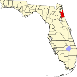
St. Johns County, Florida

| Vawoitung | |
|---|---|
| US-Bundesstoot: | Florida |
| Sitz vo da Vawoitung: | St. Augustine |
| Adress vom Vawoitungssitz: |
St. Johns County Local Government 4020 Lewis Speedway St. Augustine, Florida 32095 |
| Grindung: | 1821 |
| Buidt aus: | Original-County |
| Vuawoi: | 001 904 |
| Demographie | |
| Eihwohna: | 190.039 (2010) |
| Dichtn: | 120,5 Eihwohna/km² |
| Eadkund | |
| Flächn gesamt: | 2.127 km² |
| Wossaflächn: | 550 km² |
| Koartn | |
 | |
| Hoamseitn: www.co.st-johns.fl.us | |
St. Johns County[1] is a Beziak im Bundesstoot Florida in da USA. Da Beziak hod 190.039 Eihwohna. Da Sitz vo da Vawoitung is in St. Augustine.
Da Beziak hod a Fläch vo 2127 Quadratkilometa, dovo san 550 Quadratkilometa Wossaflächn.
Gmoana
- Anastasia
- Araquey
- Armstrong
- Bakersville
- Blacks Ford
- Butler Beach
- Byrd
- Casa Cola
- College Park
- Coquina Gables
- Crescent Beach
- Davis Shores
- Dupont Center
- Durbin
- Elkton
- Elwood
- Fort Matanzas
- Fruit Cove
- Gopher Ridge
- Hastings
- Hilden
- Marineland
- Meldrim Park
- Molasses Junction
- Moultrie
- Moultrie Junction
- Orangedale
- Palm Valley
- Palm Valley Landing
- Palmo
- Picolata
- Pine Bluff
- Ponte Vedra
- Ponte Vedra Beach
- Riverdale
- St. Augustine
- St. Augustine Beach
- St. Augustine Shores
- St. Augustine South
- Sampson
- Sawgrass
- South Ponte Vedra Beach
- Spuds
- Summer Haven
- Switzerland
- Tocoi
- Twentymile
- Usina Beach
- Vermont Heights
- Vilano Beach
- Villano Beach
- Whites Ford
- Yelvington
Beleg
- ↑ GNIS-ID: 308371. Abgerufen am 22. Februar 2011 (englisch).
Im Netz
 Commons: St. Johns County, Florida – Sammlung vo Buidl, Videos und Audiodateien
- St. Johns County Government (engl.)
|
Alachua | Baker | Bay | Bradford | Brevard | Broward | Calhoun | Charlotte | Citrus | Clay | Collier | Columbia | DeSoto | Dixie | Duval | Escambia | Flagler | Franklin | Gadsden | Gilchrist | Glades | Gulf | Hamilton | Hardee | Hendry | Hernando | Highlands | Hillsborough | Holmes | Indian River | Jackson | Jefferson | Lafayette | Lake | Lee | Leon | Levy | Liberty | Madison | Manatee | Marion | Martin | Miami-Dade | Monroe | Nassau | Okaloosa | Okeechobee | Orange | Osceola | Palm Beach | Pasco | Pinellas | Polk | Putnam | Santa Rosa | Sarasota | Seminole | St. Johns | St. Lucie | Sumter | Suwannee | Taylor | Union | Volusia | Wakulla | Walton | Washington |
Koordinaten: 29° 55′ N, 81° 25′ W