Портолан

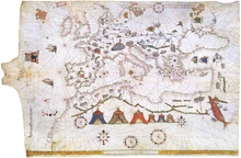

Портолан или Портулан (на латински: Portolan, Portulan; на италиански: portolano от лат.: portus – „пристанище“) е книга с информации за земи, фарове, реки и пристанища.
Използването на понятието е доказано за пръв път през 1285 г. От 16 век понятието се разширява и съдържа не само текста, а и морските карти. През 19 век учените започват да наричат всички морски карти като „Портулан“.
Литература
- Monique de La Roncière / Michel Mollat Du Jourdin [u.a.]: Les Portulans: cartes marines du XIIIe au XVIIe siècle, Paris [u.a.] 1984, ISBN 2-09-290538-4
- Konrad Kretschmer: Die italienischen Portolane des Mittelalters: ein Beitrag zur Geschichte der Kartographie und Nautik, Nachdruck der Ausgabe Berlin 1909, Hildesheim 1962.
- Peter Mesenburg: Portolankarten belegen hohe Kunst der Ingenieure im Mittelalter, in: Essener Universitätsberichte 2 (1988), S. 16 – 21.
- Helmut Minow: Rätsel der mittelalterlichen Seekarten. in: Deutsches Schiffahrtsarchiv (21 – 1998), S. 411 – 428.
Външни препратки
- www.spektrum.de
- Portolan Charts mini-site, University of Minnesota
- Portolan Charts, Samples of portolan charts illustrating the harbors and trade routes of the Mediterranean, 14th–16th centuries, from the Beinecke Rare Book and Manuscript Library, Yale University
- Portolan charts from S.XIII to S.XVI – Additions, Corrections, Updates
- J. Rey Pastor & E. Garcia Camarero La cartografía mallorquina
- Portolan Charts Архив на оригинала от 2011-07-08 в Wayback Machine. butronmaker
- BigThink: Portolan Charts 'Too Accurate' to be Medieval