Malimono
Malimono | |
|---|---|
Municipality | |
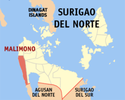 Mapa de Surigao del Norte con Malimono resaltado | |
| Coordinates: 9°37'6"N, 125°24'7"E | |
| Nación | Filipinas |
| Región | Caraga (Región XIII) |
| Provincia | Surigao del Norte |
| Número de barangay | 14 |
| Gobierno | |
| • Type | Sangguniang Bayan |
| • Electorado | 14 452 votantes (9 Mayo 2022) |
| Area | |
• Total | 80,13 kilómetro cuadrado km2 (Formatting error: invalid input when rounding sq mi) |
| Elevation | 178 metro m (Bad rounding hereFormatting error: invalid input when rounding ft) |
| Population (1 Mayo 2020) | |
• Total | 18 852 |
| • Hogares | 4629 |
| Economía | |
| • Clase de ingresos | es un aca cinco clase de municipalidad |
| • Incidencia de la pobreza | 31,82 |
| • Ingresos | ₱ 90,49 million (2020) |
| • Activos | ₱ 327,4 million (2020) |
| • Pasivos | ₱ 119 million (2020) |
| • Gastos | ₱ 73,99 million (2020) |
| Time zone | UTC+8 (PST) |
| Código postal | 8402 |
| PSGC | |
| Código telefonico | 86 |
| Clima | clima ecuatorial |
| Lenguaje nativo | idioma surigaense Agusan Cebuano Tagalog |
| Website | http://www.malimono.gov.ph/ |
Malimono es un aca cinco clase de municipalidad na provincia de Surigao del Norte, [[Filipinas]]. Tiene este zona de 80.13 kilómetro cuadrado kilometro cuadrado. Comporme del 1 Mayo 2020 censo este tiene papulidad de 18,852 personas y 4,629 hogares. El designada codigo postal 8402 y PSGC 166715000.
Barangay
- Bunyasan
- Cagtinae
- Can-aga
- Cansayong
- Cantapoy
- Cayawan
- Doro (Binocaran)
- Hanagdong
- Karihatag
- Masgad
- Pili
- San Isidro (Pob.)
- Tinago
- Villariza
Demografía
| Año | Populación | ±% p.a. |
|---|---|---|
| 1960 | 6537 | — |
| 1970 | 9412 | +3.71% |
| 1975 | 10 074 | +1.37% |
| 1980 | 12 109 | +3.75% |
| 1990 | 16 208 | +2.96% |
| 1995 | 14 191 | −2.46% |
| 2000 | 14 597 | +0.61% |
| 2007 | 16 883 | +2.03% |
| 2010 | 18 316 | +3.01% |
| 2015 | 18 054 | −0.27% |
| 2020 | 18 852 | +0.85% |
| Ref: Autoridad de Estadísticas de Filipinas[3][4][5][6] | ||
Referencias
- ↑
"Province: Surigao del Norte". PSGC Interactive. Quezon City, Philippines: Philippine Statistics Authority. Retrieved Diciembre 17, 2016.
{cite web}: Check date values in:|accessdate=(help) - ↑ "PSA Releases the 2021 City and Municipal Level Poverty Estimates". Autoridad de Estadística de Filipinas. 2 Abril 2024. Retrieved 28 Abril 2024.
- ↑
Census of Population (2015). "Caraga". Total Population by Province, City, Municipality and Barangay. Philippine Statistics Authority.
{cite encyclopedia}: External link in|chapterurl=|chapterurl=ignored (|chapter-url=suggested) (help)CS1 maint: numeric names: authors list (link) - ↑
Census of Population and Housing (2010). "Caraga". Total Population by Province, City, Municipality and Barangay. NSO.
{cite encyclopedia}: External link in|chapterurl=|chapterurl=ignored (|chapter-url=suggested) (help)CS1 maint: numeric names: authors list (link) - ↑
Censuses of Population (1903–2007). "Caraga". Table 1. Population Enumerated in Various Censuses by Province/Highly Urbanized City: 1903 to 2007. NSO.
{cite encyclopedia}: External link in|chapterurl=|chapterurl=ignored (|chapter-url=suggested) (help)CS1 maint: numeric names: authors list (link) CS1 maint: url-status (link) - ↑
"Province of Surigao del Norte". Municipality Population Data. Local Water Utilities Administration Research Division. Retrieved Diciembre 17, 2016.
{cite web}: Check date values in:|accessdate=(help)
Enlaces externos
- PhilAtlas.com
- Philippine Standard Geographic Code
- Local Governance Performance Management System
- www
.malimono .gov .ph
| Ciudad de Surigao (cabecera) | |
| Municipalidad: | Alegria ▪ Bacuag ▪ Burgos ▪ Claver ▪ Dapa ▪ Del Carmen ▪ General Luna ▪ Gigaquit ▪ Mainit ▪ Malimono ▪ Pilar ▪ Placer ▪ San Benito ▪ San Francisco ▪ San Isidro ▪ Santa Monica ▪ Sison ▪ Socorro ▪ Tagana-an ▪ Tubod |
| Ciudad: | Ciudad de Surigao |