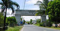
San Luis, Pampanga
San Luis | |
|---|---|
Municipality | |
 | |
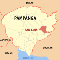 Mapa de Pampanga con San Luis resaltado | |
| Coordinates: 15°2'24"N, 120°47'31"E | |
| Nación | Filipinas |
| Región | Luzon Central (Región III) |
| Provincia | Pampanga |
| Número de barangay | 17 |
| Fundación | 1761 |
| Gobierno | |
| • Type | Sangguniang Bayan |
| • Electorado | 36 761 votantes (9 Mayo 2022) |
| Area | |
• Total | 56,83 kilómetro cuadrado km2 (Formatting error: invalid input when rounding sq mi) |
| Elevation | 8 metro m (Bad rounding hereFormatting error: invalid input when rounding ft) |
| Population (1 Mayo 2020) | |
• Total | 58 551 |
| • Hogares | 12 836 |
| Economía | |
| • Clase de ingresos | es un tercera clase de municipalidad |
| • Incidencia de la pobreza | 11,86 |
| • Ingresos | ₱ 229,5 million (2022) |
| • Activos | ₱ 632,2 million (2022) |
| • Pasivos | ₱ 159,7 million (2022) |
| • Gastos | ₱ 141,9 million (2022) |
| Time zone | UTC+8 (PST) |
| Código postal | 2014 |
| PSGC | |
| Código telefonico | 45 |
| Clima | clima monzónico |
| Lenguaje nativo | pampango Tagalog |
San Luis es un tercera clase de municipalidad na provincia de Pampanga, [[Filipinas]]. Tiene este zona de 56.83 kilómetro cuadrado kilometro cuadrado. Comporme del 1 Mayo 2020 censo este tiene papulidad de 58,551 personas y 12,836 hogares. El designada codigo postal 2014 y PSGC 035417000.
Barangay
|
|
Demografía
| Año | Populación | ±% p.a. |
|---|---|---|
| 1903 | 10 067 | — |
| 1918 | 9830 | −0.16% |
| 1939 | 10 966 | +0.52% |
| 1948 | 9472 | −1.61% |
| 1960 | 14 873 | +3.83% |
| 1970 | 20 205 | +3.11% |
| 1975 | 23 866 | +3.40% |
| 1980 | 25 701 | +1.49% |
| 1990 | 31 920 | +2.19% |
| 1995 | 36 005 | +2.28% |
| 2000 | 41 554 | +3.12% |
| 2007 | 47 517 | +1.87% |
| 2010 | 49 311 | +1.36% |
| 2015 | 54 106 | +1.78% |
| 2020 | 58 551 | +1.56% |
| Ref: Autoridad de Estadísticas de Filipinas[3][4][5][6] | ||
Referencias
- ↑
"Province: Pampanga". PSGC Interactive. Quezon City, Philippines: Philippine Statistics Authority. Retrieved Diciembre 17, 2016.
{cite web}: Check date values in:|accessdate=(help) - ↑ "PSA Releases the 2021 City and Municipal Level Poverty Estimates". Autoridad de Estadística de Filipinas. 2 Abril 2024. Retrieved 28 Abril 2024.
- ↑
Census of Population (2015). "Region III (Central Luzon)". Total Population by Province, City, Municipality and Barangay. Philippine Statistics Authority.
{cite encyclopedia}: External link in|chapterurl=|chapterurl=ignored (|chapter-url=suggested) (help)CS1 maint: numeric names: authors list (link) - ↑
Census of Population and Housing (2010). "Region III (Central Luzon)". Total Population by Province, City, Municipality and Barangay. NSO.
{cite encyclopedia}: External link in|chapterurl=|chapterurl=ignored (|chapter-url=suggested) (help)CS1 maint: numeric names: authors list (link) - ↑
Censuses of Population (1903–2007). "Region III (Central Luzon)". Table 1. Population Enumerated in Various Censuses by Province/Highly Urbanized City: 1903 to 2007. NSO.
{cite encyclopedia}: External link in|chapterurl=|chapterurl=ignored (|chapter-url=suggested) (help)CS1 maint: numeric names: authors list (link) CS1 maint: url-status (link) - ↑
"Province of Pampanga". Municipality Population Data. Local Water Utilities Administration Research Division. Retrieved Diciembre 17, 2016.
{cite web}: Check date values in:|accessdate=(help)
Enlaces externos
| San Fernando (cabecera) | |
| Municipalidad: | Apalit ▪ Arayat ▪ Bácolor ▪ Candaba ▪ Floridablanca ▪ Guagua ▪ Lubao ▪ Macabebe ▪ Magalang ▪ Masantol ▪ Mexico ▪ Minalin ▪ Pórac ▪ San Luis ▪ San Simon ▪ Santa Ana ▪ Santa Rita ▪ Santo Tomas ▪ Sasmuan |
| Ciudad: | Ángeles ▪ Mabalacat ▪ San Fernando |