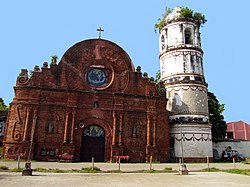
Tumauini
Tumauini | |
|---|---|
Municipality | |
 | |
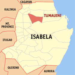 Mapa de Isabela con Tumauini resaltado | |
| Coordinates: 17°16'N, 121°48'E | |
| Nación | Filipinas |
| Región | Valle de Cagayán (Región II) |
| Provincia | Isabela |
| Número de barangay | 46 |
| Fundación | 1751 |
| Gobierno | |
| • Type | Sangguniang Bayan |
| • Electorado | 47 850 votantes (9 Mayo 2022) |
| Area | |
• Total | 467,30 kilómetro cuadrado km2 (Formatting error: invalid input when rounding sq mi) |
| Elevation | 42 metro m (Bad rounding hereFormatting error: invalid input when rounding ft) |
| Population (1 Mayo 2020) | |
• Total | 70 743 |
| • Hogares | 16 825 |
| Economía | |
| • Clase de ingresos | es un primera clase de municipalidad |
| • Incidencia de la pobreza | 16,80 |
| • Ingresos | ₱ 299,5 million (2020) |
| • Activos | ₱ 720,5 million (2020) |
| • Pasivos | ₱ 274,5 million (2020) |
| • Gastos | ₱ 293,7 million (2020) |
| Time zone | UTC+8 (PST) |
| Código postal | 3325 |
| PSGC | |
| Código telefonico | 78 |
| Clima | clima ecuatorial |
| Lenguaje nativo | Ibanag ilocano Tagalog |
| Website | http://www.tumauini-isabela.gov.ph/ |
Tumauini es un primera clase de municipalidad na provincia de Isabela, [[Filipinas]]. Tiene este zona de 467.30 kilómetro cuadrado kilometro cuadrado. Comporme del 1 Mayo 2020 censo este tiene papulidad de 70,743 personas y 16,825 hogares. El designada codigo postal 3325 y PSGC 023137000.
Barangay
|
|
|
Demografía
| Año | Populación | ±% p.a. |
|---|---|---|
| 1903 | 4890 | — |
| 1918 | 7147 | +2.56% |
| 1939 | 14 343 | +3.37% |
| 1948 | 19 190 | +3.29% |
| 1960 | 16 606 | −1.20% |
| 1970 | 23 427 | +3.50% |
| 1975 | 27 669 | +3.39% |
| 1980 | 31 967 | +2.93% |
| 1990 | 40 664 | +2.44% |
| 1995 | 45 551 | +2.15% |
| 2000 | 50 256 | +2.13% |
| 2007 | 55 041 | +1.26% |
| 2010 | 58 463 | +2.22% |
| 2015 | 67 650 | +2.82% |
| 2020 | 70 743 | +0.88% |
| Ref: Autoridad de Estadísticas de Filipinas[3][4][5][6] | ||
Referencias
- ↑
"Province: Isabela". PSGC Interactive. Quezon City, Philippines: Philippine Statistics Authority. Retrieved Diciembre 17, 2016.
{cite web}: Check date values in:|accessdate=(help) - ↑ "PSA Releases the 2021 City and Municipal Level Poverty Estimates". Autoridad de Estadística de Filipinas. 2 Abril 2024. Retrieved 28 Abril 2024.
- ↑
Census of Population (2015). "Region II (Cagayan Valley)". Total Population by Province, City, Municipality and Barangay. Philippine Statistics Authority.
{cite encyclopedia}: External link in|chapterurl=|chapterurl=ignored (|chapter-url=suggested) (help)CS1 maint: numeric names: authors list (link) - ↑
Census of Population and Housing (2010). "Region II (Cagayan Valley)". Total Population by Province, City, Municipality and Barangay. NSO.
{cite encyclopedia}: External link in|chapterurl=|chapterurl=ignored (|chapter-url=suggested) (help)CS1 maint: numeric names: authors list (link) - ↑
Censuses of Population (1903–2007). "Region II (Cagayan Valley)". Table 1. Population Enumerated in Various Censuses by Province/Highly Urbanized City: 1903 to 2007. NSO.
{cite encyclopedia}: External link in|chapterurl=|chapterurl=ignored (|chapter-url=suggested) (help)CS1 maint: numeric names: authors list (link) CS1 maint: url-status (link) - ↑
"Province of Isabela". Municipality Population Data. Local Water Utilities Administration Research Division. Retrieved Diciembre 17, 2016.
{cite web}: Check date values in:|accessdate=(help)
Enlaces externos
- PhilAtlas.com
- Philippine Standard Geographic Code
- Local Governance Performance Management System
- www
.tumauini-isabela .gov .ph
| Ilagan (cabecera) | |
| Municipalidad: | Alicia ▪ Angadanan ▪ Aurora ▪ Benito Soliven ▪ Burgos ▪ Cabagan ▪ Cabatuan ▪ Cordon ▪ Delfin Albano ▪ Dinapigue ▪ Divilacan ▪ Echagüe ▪ Gamu ▪ Jones ▪ Luna ▪ Maconacon ▪ Mallig ▪ Naguilian ▪ Palanan ▪ Quezon ▪ Quirino ▪ Ramon ▪ Reina Mercedes ▪ Roxas ▪ San Agustin ▪ San Guillermo ▪ San Isidro ▪ San Manuel ▪ San Mariano ▪ San Mateo ▪ San Pablo ▪ Santa Maria ▪ Santo Tomas ▪ Tumauini |
| Ciudad: | Cauayan ▪ Ilagan ▪ Santiago |