Albera Massif
| Albera Massif | |
|---|---|
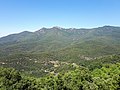
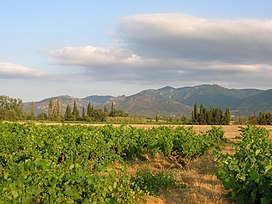 The northern side of the Albera Massif seen from Sant Genís de Fontanes | |
| Highest point | |
| Elevation | 1,256 m (4,121 ft) |
| Coordinates | 42°28′55″N 2°56′49″E / 42.48194°N 2.94694°E |
| Geography | |
 Albera Massif Location in the Pre-Pyrenees area | |
| Location | Pyrénées-Orientales Empordà, Catalonia |
| Parent range | Foothills of the Pyrenees |
| Climbing | |
| First ascent | Unknown |
| Easiest route | From La Jonquera or Sureda |
The Albera Massif (Catalan: Serra de l'Albera; French: Massif des Albères) is a mountain range located in the south of Pyrénées-Orientales and the north of Catalonia, between France and Spain. It is the main easternmost prolongation of the Pyrenees. Its highest peak is the Puig Neulós, with an elevation of 1,256 metres.[1]
Most of the southern side of the range is part of the Paratge Natural d'Interès Nacional de l'Albera natural reserve.[2] There are some ancient megaliths in the range.[3] The Col du Perthus marks the western boundary of the massif.
The massif is at the eastern end of the "Axial Zone" of the Pyrenees mountain range. As in most of that zone, the geological formations in the massif are mostly of Paleozoic and earlier ages, with granite, gneiss, and schists (and other metasediments) being the predominant formations.[4][5]
On the northern slopes of the massif, the Albères fault (which runs roughly west to east from near Le Boulou to near Argelès) marks a clear geological and topographical boundary between the Palaeozoic and older formations of the Albera massif and the Neogene deposits of the Roussillon basin.[6]


History
The Albera Range became the border between France and Spain following the Treaty of the Pyrenees, when Philip IV of Spain ceded a part of the Spanish kingdom to Louis XIV of France, dividing Northern Catalonia from Historical Catalonia.
Gallery
-
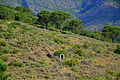 Albera Massif
 -
 Albera Massif
 -
 Albera Massif
 -
 Albera Massif
 -
 Puig Neulós
 -
 Puig Sallfort seen from the Tour de Querroig.
 -
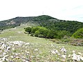
 Puig de Sant Cristau, towards the western end of the massif.
 -
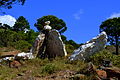
 Granite outcrop, above La Jonquera.


See also
References
- ^ Topographical map extract (in Géoportail).
- ^ Paratge Natural d'Interès Nacional de l'Albera. Col·lecció 1:25.000. Espais naturals protegits, Barcelona, Institut Cartogràfic de Catalunya, 1999
- ^ Monuments megalítics de l'Albera
- ^ Geological map extract (in Géoportail).
- ^ a b Notice explicative de la feuille Argelès-sur-Mer - Cerbère (1097) à 1/50 000, BRGM Éditions, Orléans, 2015.
- ^ Marc Calvet, Magali Delmas, Yanni Gunnell, Bernard Laumonier, Geology and Landscapes of the Eastern Pyrenees, Springer International Publishing, Kindle edition, 2022, pages 314-333.
External links
- Paratge Natural d'Interès Nacional de l'Albera
- Requesens - Puig Neulós hiking route
- Manel Figuera i Abadal, 50 ascensions fàcils pel Pirineu català, Valls, Cossetània, 2008
- Centre de reproducció de tortugues de l'Albera
| International | |
|---|---|
| National | |