Ama District

Ama (海部郡, Ama-gun) is a district located in Aichi Prefecture, Japan.
As of October 1, 2019, the district has an estimated population of 74,009 with a density of 1,846 persons per km2. The total area is 40.09 km2.
Municipalities
The district consists of two towns and one village:
History
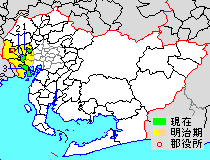
* yellow - areas formerly within the district borders during the early Meiji period
- Ōharu-machi
- Kanie-machi
- Tobishima-mura

District Timeline
Recent mergers
- On April 1, 2005 - The towns of Saya and Saori, and the villages of Hachikai and Tatsuta were merged into the expanded city of Aisai.
- On April 1, 2006 - The former town of Yatomi absorbed the village of Jūshiyama to form the city of Yatomi.
- On March 22, 2010 - The towns of Shippō, Jimokuji and Miwa were merged to form the city of Ama.[1]
Notes
References
- ^ 矢野恒太記念会 (2021-12-01). データでみる県勢2022: 日本国勢図会地域統計版 (in Japanese). 矢野恒太記念会. p. 504. ISBN 978-4-87549-347-1.
| Nagoya |
| |||
|---|---|---|---|---|
| Core cities | ||||
| Special city | ||||
| Cities | ||||
| Districts | ||||
| Former Districts | ||||
| International | |
|---|---|
| National | |