Bélesta, Pyrénées-Orientales
Bélesta
Belhestar | |
|---|---|
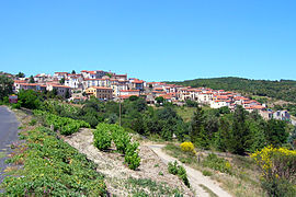 A general view of Bélesta | |
 Coat of arms | |
 Bélesta  Bélesta | |
| Coordinates: 42°43′06″N 2°36′28″E / 42.7183°N 2.6078°E | |
| Country | France |
| Region | Occitania |
| Department | Pyrénées-Orientales |
| Arrondissement | Prades |
| Canton | La Vallée de l'Agly |
| Intercommunality | Roussillon-Conflent |
| Government | |
| • Mayor (2020–2026) | Frédéric Bourniole[1] |
| Area 1 | 20.52 km2 (7.92 sq mi) |
| Population (2021)[2] | 212 |
| • Density | 10/km2 (27/sq mi) |
| Time zone | UTC+01:00 (CET) |
| • Summer (DST) | UTC+02:00 (CEST) |
| INSEE/Postal code | 66019 /66720 |
| Elevation | 122–561 m (400–1,841 ft) (avg. 380 m or 1,250 ft) |
| 1 French Land Register data, which excludes lakes, ponds, glaciers > 1 km2 (0.386 sq mi or 247 acres) and river estuaries. | |
Bélesta (French pronunciation: [belɛsta] ⓘ; Occitan: Bèl Estar; Catalan: Bellestar) is a commune in the Pyrénées-Orientales department in southern France.
Geography
Localisation
Bélesta is located in the canton of La Vallée de l'Agly and in the arrondissement of Perpignan.

Government and politics
- Mayors
| Mayor | Term start | Term end |
|---|---|---|
| Jacques Biles[3] | ? | June 1815 |
| Baptiste Pugnaud[3] | June 1815 | ? |
| Gilbert Bourniole | 2001 | 2007 |
| Roger Morin | 2007 | 2014 |
| Frédéric Bourniole | 2014 |
Population
| Year | Pop. | ±% p.a. |
|---|---|---|
| 1968 | 312 | — |
| 1975 | 262 | −2.46% |
| 1982 | 247 | −0.84% |
| 1990 | 223 | −1.27% |
| 1999 | 215 | −0.41% |
| 2007 | 214 | −0.06% |
| 2012 | 225 | +1.01% |
| 2017 | 221 | −0.36% |
| Source: INSEE[4] | ||
Sites of interest
- Prehistory museum
- Bélesta dolmen
- Bélesta cave
- Church of Saint Barthelemy in Bélesta
- Church of Saint Barthelemy in Jonqueroles
- Llébrès, an abandoned medieval hamlet
- Caladroy, hamlet with Château de Caladroy and an important winery
-
 Bélesta dolmen
 -
 Medieval gate
 -
 Ancien fortification
 -
 Church of Saint Barthelemy de Bélesta church (west)
 -
 Church of Saint Barthelemy de Bélesta church (northeast)
 -
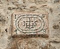 Inscription above the portal of Saint-Barthélemy de Bélesta church, dated 1648
 -
 Museum of prehistory
 -
 Château de Caladroy
 -
 Chapel Sacré-Cœur de Jésus of château de Caladroy
 -
 Chapel Saint-Michel of château de Caladroy


See also
References
- ^ "Répertoire national des élus: les maires". data.gouv.fr, Plateforme ouverte des données publiques françaises (in French). 2 December 2020.
- ^ "Populations légales 2021". The National Institute of Statistics and Economic Studies. 28 December 2023.
- ^ a b Fabricio Cardenas, Vieux papiers des Pyrénées-Orientales, Bélesta, le 21 juin 1815, 31 january 2014
- ^ Population en historique depuis 1968, INSEE
Wikimedia Commons has media related to Bélesta (Pyrénées-Orientales).