Bořanovice
Bořanovice | |
|---|---|
 Pivovarská street | |
 Flag  Coat of arms | |
 Bořanovice Location in the Czech Republic | |
| Coordinates: 50°10′42″N 14°28′44″E / 50.17833°N 14.47889°E | |
| Country | |
| Region | Central Bohemian |
| District | Prague-East |
| First mentioned | 1227 |
| Area | |
| • Total | 5.35 km2 (2.07 sq mi) |
| Elevation | 249 m (817 ft) |
| Population (2023-01-01)[1] | |
| • Total | 948 |
| • Density | 180/km2 (460/sq mi) |
| Time zone | UTC+1 (CET) |
| • Summer (DST) | UTC+2 (CEST) |
| Postal code | 250 65 |
| Website | www |
Bořanovice is a municipality and village in Prague-East District in the Central Bohemian Region of the Czech Republic. It has about 900 inhabitants.
Administrative parts
The village of Pakoměřice is an administrative part of Bořanovice.
Geography
Bořanovice is located about 6 kilometres (4 mi) north of Prague. It lies mostly in an agricultural landscape of the Central Elbe Table, but the western part of the municipal territory extends into the Prague Plateau.
History
The first written mention of Bořanovice is from 1227. Pakoměřice was first documented in 1352, when the church was mentioned.[2]
Sights
In Pakoměřice there is the complex of a rural castle with the Church of the Nativity of the Virgin Mary. The church was originally a Gothic building, later baroque rebuilt. The castle was originally a medieval fortress which underwent Renaissance, Baroque and Neoclassical modifications.[3]
Gallery
-
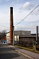 Former brewery
 -
 K Ubytovně street


References
- ^ "Population of Municipalities – 1 January 2023". Czech Statistical Office. 2023-05-23.
- ^ "Historie obce" (in Czech). Obec Bořanovice. Retrieved 2022-05-04.
- ^ "Zámek s kostelem" (in Czech). National Heritage Institute. Retrieved 2022-05-04.
External links
| Authority control databases: National |
|---|