Combiers
Combiers | |
|---|---|
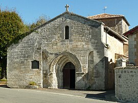 The church in Combiers | |
 Coat of arms | |
 Combiers  Combiers | |
| Coordinates: 45°29′36″N 0°24′56″E / 45.4933°N 0.4156°E | |
| Country | France |
| Region | Nouvelle-Aquitaine |
| Department | Charente |
| Arrondissement | Angoulême |
| Canton | Tude-et-Lavalette |
| Intercommunality | Lavalette Tude Dronne |
| Government | |
| • Mayor (2020–2026) | Patrick Épaud[1] |
| Area 1 | 23.96 km2 (9.25 sq mi) |
| Population (Jan. 2021)[2] | 124 |
| • Density | 5.2/km2 (13/sq mi) |
| Time zone | UTC+01:00 (CET) |
| • Summer (DST) | UTC+02:00 (CEST) |
| INSEE/Postal code | 16103 /16320 |
| Elevation | 90–215 m (295–705 ft) (avg. 100 m or 330 ft) |
| 1 French Land Register data, which excludes lakes, ponds, glaciers > 1 km2 (0.386 sq mi or 247 acres) and river estuaries. | |
Combiers (French pronunciation: [kɔ̃bje]; Occitan: Combier) is a commune in the Charente department in southwestern France.
Geography
The Lizonne (locally called Nizonne) forms most of the commune's southern border.
Population
| Year | Pop. | ±% p.a. |
|---|---|---|
| 1968 | 214 | — |
| 1975 | 154 | −4.59% |
| 1982 | 145 | −0.86% |
| 1990 | 127 | −1.64% |
| 1999 | 115 | −1.10% |
| 2009 | 118 | +0.26% |
| 2014 | 125 | +1.16% |
| 2020 | 122 | −0.40% |
| Source: INSEE[3] | ||
Sights
- Arboretum Jean Aubouin
- The grandmontine priory of Rauzet
See also
References
- ^ "Répertoire national des élus: les maires" (in French). data.gouv.fr, Plateforme ouverte des données publiques françaises. 13 September 2022.
- ^ "Populations légales 2021". The National Institute of Statistics and Economic Studies. 28 December 2023.
- ^ Population en historique depuis 1968, INSEE
Wikimedia Commons has media related to Combiers.
| International | |
|---|---|
| National | |