Dropt
| Dropt | |
|---|---|
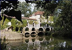 Moulin de Loubens sur le Dropt | |
  | |
| Physical characteristics | |
| Source | |
| • location | Massif Central |
| • coordinates | 44°41′9″N 0°57′24″E / 44.68583°N 0.95667°E |
| • elevation | 239 m (784 ft) |
| Mouth | |
• location | Garonne |
• coordinates | 44°34′58″N 0°6′35″W / 44.58278°N 0.10972°W |
| Length | 132 km (82 mi) |
| Basin size | 1,500 km2 (580 sq mi) |
| Discharge | |
| • average | 4.5 m3/s (160 cu ft/s) |
| Basin features | |
| Progression | Garonne→ Gironde estuary→ Atlantic Ocean |
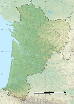
The Drot or Dropt (French pronunciation: [dʁo]) is a river in Nouvelle-Aquitaine, France. It is a right tributary to the Garonne. It is 132 km (82 mi) long.[1]
Geography
The source of the Dropt is located near Capdrot in the Dordogne. The drainage basin covers the area between the river valleys of the Lot and the Dordogne.
References
External links