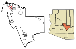
East Verde Estates, Arizona
East Verde Estates, Arizona | |
|---|---|
 Location of East Verde Estates in Gila County, Arizona. | |
| Coordinates: 34°17′54″N 111°21′52″W / 34.29833°N 111.36444°W | |
| Country | United States |
| State | Arizona |
| County | Gila |
| Area | |
• Total | 2.50 sq mi (6.48 km2) |
| • Land | 2.50 sq mi (6.48 km2) |
| • Water | 0.00 sq mi (0.00 km2) |
| Elevation | 4,613 ft (1,406 m) |
| Population (2020) | |
• Total | 151 |
| • Density | 60.30/sq mi (23.29/km2) |
| Time zone | UTC-7 (Mountain (MST)) |
| ZIP code | 85541[2] |
| Area code | 928 |
| GNIS feature ID | 2582778 |
East Verde Estates is a census-designated place in Gila County in the U.S. state of Arizona. East Verde Estates is located approximately six miles north of the town of Payson, off Arizona State Route 87. The population as of the 2010 U.S. Census was 170.[3]
Geography
East Verde Estates is located at 34°17′54″N 111°21′52″W / 34.298272°N 111.364552°W.
According to the U.S. Census Bureau, the community has an area of 2.504 square miles (6.49 km2), all land.[4]
Demographics
| Census | Pop. | Note | %± |
|---|---|---|---|
| 2020 | 151 | — | |
| U.S. Decennial Census[5] | |||
Education
It is in the Payson Unified School District.[6] Payson High School is the zoned comprehensive high school.
References
- ^ "2020 U.S. Gazetteer Files". United States Census Bureau. Retrieved October 29, 2021.
- ^ "East Verde Estates AZ ZIP Code". zipdatamaps.com. 2023. Retrieved May 3, 2023.
- ^ "2010 Census Interactive Population Search". census.gov. Archived from the original on April 17, 2014. Retrieved April 17, 2014.
- ^ "2010 Census Gazetteer Files: Places - Arizona". U.S. Census Bureau. Archived from the original on September 6, 2013. Retrieved July 16, 2014.
- ^ "Census of Population and Housing". Census.gov. Retrieved June 4, 2016.
- ^ "2020 CENSUS - SCHOOL DISTRICT REFERENCE MAP: Gila County, AZ" (PDF). U.S. Census Bureau. Retrieved September 12, 2024. - Text list


