Gadžin Han
Gadžin Han
Гаџин Хан (Serbian) | |
|---|---|
Village and municipality | |
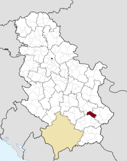
 Location of the municipality of Gadžin Han within Serbia | |
| Coordinates: 43°13′22″N 22°01′56″E / 43.22278°N 22.03222°E | |
| Country | |
| Region | Southern and Eastern Serbia |
| District | Nišava |
| Settlements | 34 |
| Government | |
| • Mayor | Milisav Filipović (SNS) |
| Area | |
| • Village | 7.76 km2 (3.00 sq mi) |
| • Municipality | 325 km2 (125 sq mi) |
| Elevation | 266 m (873 ft) |
| Population (2011 census)[2] | |
| • Municipality | 8,389 |
| • Municipality density | 26/km2 (67/sq mi) |
| Time zone | UTC+1 (CET) |
| • Summer (DST) | UTC+2 (CEST) |
| Postal code | 18240 |
| Area code | +381(0)18 |
| Car plates | NI |
| Website | gadzinhan |
Gadžin Han (Serbian Cyrillic: Гаџин Хан) is a village and municipality located in the Nišava District of the southern Serbia. According to 2011 census, the municipality has 8,389 inhabitants, from which 1,223 live in Gadžin Han itself.
Geography
The municipality borders Bela Palanka municipality and City of Niš in the north, Babušnica municipality in the south-east, Vlasotince and Leskovac municipalities in the south, and Doljevac municipality in the west.
Settlements
Aside from the town of Gadžin Han, the municipality includes the following settlements:
- Čagrovac
- Ćelije
- Donje Dragovlje
- Donji Barbeš
- Donji Dušnik
- Duga Poljana
- Dukat
- Gare
- Gornje Dragovlje
- Gornje Vlase
- Gornji Barbeš
- Gornji Dušnik
- Grkinja
- Jagličje
- Kaletinac
- Koprivnica (Gadžin Han)
- Krastavče
- Ličje
- Mali Krčimir
- Mali Vrtop
- Marina Kutina
- Miljkovac
- Novo Selo
- Ovsinjinac
- Ravna Dubrava
- Semče
- Sopotnica
- Šebet
- Taskovići
- Toponica
- Veliki Krčimir
- Veliki Vrtop
- Vilandrica
Demographics
| Year | Pop. | ±% p.a. |
|---|---|---|
| 1948 | 26,380 | — |
| 1953 | 26,182 | −0.15% |
| 1961 | 23,965 | −1.10% |
| 1971 | 19,974 | −1.81% |
| 1981 | 16,281 | −2.02% |
| 1991 | 12,990 | −2.23% |
| 2002 | 10,464 | −1.95% |
| 2011 | 8,389 | −2.43% |
| Source: [3] | ||
According to the last official census done in 2011, the municipality of Gadžin Han has 8,389 inhabitants.
Ethnic groups
The ethnic composition of the municipality:[4]
| Ethnic group | Population | % |
|---|---|---|
| Serbs | 7,972 | 95.03% |
| Roma | 260 | 3.10% |
| Croats | 4 | 0.05% |
| Macedonians | 3 | 0.04% |
| Montenegrins | 3 | 0.04% |
| Bulgarians | 3 | 0.04% |
| Russians | 3 | 0.04% |
| Others | 141 | 1.68% |
| Total | 5,934 |
Economy
The following table gives a preview of total number of employed people per their core activity (as of 2017):[5]
| Activity | Total |
|---|---|
| Agriculture, forestry and fishing | 1 |
| Mining | 12 |
| Processing industry | 590 |
| Distribution of power, gas and water | 9 |
| Distribution of water and water waste management | 3 |
| Construction | 110 |
| Wholesale and retail, repair | 159 |
| Traffic, storage and communication | 23 |
| Hotels and restaurants | 14 |
| Media and telecommunications | 21 |
| Finance and insurance | 1 |
| Property stock and charter | - |
| Professional, scientific, innovative and technical activities | 51 |
| Administrative and other services | 2 |
| Administration and social assurance | 104 |
| Education | 110 |
| Healthcare and social work | 84 |
| Art, leisure and recreation | 16 |
| Other services | 78 |
| Total | 1,388 |
See also
References
- ^ "Municipalities of Serbia, 2006". Statistical Office of Serbia. Retrieved 2010-11-28.
- ^ "2011 Census of Population, Households and Dwellings in the Republic of Serbia: Comparative Overview of the Number of Population in 1948, 1953, 1961, 1971, 1981, 1991, 2002 and 2011, Data by settlements" (PDF). Statistical Office of Republic Of Serbia, Belgrade. 2014. ISBN 978-86-6161-109-4. Retrieved 2014-06-27.
- ^ "2011 Census of Population, Households and Dwellings in the Republic of Serbia" (PDF). stat.gov.rs. Statistical Office of the Republic of Serbia. Retrieved 16 February 2018.
- ^ "ETHNICITY Data by municipalities and cities" (PDF). stat.gov.rs. Statistical Office of Serbia. Retrieved 16 February 2018.
- ^ "ОПШТИНЕ И РЕГИОНИ У РЕПУБЛИЦИ СРБИЈИ, 2018" (PDF). stat.gov.rs (in Serbian). Statistical Office of the Republic of Serbia. Retrieved 16 March 2019.

