Hořepník
Hořepník | |
|---|---|
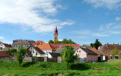 View from the southeast | |
 Flag  Coat of arms | |
 Hořepník Location in the Czech Republic | |
| Coordinates: 49°30′46″N 15°6′22″E / 49.51278°N 15.10611°E | |
| Country | |
| Region | Vysočina |
| District | Pelhřimov |
| First mentioned | 1252 |
| Area | |
| • Total | 13.63 km2 (5.26 sq mi) |
| Elevation | 457 m (1,499 ft) |
| Population (2023-01-01)[1] | |
| • Total | 642 |
| • Density | 47/km2 (120/sq mi) |
| Time zone | UTC+1 (CET) |
| • Summer (DST) | UTC+2 (CEST) |
| Postal codes | 394 21, 395 01 |
| Website | www |
Hořepník is a municipality and village in Pelhřimov District in the Vysočina Region of the Czech Republic. It has about 600 inhabitants.
Hořepník lies approximately 13 kilometres (8 mi) northwest of Pelhřimov, 38 km (24 mi) west of Jihlava, and 80 km (50 mi) south-east of Prague.
Administrative parts
Villages of Březina, Mašovice and Vítovice are administrative parts of Hořepník.
References
Wikimedia Commons has media related to Hořepník.
| Authority control databases: National |
|---|