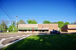
Hornbeak, Tennessee
Hornbeak, Tennessee
Wilsonville, Tennessee | |
|---|---|
 | |
 Location of Hornbeak in Obion County, Tennessee. | |
| Coordinates: 36°20′2″N 89°17′57″W / 36.33389°N 89.29917°W | |
| Country | United States |
| State | Tennessee |
| County | Obion |
| Settled | 1850's |
| Incorporated | 1916 |
| Named for | Frank Hornbeak |
| Government | |
| • Mayor | Betty Mae Walley |
| • Mayor | Betty Walley |
| Area | |
| • Total | 1.05 sq mi (2.72 km2) |
| • Land | 1.05 sq mi (2.72 km2) |
| • Water | 0.00 sq mi (0.00 km2) |
| Elevation | 476 ft (145 m) |
| Population | |
| • Total | 511 |
| • Density | 486.20/sq mi (187.74/km2) |
| Time zone | UTC-6 (Central (CST)) |
| • Summer (DST) | UTC-5 (CDT) |
| ZIP code | 38232 |
| Area code | 731 |
| FIPS code | 47-36000[4] |
| GNIS feature ID | 1288362[2] |
Hornbeak is a town in Obion County, Tennessee, United States. The population was 424 as of the 2010 census. It is part of the Union City, TN–KY Micropolitan Statistical Area.
History
Prior to the establishment of the town, in 1854 a school was started in what locals refer to as "old Center Cemetery," which is located just south of modern day Hornbeak. The school stayed in operation until 1885.[5]
Hornbeak was originally settled in the 1870's as Wilsonville. By 1887, the name was changed to Hornbeak, after Frank Hornbeak, a local store owner who also served as the postmaster. The town saw it's first bank, the Bank of Hornbeak, in 1904, incorporated in 1916 with John Hodge serving as the first mayor.[6]
Racial History
The Riders |1906
During the attempts to privately control Reelfoot Lake in 1906, “The Night Riders,” a domestic terrorist organization similar to the Klu Klux Klan in operation and motive,[7] came to the nearby town of Hornbeak and gave all the black families notice to get out. The Riders stated that when they returned any black still there would be killed. True to their word, The Riders returned the next day and rounded up all the black males they could find in short notice. They were mostly shot, a few hanged but all buried on private land, alongside State road 21, just inside the East current city limits on the North side. The women and children were spared, and all quickly relocated. For many years following the killings, the victims families visited on the weekend. As late as 1930 my mom witnessed them. They picnicked and kept the graves clean but after several years the owner fenced the land and bulldozed any markers that remained. My mother took me to the location in 1960 and pointed it out so that it would not be forgotten. (36.3400347, -89.2753623) My grandmother acknowledged having seen the acts, saying “I’ve seen The Riders and I’ve seen what they do!”, but refusing to speak further, visibly still shaken, after over 60 years.
Geography
Hornbeak is located at 36°20′2″N 89°17′57″W / 36.33389°N 89.29917°W (36.333879, -89.299292).[8]
According to the United States Census Bureau, the town has a total area of 0.6-square-mile (1.6 km2), all land.
Demographics
| Census | Pop. | Note | %± |
|---|---|---|---|
| 1930 | 422 | — | |
| 1940 | 382 | −9.5% | |
| 1950 | 309 | −19.1% | |
| 1960 | 307 | −0.6% | |
| 1970 | 418 | 36.2% | |
| 1980 | 452 | 8.1% | |
| 1990 | 445 | −1.5% | |
| 2000 | 435 | −2.2% | |
| 2010 | 424 | −2.5% | |
| 2020 | 511 | 20.5% | |
| Sources:[9][10][3] | |||
As of the census[4] of 2000, there were 435 people, 185 households, and 130 families residing in the town. The population density was 697.0 inhabitants per square mile (269.1/km2). There were 205 housing units at an average density of 328.5 per square mile (126.8/km2). The racial makeup of the town was 99.31% White, 0.23% African American, and 0.46% from two or more races.
There were 185 households, out of which 30.8% had children under the age of 18 living with them, 59.5% were married couples living together, 7.0% had a female householder with no husband present, and 29.2% were non-families. 25.9% of all households were made up of individuals, and 13.5% had someone living alone who was 65 years of age or older. The average household size was 2.35 and the average family size was 2.81.
In the town, the population was spread out, with 22.8% under the age of 18, 7.1% from 18 to 24, 29.0% from 25 to 44, 23.7% from 45 to 64, and 17.5% who were 65 years of age or older. The median age was 40 years. For every 100 females, there were 87.5 males. For every 100 females age 18 and over, there were 89.8 males.
The median income for a household in the town was $27,153, and the median income for a family was $31,389. Males had a median income of $29,167 versus $20,313 for females. The per capita income for the town was $11,657. About 13.5% of families and 14.7% of the population were below the poverty line, including 3.9% of those under age 18 and 26.5% of those age 65 or over.
Media
Radio Stations
- WENK-AM 1240 - "The Greatest Hits of All Time"
- WWGY 99.3 - "Today's Best Music with Ace & TJ in the Morning"
References
- ^ "ArcGIS REST Services Directory". United States Census Bureau. Retrieved October 15, 2022.
- ^ a b U.S. Geological Survey Geographic Names Information System: Hornbeak, Tennessee
- ^ a b "Census Population API". United States Census Bureau. Retrieved October 15, 2022.
- ^ a b "U.S. Census website". United States Census Bureau. Retrieved January 31, 2008.
- ^ "Hornbeak School – Obion County, Tennessee, Genealogy & History". September 8, 2012. Retrieved January 26, 2024.
- ^ "Hornbeak – Obion County, Tennessee, Genealogy & History". August 7, 2012. Retrieved January 26, 2024.
- ^ Vanderwood, Paul J. "Night Riders of Reelfoot Lake". Tennessee Historical Quarterly. 28 (2): 126–140.
- ^ "US Gazetteer files: 2010, 2000, and 1990". United States Census Bureau. February 12, 2011. Retrieved April 23, 2011.
- ^ "Census of Population and Housing: Decennial Censuses". United States Census Bureau. Retrieved March 4, 2012.
- ^ "Incorporated Places and Minor Civil Divisions Datasets: Subcounty Resident Population Estimates: April 1, 2010 to July 1, 2012". Population Estimates. U.S. Census Bureau. Archived from the original on June 11, 2013. Retrieved December 11, 2013.
External links
 Media related to Hornbeak, Tennessee at Wikimedia Commons
Municipalities and communities of Obion County, Tennessee, United States | ||
|---|---|---|
| Cities | 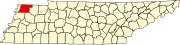 | |
| Towns | ||
| Unincorporated communities | ||
| Footnotes | ‡This populated place also has portions in an adjacent county or counties | |
| International | |
|---|---|
| National | |