L'Isle-aux-Coudres
L'Isle-aux-Coudres | |
|---|---|
 Ferries at the river station dock, chemin de la Traverse, Saint-Bernard-sur-Mer, 2004 | |
 Location within Charlevoix RCM | |
 L'Isle-aux-Coudres Location in central Quebec | |
| Coordinates: 47°24′N 70°23′W / 47.400°N 70.383°W | |
| Country | |
| Province | |
| Region | Capitale-Nationale |
| RCM | Charlevoix |
| Settled | 1728 |
| Constituted | August 23, 2000 |
| Government | |
| • Mayor | Dominic Tremblay |
| • Federal riding | Montmorency—Charlevoix —Haute-Côte-Nord |
| • Prov. riding | Charlevoix–Côte-de-Beaupré |
| Area | |
| • Total | 97.10 km2 (37.49 sq mi) |
| • Land | 30.16 km2 (11.64 sq mi) |
| Population (2016) | |
| • Total | 1,143 |
| • Density | 37.9/km2 (98/sq mi) |
| • Pop 2011-2016 | |
| • Dwellings | 754 |
| Time zone | UTC−5 (EST) |
| • Summer (DST) | UTC−4 (EDT) |
| Postal code(s) | |
| Area code(s) | 418 and 581 |
| Highways | No major routes |
| Website | www |
L'Isle-aux-Coudres, is a municipality located on island aux Coudres, in the St. Lawrence River, in Charlevoix Regional County Municipality, Capitale-Nationale region, Quebec, Canada.
Variations of the official name are: La Baleine, L'Île-aux-Coudres, Saint-Bernard-de-l'Île-aux-Coudres and Saint-Louis-de-l'Isle-aux-Coudres. Locally, the following variants are also noted: Île aux Coudriers, Île Elbow, Île aux Marsouins and Île aux Socles.
Access to the island are by sea (ferry) and air (airport).[1]'[2]' [3]'[4]
History
St Lawrence River
In canoes, made of birch bark or carved out of a tree trunk, First Nations have crisscrossed the St. Lawrence River from west to east, from the Great Lakes to the Atlantic Ocean and all the rivers of the Americas, from north to south, from the Arctic to Tierra del Fuego, for millennia. Indigenous peoples knew the advantages, irritants, barriers and dangers of waterways long before the arrival of Europeans and Jacques Cartier (1491-1557).[5]' [6]'
In North America, during the French regime (1534-1763), several shipwrecks marked the history of navigation on the St. Lawrence River. A path of discovery, a route of transport and settlement, an axis of trade and development, a privileged navigable route, little known, perilous and difficult, sailors did not venture on the St. Lawrence at nightfall, neither before the beginning of May nor after the end of November.
This river, which the Amerindians called "the walking way," is feared, and rightly so. On the route of conquerors, explorers, fishermen, hunters, adventurers, and other navigators, it is by entering the waters of the river that the most difficult operation of the journey begins. The shallowness of some channels, estuary reefs, shoals, diagonal currents, fog and the presence of narrow, winding channels, winter and ice are challenges that must be overcome.[7]
Botany
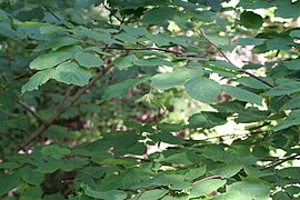
On September 6, 1535, during his second voyage to North America, the navigator Jacques Cartier named the island "couldres", after a hazel tree, a shrub abundant in the area.
Botany: Hazelwood - Sew. — Corylus cornuta Marshall. — Noisetier à long bec. — (Beaked hazelnut). Our hazelnut tree has very flexible stems, which can be used as ties, and an astringent and feverish bark. Its wood was used by dowsers to discover underground water sources (a matter of debate).
In 1928, the Historic Sites and Monuments Board of Canada erected a monument commemorating the anchorage of Cartier's 3 ships and the celebration of the first mass in the interior of Canada, at Saint-Bernard-sur-Mer, on a site donated by Ulysses and Élie José Dufour. [8]'
Geography
The island is about 11 kilometres (6.8 mi) long and averages 3 kilometres (1.9 mi) in width. It is thought to have been formed from material lifted up by the impact of the meteor which formed the Charlevoix region. Local streams include the Rouge River and Mare Creek.
- Pearl Bog Inc., 350 Traverse Road, 1976
-
 Peat bog and peat to dry
 -
 Peat bog and peat to dry, visitors to the island, N. Ouellette, L. Campbell, M. Proulx
 -
 Peat bog and peat to dry, visitor to the island, G. Lapointe


- Canot - Plan - Couldres - Historic monument
-

-
 Plan of the island in 1751
 -
 Corylus cornuta Marshall. — Noisetier à long bec. — (Beaked hazelnut).
 -
 Historic monument, Parc Canada, 1928, Saint-Bernard-sur-Mer


Whereas the modern French spelling for "island" is île, the municipality uses the old French spelling of Isle. Its population centres include La Baleine in the north-east, (Saint-Louis-de-)l'Isle-aux-Coudres in the south, and Saint-Bernard-sur-Mer in the north-west facing Baie-Saint-Paul. A free ferry service connects Saint-Bernard-sur-Mer to Saint-Joseph-de-la-Rive on the north shore of the gulf.
Formerly, porpoise fishing was practiced on a broad basis, supplemented by some boat construction. Today tourism is the main industry, and the place is known for its historical sites, tourist accommodations, and craftspeople. On the beach near the ferry dock, there is a shipyard that is home to craftsmen who work according to ancestral techniques. The island is also a popular destination for cyclists.
It was the setting for the classic 1963 National Film Board of Canada documentary Pour la suite du monde.
Étienne de Lessart of Ste. Anne-de-Beaupré was granted title as the first Seigneur of l'Isle-aux-Coudres by Governor Buade de Frontenac on March 4, 1677. Due to a failure to develop the property to increase its value he was forced to sell the seigneurie on October 19, 1687 to the Séminaire de Québec who began to establish a monastery on the site.[9] On October 29, 1687, Governor Denonville and Intendant Champigny granted the island as a seignory to the Seminary of Quebec, an act that was ratified on March 1, 1688.[10]
In 1728, the first concessions of land were granted to settlers, and by 1741, the Parish of Saint-Louis-de-France was formed, soon after renamed to Saint-Louis-de-l'Isle-aux-Coudres. Named after Louis IX of France, it probably was also a tribute to Louis Chaumont (or Chaumonot) de La Jaunière (ca. 1700-1776), priest of Baie-Saint-Paul from 1736 to 1767. In 1845, the Parish Municipality of Saint-Louis-de-l'Isle-aux-Coudres was formed. In 1847, it was abolished, but reestablished in 1855, and would remain the only municipality covering the entire island for the next 80 years.
The community of Saint-Bernard-sur-Mer, first known as Pointe-des-Roches until 1936, only really developed from 1902 onward. The Parish of Saint-Bernard, named in honour of Bernard of Clairvaux (ca. 1090-1153), was officially founded in 1934 when it separated from the Parish of Saint-Louis, and was incorporated as the Municipality of Saint-Bernard-de-l'Île-aux-Coudres in 1936.
In 1951, the Municipality of La Baleine was incorporated, when it separated from Saint-Louis-de-l'Isle-aux-Coudres. It was named after an incident that had occurred in the late 18th century when the islanders found a carcass of a dead whale (in French: baleine) that had stranded on the island's flats. At this point, the island was divided into three municipal entities. [2]'
On January 5, 1994, the Municipality of Saint-Bernard-de-l'Île-aux-Coudres and the Parish Municipality of Saint-Louis-de-l'Isle-aux-Coudres were merged and formed the Municipality of L'Île-aux-Coudres (new spelling). On August 23, 2000, this municipality and the Municipality of La Baleine were merged again to form the new Municipality of L'Isle-aux-Coudres (old spelling).
Photos
The locale is described as having "salty air, hair-raising winds, spectacular landscapes, horizons changing with the tides, seasons, spectacular sunrises and sunsets"[11]' [12]' [13]' [14]' [15]' [16]
- Charlevoix, maritime section of the St. Lawrence River 1976 - 2004
-
 Les Éboulements (Municipality), L'Assomption-de-la-Vierge parish, from the ferry to the island
 -
 The sea, pouring rain and crazy winds, Chemin des Coudriers
 -
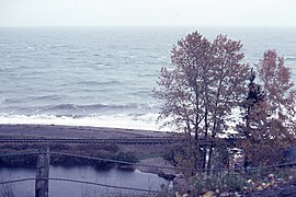
 The coast of Charlevoix, the St. Lawrence River, seen from the Pointe du Bout d'en Bas
 -
 Statue of Our Lady of the Assumption, erected in 1960 by Horace Pedneault, Pointe du Bout d'en Bas


- Chemin du Moulin - Chemin des Coudriers 1976
-
 Old Desgagné-de-L'Isle-aux-Coudres windmill, 247 chemin du Moulin
 -
 Chemin des Coudriers
 -
 Former 1st Saint-Louis Catholic Cemetery, closed in 1926
 -
 Catholic Processional Chapel and Cemetery
 -
 Saint-Isidore Processional Chapel, Chemin des Coudriers


- Maritime Heritage 1976
-
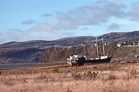 St. Lawrence schooner, in a field
 -

-
 In the captain's cabin, on the ferry to L'Isle-aux-Coudres
 -
 Engraved propeller: Lloyds 3749 - Nikalium - MB & BC etc., on the ferry
 -
 Captain in his cabin on the ferry


Note: Built in 1971, the Pointe de la Prairie lighthouse-pilar, on L'Isle-aux-Coudres, is exposed to extremely severe environmental conditions: salt water, continuous freeze-thaw cycles, impact from ice flows, that have contributed over the years to severe deterioration of the concrete that makes up the base of the lighthouse.[17]
Demographics

Population trend:
- Population in 2016: 1143 (2011 to 2016 population change: -10.6%)
- Population in 2011: 1279 (2006 to 2011 population change: -1.3%)
- Population in 2006: 1296
- Population in 2001: 1319
- Population in 1996:
- L'Ile-aux-Coudres (municipality): 1066
- La Baleine (municipality): 279
- Population in 1991:
- L'Ile-aux-Coudres (municipality): 1101
- La Baleine (municipality): 282
Private dwellings occupied by usual residents: 551 (total dwellings: 754)
Mother tongue:
- French as first language: 98.3%
- English as first language: 0.9%
- English and French as first language: 0.4%
- Other as first language: 0.9%
See also
References
- ^ "L'Isle-aux-Coudres (Municipalité)". Commission de toponymie Quebec (in French). Government of Quebec. 2000-11-09. Retrieved 2023-12-31.
Variations of official name: La Baleine, L'Île-aux-Coudres, Saint-Bernard-de-l'Île-aux-Coudres and Saint-Louis-de-l'Isle-aux-Coudres. Locally, there are also the following variants: Île aux Coudriers, Île Elbow, Île aux Marsouins and Île aux Socles.
- ^ a b "Island aux Coudres". Commission de toponymie Quebec (in French). Government of Quebec. 1968-12-05. Retrieved 2023-12-31.
It is because of the presence of couldres, the ancient name given to hazelnuts, that Cartier chose this name to designate the island
- ^ "Île aux Coudres Airport" (in French). 2023-12-31. Retrieved 2023-12-31.
Small airport whit one pist 17/35. pseudo-code OACI de CTA3
- ^ "Ferry L'Isle-aux-Coudres – Saint-Joseph-de-la-Rive". La Société des traversiers du Québec. 2023-12-31. Retrieved 2023-12-31.
Schedule
- ^ The Ages of Exploration. "Jacques Cartier". The Mariners' Museum and ParK. Retrieved 2024-01-13.
Jacques Cartier is credited with discovering and claiming the land now known as Canada for France.
- ^ "Île-aux-Coudres National Historic Event". Saint-Bernard-sur-Mer, Île-aux-Coudres, Quebec: Parks Canada, Directory of Federal Heritage Designations. 1928. Retrieved 2024-01-07.
On the 6th September, 1535, Jacques Cartier anchored his three ships near this place, explored the island, and named it Ile-aux-Coudres
- ^ Morgan Lowrie, The Canadian Press (2016-09-19). "Quebec researchers work to document lost shipwrecks of the St. Lawrence". CTV News. Retrieved 2024-01-16.
To create a list of all the shipwrecks on the St. Lawrence's north shore between Tadoussac and Anticosti Island, a 500-kilometre stretch of shoreline where she believes more than 800 boats went down.
- ^ John J. Furlow (5 November 2020). "Corylus cornuta subsp. cornuta". Flora of North America. Retrieved 2024-01-04.
Habitat: Moist to dry roadsides, edges of woods, fencerows, waste places, and thickets, or as understory in open woodlands
- ^ Lucien Gagné (1969). "Étienne de Lessard" (in French). Dictionnaire biographique du Canada. Retrieved 2024-01-08.
pioneer of the Côte de Beaupré, seigneur of Île-aux-Coudres and co-seigneur of Lanoraie
- ^ "Seigneurie de l'Île-aux-Coudres" (in French). Commission de toponymie du Québec. Retrieved 2010-05-07.
- ^ "L'Isle-aux-Coudres Coastal Committee" (pdf) (in French). Pointe du Bout d'en Bas, L'Isle-aux-Coudres: Integrated Management Plan for the Coastal Zone of Isle-aux-Coudres - Comité ZIP du Sud-de-l'Estuaire. 2007. pp. 59 of 96. Retrieved 2024-01-08.
Private land, on a natural site much frequented by locals and visitors.
- ^ "L'Isle-aux-Coudres - So much to do & admire". Tourisme Isle-aux-Coudres. Retrieved 2024-01-05.
23 km of a road lined with wildflowers or frozen tidal flats. It's some 1400 "marsouins", friendly nickname given to its inhabitants,
- ^ Monique Bellemare. "Moulin Desgagnés (L'Isle-aux-Coudres)". Quebec's Windmills, photos (in French). Retrieved 5 January 2024.
Built with the parts of an old mill dating back to 1763. Restored in 1944, 1961 and 1993.
- ^ Lorraine Guay (24 September 2022). "Marine Cemeteries of the St. Lawrence" (in French). Funerary and Commemorative Heritage Ecomuseum. Retrieved 2024-01-05.
you have to deal with many elements: winds, currents, tides, fog, ice in the spring and rapids, not to mention the many obstacles to navigation such as the shoals and reefs near the islands.
- ^ A Federal, Provincial and Territorial Collaboration. "St. Isidore's Processional Chapel" (in French and English). Canada's Historic Places. Retrieved 2024-01-05.
The architecture of the processional chapels was inspired by that of the churches, but it adopted a simpler plan and a more uncluttered workmanship.
- ^ "Rehabilitation of the Pointe de la Prairie Light House" (PDF). Canadian Coast Guard, QC. 2016-05-26. Retrieved 2024-01-04.
This challenging shotcrete rehabilitation project was successfully completed on time despite the difficult weather conditions that disrupted shooting schedules
External links
| Cities & towns | |
|---|---|
| Municipalities | |
| Parishes | |
| Unorganized territories | |
| |
| International | |
|---|---|
| National | |
| Geographic | |