Indiana statistical areas
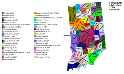
An enlargeable map of the 41 core-based statistical areas in Indiana .[1] The U.S. state of Indiana statistical areas that have been delineated by the Office of Management and Budget (OMB). On March 6, 2020, the OMB delineated ten combined statistical areas , 15 metropolitan statistical areas , and 26 micropolitan statistical areas in Indiana.[1]
Statistical areas The Office of Management and Budget (OMB) has designated more than 1,000 statistical areas for the United States and Puerto Rico .[2] United States Census Bureau , planning organizations, and federal, state, and local government entities.
The OMB defines a core-based statistical area (commonly referred to as a CBSA ) as "a statistical geographic entity consisting of the county or counties (or county-equivalents ) associated with at least one core[a] [2] metropolitan statistical areas (MSAs) that have "a population of at least 50,000" and micropolitan statistical areas (μSAs) that have "a population of at least 10,000, but less than 50,000."[2]
The OMB defines a combined statistical area (CSA) as "a geographic entity consisting of two or more adjacent core-based statistical areas with employment interchange measures[b] [2] primary statistical areas (PSAs) include all combined statistical areas and any core-based statistical area that is not a constituent of a combined statistical area.
Table The table below describes the 51 United States statistical areas and 92 counties of the State of Indiana with the following information:[3]
The combined statistical area (CSA) as designated by the OMB.[1]
The CSA population according to 2019 US Census Bureau population estimates.[4]
The core based statistical area (CBSA)[2] [1]
The CBSA population according to 2019 US Census Bureau population estimates [4]
The county name
The county population according to 2019 US Census Bureau population estimates [4]
The Metropolitan Division name, if applicable[1]
The Metropolitan Division population according to 2019 US Census Bureau population estimates [4]
The 51 United States statistical areas and 92 counties of the State of Indiana
Combined Statistical Area
2019 Population
Core Based Statistical Area
2019 Population
County
2019 Population
Metropolitan Division
2019 Population
Indianapolis-Carmel-Muncie, IN CSA
2,457,286
Indianapolis-Carmel-Anderson, IN MSA
2,074,537
Marion County, Indiana
964,582
none
Hamilton County, Indiana
338,011
Hendricks County, Indiana
170,311
Johnson County, Indiana
158,167
Madison County, Indiana
129,569
Hancock County, Indiana
78,168
Morgan County, Indiana
70,489
Boone County, Indiana
67,843
Shelby County, Indiana
44,729
Putnam County, Indiana
37,576
Brown County, Indiana
15,092
Muncie, IN MSA
114,135
Delaware County, Indiana
114,135
Columbus, IN MSA
83,779
Bartholomew County, Indiana
83,779
New Castle, IN μSA
47,972
Henry County, Indiana
47,972
Seymour, IN μSA
44,231
Jackson County, Indiana
44,231
Crawfordsville, IN μSA
38,338
Montgomery County, Indiana
38,338
North Vernon, IN μSA
27,735
Jennings County, Indiana
27,735
Greensburg, IN μSA
26,559
Decatur County, Indiana
26,559
Chicago-Naperville, IL-IN-WI CSA 9,825,325 Chicago-Naperville-Joliet, IL-IN-WI MSA 9,458,539 Cook County, Illinois 5,150,233
Chicago-Naperville-Evanston, IL MD 7,122,725
DuPage County, Illinois 922,921
Will County, Illinois 690,743
McHenry County, Illinois 307,774
Grundy County, Illinois 51,054
Lake County, Illinois 696,535
Lake County-Kenosha County, IL-WI MD 866,096
Kenosha County, Wisconsin 169,561
Kane County, Illinois 532,403
Elgin, IL MD 766,290
Kendall County, Illinois 128,990
DeKalb County, Illinois 104,897
Lake County, Indiana
485,493
Gary, IN MD
703,428
Porter County, Indiana
170,389
Jasper County, Indiana
33,562
Newton County, Indiana
13,984
Ottawa, IL μSA
147,036
LaSalle County, Illinois 108,669
none
Bureau County, Illinois 32,628
Putnam County, Illinois 5,739
Michigan City-La Porte, IN MSA
109,888
LaPorte County, Indiana
109,888
Kankakee, IL MSA 109,862
Kankakee County, Illinois 109,862
Fort Wayne-Huntington-Auburn, IN CSA
639,669
Fort Wayne, IN MSA
413,263
Allen County, Indiana
379,299
Whitley County, Indiana
33,964
Kendallville, IN μSA
47,744
Noble County, Indiana
47,744
Auburn, IN μSA
43,475
DeKalb County, Indiana
43,475
Huntington, IN μSA
36,520
Huntington County, Indiana
36,520
Decatur, IN μSA
35,777
Adams County, Indiana
35,777
Angola, IN μSA
34,594
Steuben County, Indiana
34,594
Bluffton, IN μSA
28,296
Wells County, Indiana
28,296
South Bend-Elkhart-Mishawaka, IN-MI CSA 809,069 South Bend-Mishawaka, IN-MI MSA 323,613 St. Joseph County, Indiana
271,826
Cass County, Michigan 51,787
Elkhart-Goshen, IN MSA
206,341
Elkhart County, Indiana
206,341
Niles, MI MSA 153,401
Berrien County, Michigan 153,401
Warsaw, IN μSA
79,456
Kosciusko County, Indiana
79,456
Plymouth, IN μSA
46,258
Marshall County, Indiana
46,258
Louisville-Jefferson County-Elizabethtown-Scottsburg, KY-IN CSA 1,489,142 Louisville-Jefferson County, KY-IN MSA 1,265,108 Jefferson County, Kentucky 766,757
Clark County, Indiana
118,302
Bullitt County, Kentucky 81,676
Floyd County, Indiana
78,522
Oldham County, Kentucky 66,799
Shelby County, Kentucky 49,024
Harrison County, Indiana
40,515
Washington County, Indiana
28,036
Spencer County, Kentucky 19,351
Henry County, Kentucky 16,126
Elizabethtown, KY MSA 153,928
Hardin County, Kentucky 110,958
Meade County, Kentucky 28,572
LaRue County, Kentucky 14,398
Bardstown, KY μSA
46,233
Nelson County, Kentucky 46,233
Scottsburg, IN μSA
23,873
Scott County, Indiana
23,873
none
Evansville, IN-KY MSA 315,086 Vanderburgh County, Indiana
181,451
Warrick County, Indiana
62,998
Henderson County, Kentucky 45,210
Posey County, Indiana
25,427
Lafayette-West Lafayette-Frankfort, IN CSA
265,401
Lafayette, IN MSA
233,002
Tippecanoe County, Indiana
195,732
Carroll County, Indiana
20,257
Benton County, Indiana
8,748
Warren County, Indiana
8,265
Frankfort, IN μSA
32,399
Clinton County, Indiana
32,399
Bloomington-Bedford, IN CSA
214,600
Bloomington, IN MSA
169,230
Monroe County, Indiana
148,431
Owen County, Indiana
20,799
Bedford, IN μSA
45,370
Lawrence County, Indiana
45,370
none
Terre Haute, IN MSA
186,367
Vigo County, Indiana
107,038
Clay County, Indiana
26,225
Sullivan County, Indiana
20,669
Parke County, Indiana
16,937
Vermillion County, Indiana
15,498
Kokomo-Peru, IN CSA
118,060
Kokomo, IN MSA
82,544
Howard County, Indiana
82,544
Peru, IN μSA
35,516
Miami County, Indiana
35,516
Richmond-Connersville, IN CSA
88,986
Richmond, IN μSA
65,884
Wayne County, Indiana
65,884
Connersville, IN μSA
23,102
Fayette County, Indiana
23,102
Cincinnati-Wilmington-Maysville, OH-KY-IN CSA 2,280,246 Cincinnati, OH-KY-IN MSA 2,221,208 Hamilton County, Ohio 817,473
Butler County, Ohio 383,134
Warren County, Ohio 234,602
Clermont County, Ohio 206,428
Kenton County, Kentucky 166,998
Boone County, Kentucky 133,581
Campbell County, Kentucky 93,584
Dearborn County, Indiana
49,458
Brown County, Ohio 43,432
Grant County, Kentucky 25,069
Franklin County, Indiana
22,758
Pendleton County, Kentucky 14,590
Gallatin County, Kentucky 8,869
Bracken County, Kentucky 8,303
Union County, Indiana
7,054
Ohio County, Indiana
5,875
Wilmington, OH μSA 41,968
Clinton County, Ohio 41,968
Maysville, KY μSA 17,070
Maysville County, Kentucky
17,070
none
Marion, IN μSA
65,769
Grant County, Indiana
65,769
Jasper, IN μSA
55,125
Dubois County, Indiana
42,736
Pike County, Indiana
12,389
Logansport, IN μSA
37,689
Cass County, Indiana
37,689
Vincennes, IN μSA
36,594
Knox County, Indiana
36,594
Washington, IN μSA
33,351
Daviess County, Indiana
33,351
Madison, IN μSA
32,308
Jefferson County, Indiana
32,308
Wabash, IN μSA
30,996
Wabash County, Indiana
30,996
none
LaGrange County, Indiana
39,614
Gibson County, Indiana
33,659
Greene County, Indiana
31,992
Ripley County, Indiana
28,324
Randolph County, Indiana
24,665
White County, Indiana
24,102
Starke County, Indiana
22,995
Jay County, Indiana
20,436
Spencer County, Indiana
20,277
Fulton County, Indiana
19,974
Orange County, Indiana
19,646
Perry County, Indiana
19,169
Rush County, Indiana
16,581
Fountain County, Indiana
16,346
Tipton County, Indiana
15,148
Pulaski County, Indiana
12,353
Blackford County, Indiana
11,758
Switzerland County, Indiana
10,751
Crawford County, Indiana
10,577
Martin County, Indiana
10,255
State of Indiana
6,625,375
See also
Notes
^ The OMB defines a core as "a densely settled concentration of population, comprising an Urban Area (of 10,000 or more population) delineated by the Census Bureau , around which a core-based statistical area is delineated."[2]
^ The OMB defines the employment interchange measure as "the sum of the percentage of workers living in the smaller entity who work in the larger entity plus the percentage of employment in the smaller entity that is accounted for by workers who reside in the larger entity."[2]
References
^ a b c d e Revised Delineations of Metropolitan Statistical Areas, Micropolitan Statistical Areas, and Combined Statistical Areas, and Guidance on Uses of the Delineations of These Areas (March 6, 2020). "0MB BULLETIN NO. 20-01" (PDF) . Office of Management and Budget . Retrieved December 13, 2021 . {cite web }: CS1 maint: multiple names: authors list (link )^ a b c d e f g "2020 Standards for Delineating Core Based Statistical Areas" . Office of Management and Budget . July 16, 2021. Retrieved December 13, 2021 .^ An out-of-state area and its population are displayed in green. An area that extends into more than one state is displayed in teal. A teal population number over a black population number show the total population versus the in-state population.^ a b c d "Annual Estimates of the Resident Population for Counties in the United States: April 1, 2010 to July 1, 2019" . United States Census Bureau , Population Division. April 2020. Retrieved April 9, 2020 .
External links
39°53′39″N 86°16′54″W / 39.8942°N 86.2816°W / 39.8942; -86.2816 (State of Indiana )
 Media from Commons
 News from Wikinews
 Travel information from Wikivoyage