Jubail, Saudi Arabia
Jubail
الجبيل | |
|---|---|
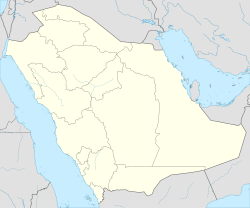
| Coordinates: 27°00′00″N 49°39′16″E / 27.00000°N 49.65444°E | |
| Country | |
| Province | Eastern Province |
| Government | |
| • Type | Monarchy |
| • Provincial Governor | Saud bin Nayef |
| Population (2022) | |
• City | 474,679 |
| • Metro | 505,162 (Jubail governorate) |
| • Nationality (2011) | 73% Saudi 17% Indian 4% Filipinos 3% Pakistanis 1% Bangladeshis 1% Americans 1% Europeans 2.5% Other countries |
| Time zone | UTC+3 (AST) |
| Website | www |

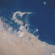
Jubail (Arabic: الجبيل, Al Jubayl) is a city in the Eastern province on the Arabian Gulf coast of Saudi Arabia, with a total population of 474,679 as of 2022. It is home to one of the largest industrial cities in the world. It is also home to the Middle East's largest and world's fourth largest petrochemical company SABIC. It has the world's largest IWPP (Independent Water and Power Project) producing 2743.6 MW of electricity and 800,000 m3 of water daily.
Jubail comprises the Old Town of Al Jubail (Jubail Balad), which was a small fishing village until 1975, and the Industrial Area. Jubail Industrial City is the largest civil engineering project in the world today. In 1975, the Saudi government designated Jubail as the site for new industrial city, with rapid expansion and industrialization arising. The new industrial and residential areas were named Madīnat al Jubayl aṣ Ṣinā`īyah (Jubail Industrial City). The 2005 Census Report for Jubail Industrial City estimates the population at 224,430 residents.[1]
History
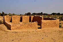
The town of Al-Jubail, on the Arabian Gulf coast of the Kingdom of Saudi Arabia, has ancient roots. Human habitation dates back at least 7,000 years, when the people of Dilmun — whose civilization radiated up and down the coast of the Arabian Gulf — established a settlement there. Archaeological place: Crease Tower or Tuwayah Tower was constructed around 1928. It was key source of water for Jubail. In September 1933, Jubail gained a measure of fame as the landing site for the first team of geologists to explore for oil in Saudi Arabia.[2]
Jubail Industrial City
It is the world's largest industrial city established in 1975. It covers 1,016 square kilometers and includes industrial complexes, major harbour and port facilities. It contributes to about 7% of Saudi Arabia's GDP.[3]
Bechtel began work on the Jubail Industrial City project more than 40 years ago and is still working in Jubail now. Bechtel has managed the Jubail project since it began in the mid-1970s, and in 2004 the Royal Commission for Jubail and Yanbu asked the company to manage Jubail II, a $3.8 billion expansion of the city's industrial and residential areas.


Transportation
Highway
Jubail is directly connected with other cities by two major highways; Dhahran-Jubail Highway and Abu Hadriyah Highway.
One ongoing project is the Jubail-Qassim (Buraidah) Expressway 500 km (310 mi), which will reduce the distance between Jubail and Qassim (Buraidah) to around 331 km (206 mi) from the current 831 km (516 mi).
Railway
A branch of the Saudi Landbridge Project railway is proposed to connect Jubail to Dammam.
Seaport
There are two seaports in Jubail—the Jubail Commercial Seaport and the King Fahd Industrial Seaport. As of 2011, Jubail ranks 92nd in the world in terms of Total Cargo Volume with 44,700 tons.[4]
Airport
The city is served by King Fahd International Airport.
Jubail Naval Airport is an airfield 25 kilometres (16 mi) west of Jubail City, near the industrial area. Originally constructed by the Royal Commission of Jubail and Yanbu as part of Jubail project, it was meant to be used for commercial aviation until it was decided to utilize the large nearby King Fahd International Airport. Thus, it was handed over to the Ministry of Defence and has been used as a base for the naval aviation group/eastern fleet of the Royal Saudi Navy since then. The terminal in Dammam Airport is about 60 km drive from the suburbs of Jubail, 80 km from the city center and 100 km from the Royal Commission neighborhoods.
However it was recently announced that the airport will be opened for private aviation operations starting September 2014. A project to renovate the airfield was undertaken since some of the airfield's infrastructure was incomplete, as a result of the previous change for the use of airport from commercial to military. To date, the project and renovations have not been completed.
In addition, two other airfields are located in the city; Abu Ali Airport is located in the Island of Abu Ali while the other is located in King Abdulaziz Naval Base.
Main sights


Jubail has a robust market place, known as International Market. It also has several malls, such as Fanateer Mall, Galleria Mall, Jubail Center Mall, Fanateer Beach, City Max, Hyper-Panda, Panda, Banana Beach, Jubail Centre, Home Center, Red Tag, Centrepoint, Jalmudah Hills, Jubail Plaza, Jubail RTV Riding Arena and Jubail Mall.[5]
Beaches
- Jubail Beach 27°00′34″N 49°40′04″E / 27.009401°N 49.667760°E
- Al Jubail Corniche 27°02′12″N 49°38′14″E / 27.036733°N 49.637234°E
- Youth Beach 27°05′12″N 49°35′19″E / 27.086615°N 49.588674°E
- Al Nakheel Beach 27°07′04″N 49°34′20″E / 27.117686°N 49.572271°E
- Fanateer Beach 27°08′40″N 49°34′02″E / 27.144392°N 49.567130°E
- Dareen Beach 27°10′27″N 49°34′12″E / 27.174105°N 49.569877°E
- Banana Beach
The Jubail desalination plant
As part of the industrial city, Jubail has a desalination plant called Saline Water Conversion Corp. (SWCC). In 2019, SWCC hit Guinness World Record as the largest producer of desalinated water worldwide. The plant hit the record as it produces 5.6 million cubic meters every day.[6]
Education
Schools
- Al Abna'a Schools
- Mariya international School[7]
- Dunes International School
- Al Moattasem International School
- Hafeez International School
- International Indian School, Al- Jubail (IIS Jubail)[8]
- ISG Jubail[9]
- Jubail Academy International School
- King Fahd High School
- Pakistan International School[10]
- Al Murjan Elementary School
- Al Ahsa Secondary School
- Andalus Elementary School
- Dana Elementary School
- Fanatir Elementary School
- Fayha Elementary School
- Khaleeg Intermediate School
- Al Deffi Secondary School
- Najd Secondary School
- Umm Alqurra Secondary School
- Zaid Bin Amr Elementary School
Universities and colleges

- Jubail Industrial College
- Jubail Technical Institute
- Jubail University College[11]
Hospitals, dispensaries and dental centers
- Al Fanateer Hospital
- Mohammed Suleiman Al Khonaini Medical Complex
- Al Khonaini Medical Complex
- Al-Fayadh Medical Clinic
- Al-Hijailan Medical Clinic
- Al-Shabani General Hospital
- Al-Shifa Hospital
- Almana General Hospital
- Almana Medical Center
- Al Naba Medical Complex
- Ar Razi Clinic
- Armed Forces Hospital
- Badr Al Khaleej Medical Center
- Danat Al Sahraa Medical Company (KIMS)
- Dina Dispensary for Medical Services
- Gulf Asian Medical Center
- Huda Younis Dental Complex
- Jubail General Hospital
- Jubail Medical Center (Mutlaq Al Otaibi Medical Service Group)
- Jubail National Dispensary
- KIMS Medical Center
- Kingdom Dental Medical Dispensary
- Lulu Dispensary
- Lulu Hospital
- Mayo Dental Center
- Mouwasat Hospital
- Ram Dental Complex
- Royal Commission Hospital
Eastern Province
- Safwa city: 56 km (35 mi)
- Qatif: 64 km (40 mi)
- Ras Tanura: 71 km (44 mi)
- Saihat: 76 km (47 mi)
- Dammam: 96 km (60 mi)
- Khobar: 104 km (65 mi)
- Abqaiq: 160 km (99 mi)
- Al-Ahsa: 222 km (138 mi)
Other provinces
- Riyadh: 510 km (320 mi)
- Buraydah: 768 km (477 mi)
- Arar: 967 km (601 mi)
- Ha'il: 938 km (583 mi)
- Medina: 1,263 km (785 mi)
- Mecca: 1,333 km (828 mi)
- Jeddah: 1,418 km (881 mi)
Other cities of Eastern Arabia
 Manama: 166 km (103 mi)
 Kuwait City: 342 km (213 mi)
 Doha: 496 km (308 mi)
 Abu Dhabi: 865 km (537 mi)
 Dubai: 977 km (607 mi)
 Muscat: 1,374 km (854 mi)
Climate
Jubail has a hot desert climate (Köppen climate classification BWh).
| Climate data for Jubail | |||||||||||||
|---|---|---|---|---|---|---|---|---|---|---|---|---|---|
| Month | Jan | Feb | Mar | Apr | May | Jun | Jul | Aug | Sep | Oct | Nov | Dec | Year |
| Mean daily maximum °C (°F) | 26.0 (78.8) |
32.0 (89.6) |
36.0 (96.8) |
41.0 (105.8) |
46.0 (114.8) |
48.0 (118.4) |
49.0 (120.2) |
50.0 (122.0) |
47.0 (116.6) |
44.0 (111.2) |
34.0 (93.2) |
29.0 (84.2) |
40.2 (104.3) |
| Daily mean °C (°F) | 15.7 (60.3) |
18.5 (65.3) |
23.0 (73.4) |
26.2 (79.2) |
32.5 (90.5) |
35.9 (96.6) |
37.6 (99.7) |
37.4 (99.3) |
34.5 (94.1) |
30.4 (86.7) |
23.9 (75.0) |
19.7 (67.5) |
27.9 (82.3) |
| Mean daily minimum °C (°F) | 8.0 (46.4) |
9.0 (48.2) |
13.0 (55.4) |
13.0 (55.4) |
20.0 (68.0) |
24.0 (75.2) |
27.0 (80.6) |
28.0 (82.4) |
22.0 (71.6) |
20.0 (68.0) |
14.0 (57.2) |
12.0 (53.6) |
17.5 (63.5) |
| Source: Wunderground King Fahad Airport (2023) | |||||||||||||
See also
References
- ^ "World's Largest Industrial Areas". WorldAtlas. Retrieved 2019-05-05.
- ^ "Vanguard at Jubail". Aramco World Digital Archive. November 1962. Archived from the original on 2024-04-21.
- ^ "Jubail Industrial City". MEED. 2017-05-01. Retrieved 2019-05-05.
- ^ "Ports & World Trade". www.aapa-ports.org. Retrieved 9 April 2018.
- ^ "Google Maps". Google Maps. Retrieved 9 April 2018.
- ^ "Saline Water corporation receives Guinness World Records". Arab News. 2019-02-21. Retrieved 2019-02-21.
- ^ "About us – Mariya International schools".
- ^ "IIS Jubail | Home". www.iisjubail.org.
- ^ "Welcome - ISG Jubail School". July 9, 2015. Archived from the original on 2015-07-09.
- ^ "Index of /". www.pisjubail.com.
- ^ "Jubail University College". www.ucj.edu.sa.
{}
- Royal Commission for Jubail and Yanbu Archived 2012-10-16 at the Wayback Machine
- Jubail City - Article about master planning the Jubail New Industrial City Archived 2011-02-08 at the Wayback Machine
- Jubail directory Archived 2017-12-09 at the Wayback Machine
- www.worldatlas.com
- zeenews.india.com


