Kabaena
 Kabaena | |
| Geography | |
|---|---|
| Location | South East Asia |
| Coordinates | 5°15′S 121°55′E / 5.250°S 121.917°E |
| Area | 894.15 km2 (345.23 sq mi) |
| Administration | |
| Province | |
| Demographics | |
| Population | 47,071 (mid 2023 estimate) |
| Pop. density | 52.6/km2 (136.2/sq mi) |
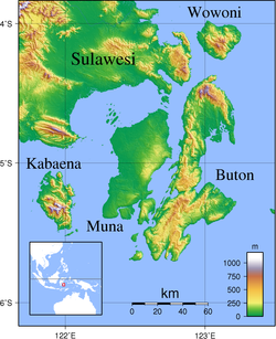
Kabaena or Tokotua is an island in the Flores Sea, Indonesia, off the coast of Sulawesi. Most of it is a part of Bombana Regency within Southeast Sulawesi province, although the southernmost district (Talaga Raya) is administratively part of Central Buton Regency. The island's area is 894.15 km2 and its total population at the 2010 Census was 35,558[1] and at the 2020 Census was 42,877;[2] the official estimate as at mid 2023 was 47,071.[3]
Administrative Districts
The island includes six of the 22 districts of Bombana Regency, and one district of Central Buton Regency. These seven districts are tabulated below with their areas and their populations at the 2010 Census[1] and the 2020 Census,[2] together with the official estimates as at mid 2023.[3] The table also includes the administrative centre of each district, the number of administrative villages (rural desa and urban kelurahan) and small offshore islands in each district, and its post code.
| Name of District (kecamatan) |
Area in km2 |
Pop'n Census 2010 |
Pop'n Census 2020 |
Pop'n Estimate mid 2023 |
Admin centre |
No. of villages |
No. of islands |
Post code |
|---|---|---|---|---|---|---|---|---|
| Kabaena Utara (North Kabaena) |
125.49 | 3,671 | 4,031 | 4,634 | Tedubara | 6 | 4 | 93785 |
| Kabaena Barat (West Kabaena) |
49.81 | 7,492 | 7,829 | 8,422 | Baliara | 5 | 7 | 93780 |
| Kabaena | 101.05 | 2,849 | 3,120 | 3,322 | Teomokole | 4 | - | 93781 |
| Kabaena Selatan (South Kabaena) |
120.04 | 2,606 | 3,325 | 3,536 | Batuawu | 4 | - | 93782 |
| Kabaena Tengah (Central Kabaena) |
288.61 | 3,254 | 4,064 | 5,001 | Lengora | 7 | - | 93783 |
| Kabaena Timur (a) (East Kabaena) |
119.66 | 6,663 | 7,566 | 8,438 | Dongkala | 7 | 2 | 93784 |
| Talaga Raya (b) | 89.49 | 9,023 | 12,942 | 13,718 | Talaga Satu | 7 | 5 | 93766 |
| (Total of Kabaena Island) | 894.15 | 35,558 | 42,877 | 47,071 | 40 | 18 |
Note: (a) Includes the offshore islands of Damalawa Besar and Damalawa Kecil. (b) Talaga Raya District comprises the southern part of Kabaena Island together with two smaller islands off its south-east coast - Talaga Besar (Great Talaga) and Talaga Kecil (Little Talaga); some 70% of the district's population inhabit Talaga Kecil, which contained 9,360 inhabitants (at the mid 2022 estimate) in its area of 3.29 km2.
Villages
The island's 40 villages (rural desa and urban kelurahan) are listed below with their areas and their populations at the 2020 Census.[2] Six of the 40 villages (indicated by asterisks below) have the status of kelurahan, while the other 34 are desa.
Within Talaga Raya District, the kelurahan of Talaga I plus the first three desa (Talaga II, Liwu Lompona and Pangilia) constitute the 3.29 km2 area of Talaga Kecil Island with 70% of the district population, while the other three desa (Kokoe, Wulu and Talaga Besar) constitute the 86.07 km2 area on Kabaena Island itself and on Talaga Besar Island with 30% of the district population.
References