Kfarhata
Kfarhata
كفرحاتا | |
|---|---|
City | |
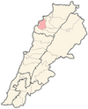
 Kfarhata Location within Lebanon | |
| Coordinates: 34°17′0″N 35°45′0″E / 34.28333°N 35.75000°E | |
| Country | |
| Governorate | North Governorate |
| District | Koura District |
| Elevation | 170 m (560 ft) |
| Time zone | UTC+2 (EET) |
| • Summer (DST) | UTC+3 (EEST) |
| Dialing code | +961 |
Kfarhata (Arabic: كفرحاتا), also known as Kfar Hata or Kafrhata, is a village located in the Koura District, in the North Governorate of Lebanon. It is one of the 52 towns of El-Koura, situated at the southern region of this district, at the other side of Al-Kateh (The cutter), a shallow but wide valley, separating a group of 6 towns from the gigantic El-Koura olive plains. In 1953, Kfarhata had a population of 590 living in 64 households.[1]
Demographics
In 2014, Christians made up 97.84% of registered voters in Kfarhata. 77.53% of the voters were Greek Orthodox and 18.25% were Maronite Catholics.[2]
Landscape
Although the mountainous profile of this town, the olive trees cultivation is equally successful and popular, with high quality of olive oil, extracted with the traditional Koranian cold technique.
-
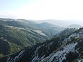 El-Koura "Cutter" (Western view)
 -
 El-Koura "Cutter" (Eastern view)


See also
References
- ^ Sawaya, Salah Michel (March 1953). Household Income and Expenditure in Al-Kura, Lebanon (PDF). Scholarworks (M.A.). Beirut, Lebanon: Economics Dept., American University of Beirut, Lebanon. hdl:10938/3411. Archived from the original (PDF) on 24 March 2023. Retrieved 2023-03-24.
- ^ https://lub-anan.com/المحافظات/الشمال/الكورة/كفرحاتا/المذاهب/
External links
- Kfar Hata, Localiban