Kula, Croatia
Kula | |
|---|---|
Village | |
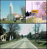 Kula images | |
 Kula | |
| Coordinates: 45°22′54″N 17°53′49″E / 45.38167°N 17.89694°E | |
| Country | |
| Region | Požega Valley, Slavonia |
| County | |
| City | Kutjevo |
| Area | |
| • Total | 7.7 km2 (3.0 sq mi) |
| Elevation | 160 m (520 ft) |
| Population (2021)[2] | |
| • Total | 249 |
| • Density | 32/km2 (84/sq mi) |
| Time zone | UTC+1 (CET) |
| • Summer (DST) | UTC+2 (CEST) |
| Postal code | 34343 |
| Area code | 034 |
Kula (German: Josefsfeld) is a village in Požega-Slavonia County, Croatia. The village is administered as a part of the city of Kutjevo. According to national census of 2011, population of the village is 331.[3] The village is connected by the D51 state road.
Sources
- ^ Register of spatial units of the State Geodetic Administration of the Republic of Croatia. Wikidata Q119585703.
- ^ "Population by Age and Sex, by Settlements, 2021 Census". Census of Population, Households and Dwellings in 2021. Zagreb: Croatian Bureau of Statistics. 2022.
- ^ "Population by Age and Sex, by Settlements, 2011 Census: Kula". Census of Population, Households and Dwellings 2011. Zagreb: Croatian Bureau of Statistics. December 2012.