Lair Point

Lair Point is a point projecting 570 m into Barclay Bay from Robbery Beaches on Byers Peninsula, Livingston Island in the South Shetland Islands, Antarctica and forming the east side of the entrance to Kukuzel Cove. Dominated by Lair Hill (96 m).
The point is named descriptively from a large cave on the point used by the early 19th century sealers, relics of whose occupation were found by the Falkland Islands Dependencies Survey in 1957–58.
Location
The point is located at 62°36′54″S 61°02′07″W / 62.61500°S 61.03528°W which is 1.16 km east-southeast of Villard Point and 2.94 km west of Nedelya Point (British mapping in 1968, detailed Spanish mapping in 1992, and Bulgarian mapping in 2005 and 2009).
Maps
- Península Byers, Isla Livingston. Mapa topográfico a escala 1:25000. Madrid: Servicio Geográfico del Ejército, 1992.
- L.L. Ivanov et al. Antarctica: Livingston Island and Greenwich Island, South Shetland Islands. Scale 1:100000 topographic map. Sofia: Antarctic Place-names Commission of Bulgaria, 2005.
- L.L. Ivanov. Antarctica: Livingston Island and Greenwich, Robert, Snow and Smith Islands. Scale 1:120000 topographic map. Troyan: Manfred Wörner Foundation, 2009. ISBN 978-954-92032-6-4
- Antarctic Digital Database (ADD). Scale 1:250000 topographic map of Antarctica. Scientific Committee on Antarctic Research (SCAR). Since 1993, regularly upgraded and updated.
- L.L. Ivanov. Antarctica: Livingston Island and Smith Island. Scale 1:100000 topographic map. Manfred Wörner Foundation, 2017. ISBN 978-619-90008-3-0
Gallery
-
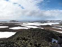
 Eastern Byers Peninsula in Livingston Island with left to right Lair Hill, Robbery Beaches, Sparadok Point, Tsamblak Hill and Negro Hill in the middle ground; and Rowe Point, Cutler Stack, Ivanov Beach, Nedelya Point, Urvich Wall surmounted by the slopes of Rotch Dome, and Clark Nunatak in the background
 -
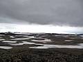
 Map of Antarctic Specially Protected Area ASPA 126 Byers Peninsula
 -
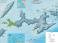 Topographic map of Livingston Island and Smith Island


References