Landmannalaugar
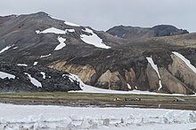


Landmannalaugar (Icelandic pronunciation: [ˈlantˌmanːaˌlœyːɣar̥] ⓘ) is a location in Iceland's Fjallabak [ˈfjatlaˌpaːk] Nature Reserve in the Highlands.[1] It is on the edge of the Laugahraun [ˈlœyːɣaˌr̥œyːn] lava field. This lava field was formed by an eruption in approximately 1477.[2] It is largely known for its natural geothermal hot springs and surrounding landscape.
Landmannalaugar is at the northern end of the Laugavegur hiking trail, and the Iceland Touring Association operates a mountain hut accommodating hikers.[3] During the high tourist season, a small shop and a horse tour agency operate there, as well as the ICE-SAR highland patrol in Fjallabak. Several bus companies have regular trips to and from Landmannalaugar during the tourist season.
Routes
Four routes lead to Landmannalaugar. Only one is reachable by car, though the road is rough and only accessible to four-wheel drive vehicles. There are also roads leading to Landmannalaugar from the east via Eldgjá, or the north via Sprengisandur. Both are four-wheel drive roads only.
Activities
Hiking
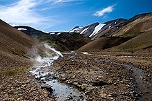
Landmannalaugar is known for its hiking trails. Some routes include the hike through the Laugahraun [ˈlœiːɣaˌr̥œiːn] lava field to Brennisteinsalda ("Sulphur Wave"), the one-hour hike up Bláhnjúkur ("Blue Peak"), and the four-hour hike to Ljótipollur [ˈljouːtɪˌpʰɔtlʏr̥] crater lake ("Ugly Puddle"). Landmannalaugar can also be the starting point of several longer hiking trails, such as the Hellismannaleið [ˈhɛtlɪsˌmanːaˌleiːθ] route at the base of the Hekla volcano, and the Sprengisandur route for hikers prepared to travel through volcanic desert.
Landmannalaugar is the usual starting point for a four-day-long hiking trail called Laugavegur, meaning "The Landmannalaugar Trail"—"Laugar" being a shortened version of "Landmannalaugar". The standard four-day hike ends in Thórsmörk, but one or two days can be added to trek to Skógar near the coast via Fimmvörðuháls between the two glaciers, Eyjafjallajökull and Mýrdalsjökull.
The huts on the Laugavegur and Fimmvörðuháls trails are (from north to south):
- Landmannalaugar
- Hrafntinnusker
- Álftavatn
- Hvanngil
- Emstrur
- Thórsmörk
- Fimmvörðuháls
Other activities
Icelandic horse riding has been available in the area each summer. The horse riding trips visit places such as Jökulgil [ˈjœːkʏlˌcɪːl̥] (Glacier Valley), that can often be difficult to access on foot and are inaccessible by car. Arctic char fishing is a common activity in Landmannalaugar and nearby lakes. Geothermal hot springs are also present in the area and can be publicly used for bathing.[4] Cross-country skiing often takes place in the area during the winter.[5]
See also
References
- ^ "Auglýsing um friðland að Fjallabaki". Stjórnartíðindi B, nr. 354/1979. August 13. 1979. Retrieved on August 21. 2014. (in Icelandic)
- ^ Sigurður Steinþórsson. "Í hvaða gosi myndaðist hraunið hjá Landmannalaugum og hvaða ár?". The Icelandic Web of Science July 4. 2008. Retrieved on 21 August 2014. (in Icelandic)
- ^ "LANDMANNALAUGAR HUT" Archived 2007-10-08 at the Wayback Machine Retrieved on 21 August 2014.
- ^ "5 Things to know about the Landmannalaugar region". Icelandmag. Retrieved 2022-11-17.
- ^ "Landmannalaugar Cross Country Skiing Tour | Icelandic Mountain Guides". Mountainguides.is. Retrieved 2016-08-21.
External links
Information:
- The official Landmannalaugar information site
- Description, map view, and track download of the Laugavegur and Fimmvörðuháls trails (south to north)
Photos:
- Mountains near Landmannalaugar
- Coming down laugarvegur from Hrafntinnusker
- Laugarvegur, in the foreground Brennisteinsalda, right-hand side in the middle ground, Bláhnjúkur
- The campground of Landmannalaugar
- Panoramic virtual tour of Landmannalaugar
Videos:
63°58′59″N 19°04′01″W / 63.983°N 19.067°W
| International | |
|---|---|
| National | |