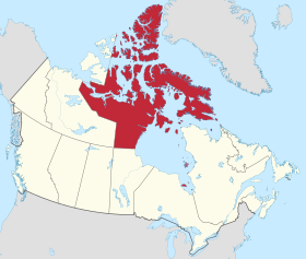
List of communities in Nunavut
Communities in Canada's provinces and territories
This is a list of communities in Nunavut , Canada . Many of these communities have alternate names or spellings in Inuktitut or Inuinnaqtun , while others are primarily known by their Inuktitut or Inuinnaqtun names. As of the 2016 census the population of Nunavut was 35,944, an increase of 12.66% from the 2011 census .[ 1]
Communities
The following are communities recognised by the Government of Nunavut.
Community[ 2]
Inuktitut /Inuinnaqtun [ 3] Inuktitut syllabics
Translation[ 2]
Region
2021 Census of Population [ 4] Location
2021
2016
% change
Arctic Bay
Ikpiarjuk[ 5]
ᐃᒃᐱᐊᕐᔪᒃ
the pocket[ 5]
Qikiqtaaluk Region
994
868
+14.5
73°02′11″N 085°09′09″W / 73.03639°N 85.15250°W / 73.03639; -85.15250 (Arctic Bay )
Arviat
ᐊᕐᕕᐊᑦ
bowhead whale [ 6] Kivalliq Region
2,864
2,657
+7.8
61°06′29″N 094°03′25″W / 61.10806°N 94.05694°W / 61.10806; -94.05694 (Arviat )
Baker Lake
Qamani’tuaq[ 7]
ᖃᒪᓂᑦᑐᐊᖅ
big lake joined by a river at both ends
Kivalliq Region
2,061
2,069
-0.4
64°19′05″N 096°01′03″W / 64.31806°N 96.01750°W / 64.31806; -96.01750 (Baker Lake )
Bathurst Inlet c Qingaut
ᕿᙵᐅᓐ
the nose
Kitikmeot Region
0
0
N/A
66°50′00″N 108°02′00″W / 66.83333°N 108.03333°W / 66.83333; -108.03333 (Bathurst Inlet )
Cambridge Bay
Iqaluktuuttiaq[ 8]
ᐃᖃᓗᒃᑑᑦᑎᐊᖅ
a good place with many fish[ 8]
Kitikmeot Region
1,760
1,766
-0.3
69°07′02″N 105°03′11″W / 69.11722°N 105.05306°W / 69.11722; -105.05306 (Cambridge Bay )
Chesterfield Inlet
Igluligaarjuk[ 9]
ᐃᒡᓗᓕᒑᕐᔪᒃ
place with a few igloos (houses)[ 9]
Kivalliq Region
397
437
-9.2
63°20′27″N 090°42′22″W / 63.34083°N 90.70611°W / 63.34083; -90.70611 (Chesterfield Inlet )
Clyde River
Kangiqtugaapik[ 10]
ᑲᖏᖅᑐᒑᐱᒃ
nice little inlet[ 10]
Qikiqtaaluk Region
1,181
1,053
+12.2
70°28′26″N 068°35′10″W / 70.47389°N 68.58611°W / 70.47389; -68.58611 (Clyde River )
Coral Harbour
Salliq[ 11]
ᓴᓪᓖᑦ
a large, flat island in front of the mainland[ 11]
Kivalliq Region
1,035
891
+16.2
64°08′13″N 083°09′51″W / 64.13694°N 83.16417°W / 64.13694; -83.16417 (Coral Harbour )
Gjoa Haven
Uqsuqtuuq[ 12]
ᐅᖅᓱᖅᑑᖅ
place of plenty of fat (blubber)[ 12]
Kitikmeot Region
1,349
1,324
+1.9
68°37′33″N 095°52′30″W / 68.62583°N 95.87500°W / 68.62583; -95.87500 (Gjoa Haven )
Grise Fiord
Aujuittuq[ 13]
ᐊᐅᔪᐃᑦᑐᖅ
place that never thaws[ 13]
Qikiqtaaluk Region
144
129
+11.6
76°25′03″N 082°53′38″W / 76.41750°N 82.89389°W / 76.41750; -82.89389 (Grise Fiord )
Igloolik
Iglulik
ᐃᒡᓗᓕᒃ
place of iglus [ 14] a
Qikiqtaaluk Region
2,049
1,744
+17.5
69°22′34″N 081°47′58″W / 69.37611°N 81.79944°W / 69.37611; -81.79944 (Igloolik )
Iqaluit
ᐃᖃᓗᐃᑦ
place of many fish[ 15]
Qikiqtaaluk Region
7,429
7,740
-4.0
63°44′55″N 068°31′11″W / 63.74861°N 68.51972°W / 63.74861; -68.51972 (Iqaluit )
Kimmirut
ᑭᒻᒥᕈᑦ
looks like a heel[ 16]
Qikiqtaaluk Region
426
386
−14.5
62°50′48″N 069°52′07″W / 62.84667°N 69.86861°W / 62.84667; -69.86861 (Kimmirut )
Kinngait
ᑭᙵᐃᑦ
high mountain[ 17]
Qikiqtaaluk Region
1,396
1,441
-3.1
64°13′54″N 076°32′25″W / 64.23167°N 76.54028°W / 64.23167; -76.54028 (Cape Dorset )
Kugaaruk
Arviligjuaq[ 18]
ᑰᒑᕐᔪᒃ or ᐊᕐᕕᓕᒡᔪᐊᖅ
place of many bowhead whales (Arviligjuaq),[ 18]
Kitikmeot Region
1,033
933
+10.7
68°31′59″N 089°49′36″W / 68.53306°N 89.82667°W / 68.53306; -89.82667 (Kugaaruk )
Kugluktuk
Qurluqtuq
ᖁᕐᓗᖅᑐᖅ
Place of moving water[ 19]
Kitikmeot Region
1,382
1,491
-7.3
67°49′32″N 115°05′42″W / 67.82556°N 115.09500°W / 67.82556; -115.09500 (Kugluktuk )
Nanisivik c
ᓇᓂᓯᕕᒃ
the place where people find things
Qikiqtaaluk Region
0
0
N/A
73°02′05″N 084°32′13″W / 73.03472°N 84.53694°W / 73.03472; -84.53694 (Nanisivik )
Naujaat
ᓇᐅᔮᑦ
nesting place for seagulls[ 20]
Kivalliq Region
1,225
1,082
+13.2
66°31′19″N 086°14′06″W / 66.52194°N 86.23500°W / 66.52194; -86.23500 (Naujaat (Repulse Bay) )
Pangnirtung
Pangniqtuuq
ᐸᖕᓂᖅᑑᖅ
place of the bull caribou [ 21]
Qikiqtaaluk Region
1,504
1,481
+1.6
66°08′52″N 065°41′58″W / 66.14778°N 65.69944°W / 66.14778; -65.69944 (Pangnirtung )
Pond Inlet
Mittimatalik[ 22]
ᒥᑦᑎᒪᑕᓕᒃ
place where Mittiima is buried[ 22]
Qikiqtaaluk Region
1,555
1,617
-3.8
72°41′57″N 077°57′33″W / 72.69917°N 77.95917°W / 72.69917; -77.95917 (Pond Inlet )
Qikiqtarjuaq
ᕿᑭᖅᑕᕐᔪᐊᖅ
big island[ 23]
Qikiqtaaluk Region
593
598
-0.8
67°33′29″N 064°01′29″W / 67.55806°N 64.02472°W / 67.55806; -64.02472 (Qikiqtarjuaq )
Rankin Inlet
Kangiqtiniq[ 24]
ᑲᖏᕿᓂᖅ or ᑲᖏᖅᖠᓂᖅ
deep bay/inlet[ 24]
Kivalliq Region
2,975
2,842
+4.7
62°48′35″N 092°05′58″W / 62.80972°N 92.09944°W / 62.80972; -92.09944 (Rankin Inlet )
Resolute
Qausuittuq[ 25]
ᖃᐅᓱᐃᑦᑐᖅ
place with no dawn[ 25]
Qikiqtaaluk Region
183
198
-7.6
74°41′51″N 094°49′56″W / 74.69750°N 94.83222°W / 74.69750; -94.83222 (Resolute )
Sanikiluaq
ᓴᓂᑭᓗᐊᖅ
named for a man known as a fast runner[ 26]
Qikiqtaaluk Region
1,010
882
+14.5
56°32′34″N 079°13′30″W / 56.54278°N 79.22500°W / 56.54278; -79.22500 (Sanikiluaq )
Sanirajak
ᓴᓂᕋᔭᒃ
one that is along the coast[ 27]
Qikiqtaaluk Region
891
848
+5.1
68°46′38″N 081°13′27″W / 68.77722°N 81.22417°W / 68.77722; -81.22417 (Hall Beach )
Taloyoak
Talurjuaq
ᑕᓗᕐᔪᐊᕐᒃ
large stone caribou blind[ 28]
Kitikmeot Region
934
1,029
-9.2
69°32′13″N 093°31′36″W / 69.53694°N 93.52667°W / 69.53694; -93.52667 (Taloyoak )
Umingmaktok c Umingmaktuuq
ᐅᒥᖕᒪᒃᑑᖅ
they caught a muskox
Kitikmeot Region
0
0
N/A
67°41′56″N 107°55′27″W / 67.69889°N 107.92417°W / 67.69889; -107.92417 (Umingmaktok )
Whale Cove
Tikirarjuaq[ 29]
ᑎᑭᕋᕐᔪᐊᖅ
long point[ 29]
Kivalliq Region
470
435
+8.0
62°10′22″N 092°34′46″W / 62.17278°N 92.57944°W / 62.17278; -92.57944 (Whale Cove )
Amadjuak , on Baffin Island Brooman Point Village , on Bathurst Island Craig Harbour , on Ellesmere Island Dundas Harbour , on Devon Island Ennadai , on the mainlandIglunga , on an island off Baffin Island Killiniq (Port Burwell), on Killiniq Island Native Point , on the peninsula of the same nameNuwata, on Baffin Island
Padlei , on the mainlandPort Leopold , on Somerset Island Tavani , on the mainland
Notes
^a iglu meaning house and refers to the sod houses that were originally in the area.[ 30] ^b Hope Bay greenstone belt and are operated by Newmont Mining Corporation ^c [ 4] [ 31]
References
External links
The article is a derivative under the Creative Commons Attribution-ShareAlike License .
A link to the original article can be found here and attribution parties here
By using this site, you agree to the Terms of Use . Gpedia ® is a registered trademark of the Cyberajah Pty Ltd

