Molesworth, Victoria
| Molesworth Victoria | |||||||||||||||
|---|---|---|---|---|---|---|---|---|---|---|---|---|---|---|---|
 Molesworth Hall | |||||||||||||||
| Coordinates | 37°09′36″S 145°32′22″E / 37.16000°S 145.53944°E | ||||||||||||||
| Population | 91 (2021 census)[1] | ||||||||||||||
| • Density | 1.025/km2 (2.654/sq mi) | ||||||||||||||
| Postcode(s) | 3718 | ||||||||||||||
| Elevation | 175 m (574 ft) | ||||||||||||||
| Area | 88.8 km2 (34.3 sq mi) | ||||||||||||||
| Location | |||||||||||||||
| LGA(s) | Shire of Murrindindi | ||||||||||||||
| County | Anglesey | ||||||||||||||
| State electorate(s) | Eildon | ||||||||||||||
| Federal division(s) | Indi | ||||||||||||||
| |||||||||||||||
Wikimedia Commons has media related to Molesworth, Victoria.
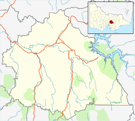
Molesworth is a town in the upper Goulburn Valley region of Victoria, Australia. The town is in the Shire of Murrindindi and on the Goulburn Valley Highway,[2] 125 kilometres (78 mi) northeast of the state capital, Melbourne.
Molesworth Post Office was opened on 1 January 1875 and was closed on 30 June 1994.[3] The railway arrived in 1890 and the station was closed in 1978.
Facilities in the town include a caravan park/campground, general store and public hall.
References
- ^ Australian Bureau of Statistics (28 June 2022). "Molesworth (Suburbs and Localities)". 2021 Census QuickStats. Retrieved 4 July 2022.
- ^ Google Maps, search "Molesworth, Victoria"
- ^ Premier Postal History, Post Office List, retrieved 22 August 2011

