Mount Pleasant, Western Australia
| Mount Pleasant Perth, Western Australia | |||||||||||||||
|---|---|---|---|---|---|---|---|---|---|---|---|---|---|---|---|
 Blue Gum Lake, Mount Pleasant | |||||||||||||||
| Coordinates | 32°01′42″S 115°50′56″E / 32.028214°S 115.8489476°E | ||||||||||||||
| Population | 7,456 (SAL 2021)[1] | ||||||||||||||
| Established | 1911 | ||||||||||||||
| Postcode(s) | 6153 | ||||||||||||||
| LGA(s) | City of Melville | ||||||||||||||
| State electorate(s) | Bateman and Riverton[2] | ||||||||||||||
| Federal division(s) | Tangney | ||||||||||||||
| |||||||||||||||
Mount Pleasant is a suburb of Perth, Western Australia, located within Wajuk country, and the City of Melville, on the Canning River. It is bounded by Canning Highway to the north, the Canning River to the east, Cranford Avenue, Moolyeen Road and Canning Avenue to the south, and Rogerson Road, Coomoora Road, Henley Road and Ardross Street to the west.[3]
Mount Pleasant Primary School is located entirely within the boundaries of Mount Pleasant, and Brentwood Primary School abuts Mount Pleasant in the south west of Mount Pleasant just south of Blue Gum Park.
Photos of the suburb
-
 Canning Bridge and Perth CBD as viewed from Mount Pleasant
 -
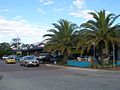 Queens Road shopping precinct
 -
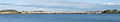 Mount Henry Bridge, taken from Deep Water Point

References
- ^ Australian Bureau of Statistics (28 June 2022). "Mount Pleasant (WA) (suburb and locality)". Australian Census 2021 QuickStats. Retrieved 28 June 2022.
- ^ "2015 Final Boundaries by Region and District (South Metropolitan Region)" (PDF). The Electoral Distribution Commissioners. Retrieved 3 May 2016.
- ^ Australian Bureau of Statistics (25 October 2007). "Mount Pleasant (State Suburb)". 2006 Census QuickStats. Retrieved 3 May 2016.
External links
![]() Media related to Mount Pleasant, Western Australia at Wikimedia Commons
Media related to Mount Pleasant, Western Australia at Wikimedia Commons