Nong Mamong district
Nong Mamong
หนองมะโมง | |
|---|---|
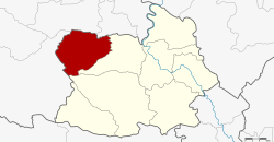 District location in Chai Nat province | |
| Coordinates: 15°16′36″N 99°52′0″E / 15.27667°N 99.86667°E | |
| Country | Thailand |
| Province | Chai Nat |
| Seat | Nong Mamong |
| District established | 1996 |
| Area | |
| • Total | 291.0 km2 (112.4 sq mi) |
| Population (2008) | |
| • Total | 19,330 |
| • Density | 67.1/km2 (174/sq mi) |
| Time zone | UTC+7 (ICT) |
| Postal code | 17100 |
| Geocode | 1807 |
Nong Mamong (Thai: หนองมะโมง) is the northwesternmost district (amphoe) of Chai Nat province, central Thailand.
Geography
Neighboring districts are (from the east clockwise) Wat Sing and Hankha of Chainat Province, Ban Rai, Huai Khot, Nong Chang and Nong Khayang of Uthai Thani province.
History
The minor district (king amphoe) was established on 15 July 1996 with four tambons split off from Wat Sing district.[1]
On 15 May 2007, all 81 minor districts were upgraded to full districts.[2] With publication in the Royal Gazette on 24 August the upgrade became official.[3]
Administration
The district is divided into four sub-districts (tambons), which are further subdivided into 42 villages (mubans). There are no municipal (thesaban) areas, and a further four tambon administrative organizations (TAO).
| No. | Name | Thai | Pop.[4] | |
|---|---|---|---|---|
| 1. | Nong Mamong | หนองมะโมง | 12 | 5,179 |
| 2. | Wang Takhian | วังตะเคียน | 14 | 6,596 |
| 3. | Saphan Hin | สะพานหิน | 10 | 5,130 |
| 4. | Kut Chok | กุดจอก | 6 | 2,425 |
References
- ^ ประกาศกระทรวงมหาดไทย เรื่อง แบ่งเขตท้องที่อำเภออำเภอวัดสิงห์ จังหวัดชัยนาท ตั้งเป็นกิ่งอำเภอหนองมะโมง (PDF). Royal Gazette (in Thai). 113 (Special 18 ง): 25. June 26, 1996. Archived from the original (PDF) on January 26, 2009.
- ^ แถลงผลการประชุม ครม. ประจำวันที่ 15 พ.ค. 2550 (in Thai). Manager Online.
- ^ พระราชกฤษฎีกาตั้งอำเภอฆ้องชัย...และอำเภอเหล่าเสือโก้ก พ.ศ. ๒๕๕๐ (PDF). Royal Gazette (in Thai). 124 (46 ก): 14–21. August 24, 2007. Archived from the original (PDF) on September 30, 2007.
- ^ "Population statistics 2008". Department of Provincial Administration. Archived from the original on 2012-08-19.