Paletwa Township
Paletwa Township
ပလက်ဝမြို့နယ် | |
|---|---|
 Location in Matupi district (in red) | |
| Country | |
| State | Rakine State |
| District | Matupi District |
| Area | |
| • Township | 3,127.04 sq mi (8,099.0 km2) |
| Elevation | 179 ft (55 m) |
| Population | |
| • Township | 64,971 |
| • Density | 21/sq mi (8.0/km2) |
| • Urban | 6,374 |
| • Rural | 58,597 |
| Time zone | UTC+6:30 (MST) |
Paletwa Township (Burmese: ပလက်ဝမြို့နယ်) is a township of Matupi District in the Chin State of Myanmar. It consists of Paletwa and Sami towns and Paletwa is the administrative center for the township. Also known as Arakan Hill Tract part of Arakan Division of British Burma.
Geography
Paletwa Township is located in southernmost part of Chin State. Its area is 3,127.04 sq mi (8,099.0 km2).[2]
Borders
Paletwa Township borders on:[3]
- Kanpetlet Township and Mindat Township to the east;
- Matupi Township to the northeast;
- Kyauktaw Township, Minbya Township and Mrauk-U Township of Rakhine State to the south;
- Buthidaung Township of Rakhine State, and Bangladesh to the west; and
- India to the north.
References
- ^ Census Report. The 2014 Myanmar Population and Housing Census. Vol. 2. Naypyidaw: Ministry of Immigration and Population. May 2015. p. 52.
- ^ "Paletwa Township Profile" Myanmar Information Management Unit (MIMU), May 2017 (in Burmese)
- ^ "Chin State's District Map" (PDF). Myanmar Information Management Unit. 23 October 2017. Retrieved 8 April 2018.
Capital: Hakha | ||
| Falam District | 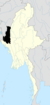 | |
| Hakha District | ||
| Matupi District | ||
| Mindat District | ||
| Cities and towns | ||
21°18′N 92°51′E / 21.300°N 92.850°E