Palkovice
Palkovice | |
|---|---|
 The village of Palkovice and Olešná Reservoir | |
 Flag  Coat of arms | |
 Palkovice Location in the Czech Republic | |
| Coordinates: 49°38′5″N 18°18′54″E / 49.63472°N 18.31500°E | |
| Country | |
| Region | Moravian-Silesian |
| District | Frýdek-Místek |
| First mentioned | 1437 |
| Government | |
| • Mayor | Radim Bača |
| Area | |
| • Total | 21.73 km2 (8.39 sq mi) |
| Elevation | 325 m (1,066 ft) |
| Population (2023-01-01)[1] | |
| • Total | 3,486 |
| • Density | 160/km2 (420/sq mi) |
| Time zone | UTC+1 (CET) |
| • Summer (DST) | UTC+2 (CEST) |
| Postal code | 739 41 |
| Website | www |
Palkovice is a municipality and village in Frýdek-Místek District in the Moravian-Silesian Region of the Czech Republic. It has about 3,500 inhabitants.
Administrative parts
The village of Myslík is an administrative part of Palkovice.
History
The first written mention of Palkovice is from 1437.[2]
Sights
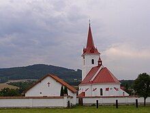
The landmark of Palkovice is the Church of Saint John the Baptist, built in 1631.[3]
References
- ^ "Population of Municipalities – 1 January 2023". Czech Statistical Office. 2023-05-23.
- ^ "Historie" (in Czech). Obec Palkovice. Retrieved 2022-01-21.
- ^ "Památky" (in Czech). Obec Palkovice. Retrieved 2022-01-21.
External links
Wikimedia Commons has media related to Palkovice.
| Authority control databases: National |
|---|