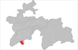
Panj District
Panj District
| |
|---|---|
 Location of the district in Tajikistan | |
| Coordinates: 37°14′N 69°09′E / 37.233°N 69.150°E | |
| Country | |
| Region | Khatlon Region |
| Capital | Panj |
| Area | |
• Total | 900 km2 (300 sq mi) |
| Population (2020) | |
• Total | 119,700 |
| • Density | 130/km2 (340/sq mi) |
| Time zone | UTC+5 |
| Official languages | |
| Website | panj |
Panj District (Russian: Пянджский район; Tajik: Ноҳияи Панҷ Nohiyai Panj) is a district in Khatlon Region, Tajikistan. Its capital is Panj. The population of the district is 119,700 (January 2020 estimate).[2] The district has been an area of ethnic tensions betweek its Uzbek and Tajik residents.[3] During the early Soviet period the district was officially named Kirovobod District.
Administrative divisions
The district has an area of about 900 km2 (300 sq mi) and is divided administratively into one town and five jamoats.[4] They are as follows:[5]
| Jamoat | Population (Jan. 2015)[5] |
|---|---|
| Panj (town) | 11,700[6] |
| Kabut Sayfutdinov | 22,684 |
| Mehvar | 17,298 |
| Namuna | 21,321 |
| Nuri Vahdat | 13,425 |
| Ozodagon | 20,748 |
References
- ^ "КОНСТИТУЦИЯ РЕСПУБЛИКИ ТАДЖИКИСТАН". prokuratura.tj. Parliament of Tajikistan. Retrieved 9 January 2020.
- ^ "Population of the Republic of Tajikistan as of 1 January 2020" (PDF) (in Russian). Statistics office of Tajikistan. Retrieved 9 October 2020.
- ^ Security and Human Right to Water in Central Asia, by Miguel Ángel Pérez Martín
- ^ "Regions of the Republic of Tajikistan 2017" (PDF) (in Russian). Statistics office of Tajikistan. pp. 15–21. Retrieved 12 October 2020.
- ^ a b Jamoat-level basic indicators, United Nations Development Programme in Tajikistan, accessed 9 October 2020
- ^ "Population of the Republic of Tajikistan as of 1 January 2015" (PDF) (in Russian). Statistics office of Tajikistan. Archived from the original (PDF) on 2 July 2015.
