The Blue Marble, a photograph of the planet Earth made on 7 December 1972 by the crew of the Apollo 17 spacecraft.
The world is the totality of entities, the whole of reality, or everything that is. The nature of the world has been conceptualized differently in different fields. Some conceptions see the world as unique while others talk of a "plurality of worlds". Some treat the world as one simple object while others analyze the world as a complex made up of parts. In scientific cosmology, the world or universe is commonly defined as "[t]he totality of all space and time; all that is, has been, and will be". Theories of modality talk of possible worlds as complete and consistent ways how things could have been. Phenomenology, starting from the horizon of co-given objects present in the periphery of every experience, defines the world as the biggest horizon or the "horizon of all horizons". In philosophy of mind, the world is contrasted with the mind as that which is represented by the mind. Theology conceptualizes the world in relation to God, for example, as God's creation, as identical to God or as the two being interdependent. In religions, there is a tendency to downgrade the material or sensory world in favor of a spiritual world to be sought through religious practice. A comprehensive representation of the world and our place in it, as is found in religions, is known as a worldview. Cosmogony is the field that studies the origin or creation of the world while eschatology refers to the science or doctrine of the last things or of the end of the world.
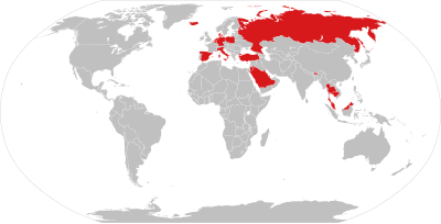
A map of nations which have Lèse-majesté laws as of September 2022 Freedom of speech is the concept of the inherent human right to voice one's opinion publicly without fear of government censorship or punishment. "Speech" is not limited to public speaking and is generally taken to include other forms of expression. The right is preserved in the United NationsUniversal Declaration of Human Rights and is granted formal recognition by the laws of most nations. Nonetheless, the degree to which the right is upheld in practice varies greatly from one nation to another. In many nations, particularly those with authoritarian forms of government, overt government censorship is enforced. Censorship has also been claimed to occur in other forms and there are different approaches to issues such as hate speech, obscenity, and defamation laws.
The following list is partially composed of the respective countries' government claims and does not fully reflect the de facto situation, however many sections of the page do contain information about the validity of the government's claims alongside said claims. (Full article...)
The retreat of glaciers since 1850 is well documented and is one of the effects of climate change. The retreat of mountain glaciers, notably in western North America, Asia, the Alps and tropical and subtropical regions of South America, Africa and Indonesia, provide evidence for the rise in global temperatures since the late 19th century. The acceleration of the rate of retreat since 1995 of key outlet glaciers of the Greenland and West Antarcticice sheets may foreshadow a rise in sea level, which would affect coastal regions. Excluding peripheral glaciers of ice sheets, the total cumulated global glacial losses over the 26-year period from 1993 to 2018 were likely 5500 gigatons, or 210 gigatons per yr.
Deglaciation occurs naturally at the end of ice ages, but glaciologists find the current glacier retreat is accelerated by the measured increase of atmospheric greenhouse gases and is thus effect of climate change. Glacier mass balance is the key determinant of the health of a glacier. If the amount of frozen precipitation in the accumulation zone exceeds the quantity of glacial ice lost due to melting or in the ablation zone a glacier will advance; if the accumulation is less than the ablation, the glacier will retreat. Glaciers in retreat will have negative mass balances, and if they do not find an equilibrium between accumulation and ablation, will eventually disappear. (Full article...)
Image 4
Global average temperatures show that the Medieval Warm Period was not a planet-wide phenomenon, and that the Little Ice Age was not a distinct planet-wide time period but rather the end of a long temperature decline that preceded recent global warming. The temperature record of the last 2,000 years is reconstructed using data from climate proxy records in conjunction with the modern instrumental temperature record which only covers the last 170 years at a global scale. Large-scale reconstructions covering part or all of the 1st millennium and 2nd millennium have shown that recent temperatures are exceptional: the Intergovernmental Panel on Climate ChangeFourth Assessment Report of 2007 concluded that "Average Northern Hemisphere temperatures during the second half of the 20th century were very likely higher than during any other 50-year period in the last 500 years and likely the highest in at least the past 1,300 years." The curve shown in graphs of these reconstructions is widely known as the hockey stick graph because of the sharp increase in temperatures during the last century. this broad pattern was supported by more than two dozen reconstructions, using various statistical methods and combinations of proxy records, with variations in how flat the pre-20th-century "shaft" appears. Sparseness of proxy records results in considerable uncertainty for earlier periods.
Individual proxy records, such as tree ring widths and densities used in dendroclimatology, are calibrated against the instrumental record for the period of overlap. Networks of such records are used to reconstruct past temperatures for regions: tree ring proxies have been used to reconstruct Northern Hemisphere extratropical temperatures (within the tropics trees do not form rings) but are confined to land areas and are scarce in the Southern Hemisphere which is largely ocean. Wider coverage is provided by multiproxy reconstructions, incorporating proxies such as lake sediments, ice cores and corals which are found in different regions, and using statistical methods to relate these sparser proxies to the greater numbers of tree ring records. The "Composite Plus Scaling" (CPS) method is widely used for large-scale multiproxy reconstructions of hemispheric or global average temperatures; this is complemented by Climate Field Reconstruction (CFR) methods which show how climate patterns have developed over large spatial areas, making the reconstruction useful for investigating natural variability and long-term oscillations as well as for comparisons with patterns produced by climate models. (Full article...)
Image 5
Medical professionals treating a COVID-19 patient in critical condition in an intensive care unit in São Paulo in May 2020
The Webb Ellis Cup, awarded to the winner of men's Rugby World Cup.
The Rugby World Cup is a men's rugby union tournament contested every four years between the top international teams, the winners of which are recognised as the World champions of the sport.
The tournament is administered by World Rugby, the sport's international governing body. The winners are awarded the Webb Ellis Cup, named after William Webb Ellis who, according to a popular legend, invented rugby by picking up the ball during a football game and running with it. (Full article...)
Image 7
Time zones of the world
A time zone is an area which observes a uniform standard time for legal, commercial and social purposes. Time zones tend to follow the boundaries between countries and their subdivisions instead of strictly following longitude, because it is convenient for areas in frequent communication to keep the same time.
Time zones are defined as one or two offsets from Coordinated Universal Time (UTC), and (if two offsets are used) the days when the offset changes. Some time zones switch between offsets throughout the year due to daylight saving time (DST). The UTC offsets range from UTC−12:00 to UTC+14:00, and are usually a whole number of hours, but a few zones are offset by an additional 30 or 45 minutes (such as in India, South Australia and Nepal). (Full article...)
Image 2A view of Earth with its global ocean and cloud cover, which dominate Earth's surface and hydrosphere; at Earth's polar regions, its hydrosphere forms larger areas of ice cover. (from Earth)
Image 3Pangaea was a supercontinent that existed from about 300 to 180 Ma. The outlines of the modern continents and other landmasses are indicated on this map. (from History of Earth)
Image 4Artist's conception of Hadean Eon Earth, when it was much hotter and inhospitable to all forms of life. (from History of Earth)
Image 9Artist's impression of Earth during the later Archean, the largely cooled planetary crust and water-rich barren surface, marked by volcanoes and continents, features already roundmicrobialites. The Moon, still orbiting Earth much closer than today and still dominating Earth's sky, produced strong tides. (from History of Earth)
Image 12Exaggerated illustration of Earth's elliptical orbit around the Sun, marking that the orbital extreme points (apoapsis and periapsis) are not the same as the four seasonal extreme points, the equinox and solstice (from Earth)
Image 17Change in average surface air temperature and drivers for that change. Human activity has caused increased temperatures, with natural forces adding some variability. (from Earth)
Image 27Earth's axial tilt causing different angles of seasonal illumination at different orbital positions around the Sun (from Earth)
Image 28Map of peopling of the world (Southern Dispersal paradigm), in thousands of years ago.
Image 29Geologic map of North America, color-coded by age. From most recent to oldest, age is indicated by yellow, green, blue, and red. The reds and pinks indicate rock from the Archean.
Image 30The Pantheon, originally a Roman temple, now a Catholic church
Image 31An animation of the changing density of productive vegetation on land (low in brown; heavy in dark green) and phytoplankton at the ocean surface (low in purple; high in yellow) (from Earth)
Image 33An artist's impression of the Archean, the eon after Earth's formation, featuring round stromatolites, which are early oxygen-producing forms of life from billions of years ago. After the Late Heavy Bombardment, Earth's crust had cooled, its water-rich barren surface is marked by continents and volcanoes, with the Moon still orbiting Earth half as far as it is today, appearing 2.8 times larger and producing strong tides. (from Earth)
Image 35The replicator in virtually all known life is deoxyribonucleic acid. DNA is far more complex than the original replicator and its replication systems are highly elaborate. (from History of Earth)
Image 50A 2012 artistic impression of the early Solar System's protoplanetary disk from which Earth and other Solar System bodies were formed (from Earth)
Image 51A schematic view of Earth's magnetosphere with solar wind flowing from left to right (from Earth)
Image 58Trilobites first appeared during the Cambrian period and were among the most widespread and diverse groups of Paleozoic organisms. (from History of Earth)
Image 59Empires of the world in 1898
Image 60Earth's western hemisphere showing topography relative to Earth's center instead of to mean sea level, as in common topographic maps (from Earth)
Image 61Earth's land use for human agriculture (from Earth)
Image 62Artist's rendition of an oxinated fully-frozen Snowball Earth with no remaining liquid surface water. (from History of Earth)
Image 74A reconstruction of human history based on fossil data. (from History of Earth)
Image 75A map of heat flow from Earth's interior to the surface of Earth's crust, mostly along the oceanic ridges (from Earth)
Image 76Earth's atmosphere as it appears from space, as bands of different colours at the horizon. From the bottom, afterglow illuminates the troposphere in orange with silhouettes of clouds, and the stratosphere in white and blue. Next the mesosphere (pink area) extends to just below the edge of space at one hundred kilometers and the pink line of airglow of the lower thermosphere (invisible), which hosts green and red aurorae over several hundred kilometers. (from Earth)
Image 77A reconstruction of Pannotia (550 Ma). (from History of Earth)
Image 81Tiktaalik, a fish with limb-like fins and a predecessor of tetrapods. Reconstruction from fossils about 375 million years old. (from History of Earth)
Image 82Conjectured illustration of the scorched Earth after the Sun has entered the red giant phase, about 5–7 billion years from now (from Earth)
Image 87Artist's impression of a Hadean landscape with the relatively newly formed Moon still looming closely over Earth and both bodies sustaining strong volcanism. (from History of Earth)
Image 88Artist's impression of the enormous collision that probably formed the Moon (from History of Earth)
The Seven Wonders of Portugal (Portuguese: Sete Maravilhas de Portugal) is a list of cultural wonders located in Portugal. The creation of the list was supported by the Ministry of Culture and organized by the companies Y&R Brands S.A. and Realizar S.A.
Protected areas of Canada consist of approximately 12.1 percent of the nation's landmass and freshwater are considered conservation areas, including 11.4 percent designated as protected areas. Approximately 13.8 percent of Canada's territorial waters are conserved, including 8.9 percent designated as protected areas. Terrestrial areas conserved have increased by 65 percent in the 21st century, while marine areas conserved have increased by more than 3,800 percent.
Conservation and protected areas have different mandates depending on the organization which manages them, with some areas having a greater focus on ecological integrity, historical preservation, public usage, scientific research, or a combination of usages. Some areas such as the Polar Bear Pass, are co-managed and overseen by government and local indigenous agencies. (Full article...)
There are four categories of protected areas in India, constituted under the Wildlife Protection Act, 1972. Tiger reserves consist of areas under national parks and wildlife sanctuaries. There are 53 tiger reserves in India. the protected areas of India cover 173,629.52 square kilometres (67,038.73 sq mi), roughly 5.28% of the total geographical area of the country. (Full article...)
The headquarters of the National Parks Service are in downtown Buenos Aires, on Santa Fe Avenue. A library and information centre are open to the public. The administration also covers the national monuments, such as the Jaramillo Petrified Forest, and natural and educational reserves. (Full article...)
Meanwhile, the central government has proclaimed the Coastline and the Tirana Greenbelt as areas of national importance. (Full article...)
Image 9
Redwood grove in Redwood National Park According to the California Protected Areas Database (CPAD), in the state of California, United States, there are over 14,000 inventoried protected areas administered by public agencies and non-profits. In addition, there are private conservation areas and other easements. They include almost one-third of California's scenic coastline, including coastal wetlands, estuaries, beaches, and dune systems. The California State Parks system alone has 270 units and covers 1.3 million acres (5,300 km2), with over 280 miles (450 km) of coastline, 625 miles (1,006 km) of lake and river frontage, nearly 18,000 campsites, and 3,000 miles (5,000 km) of hiking, biking, and equestrian trails.
Obtaining an accurate total of all protected land in California and elsewhere is a complex task. Many parcels have inholdings, private lands within the protected areas, which may or may not be accounted for when calculating total area. Also, occasionally one parcel of land is included in two or more inventories. Over 90% of Yosemite National Park for example, is listed both as wilderness by the National Wilderness Preservation System, and as national park land by the National Park Service. The Cosumnes River Preserve is an extreme example, owned and managed by a handful of public agencies and private landowners, including the Bureau of Land Management, the County of Sacramento and The Nature Conservancy. Despite the difficulties, the CPAD gives the total area of protected land at 49,294,000 acres (199,490 km2), or 47.05% of the state (not including easements); a considerable amount for the most populous state in the country. (Full article...)
Image 10
Forests in the state of Himachal Pradesh (northern India) currently cover an area of nearly 37,939 square kilometres (14,648 sq mi), which is about 68.16% of the total land area of the state. The forests were once considered to be the main source of income of the state and most of the original forests were clear felled. The emphasis has shifted, however, from exploitation to conservation. The state government aims to increase forest cover to 50% of the total land area. There have been various projects, including the establishment of protected areas such as National Parks, designed to preserve and expand the forests. (Full article...)
National parks of Victoria State parks of Victoria Marine national parks of Victoria Marine and coastal parks of Victoria Marine sanctuaries of Victoria Other parks of Victoria
West Matukituki Valley and the Matukituki River seen from Cascade Saddle in Mount Aspiring National Park Protected areas of New Zealand are areas that are in some way protected to preserve their environmental, scientific, scenic, historical, cultural or recreational value. There are about 10,000 protected areas, covering about a third of the country. The method and aims of protection vary according to the importance of the resource and whether it is publicly or privately owned.
Image 3Only a few of the largest large igneous provinces appear (coloured dark purple) on this geological map, which depicts crustal geologic provinces as seen in seismic refraction data
Image 4A plate tectonics map with volcano locations indicated with red circles


 A view of Earth with its global ocean and cloud cover, which dominate Earth's surface and hydrosphere; at Earth's polar regions, its hydrosphere forms larger areas of ice cover. (from Earth)
 Pangaea was a supercontinent that existed from about 300 to 180 Ma. The outlines of the modern continents and other landmasses are indicated on this map. (from History of Earth)
 Artist's conception of Hadean Eon Earth, when it was much hotter and inhospitable to all forms of life. (from History of Earth)

 Artist's conception of Devonian flora (from History of Earth)
 Artist's impression of Earth during the later Archean, the largely cooled planetary crust and water-rich barren surface, marked by volcanoes and continents, features already round microbialites. The Moon, still orbiting Earth much closer than today and still dominating Earth's sky, produced strong tides. (from History of Earth)
 A composite image of artificial light emissions at night on a map of Earth (from Earth)


 Image of the physical world, captured by the Hubble Space Telescope (from World)
 Last Moon landing: Apollo 17 (1972)
 Change in average surface air temperature and drivers for that change. Human activity has caused increased temperatures, with natural forces adding some variability. (from Earth)
 Ming dynasty section, Great Wall of China

 Taj Mahal, Mughal Empire, India
 Chloroplasts in the cells of a moss (from History of Earth)
 Olmec colossal head, now at the Museo de Antropología de Xalapa
 An artist's rendering of a protoplanetary disk (from History of Earth)
 A computer-generated image mapping the prevalence of artificial satellites and space debris around Earth in geosynchronous and low Earth orbit (from Earth)
 Earth's axial tilt causing different angles of seasonal illumination at different orbital positions around the Sun (from Earth)
 Map of peopling of the world (Southern Dispersal paradigm), in thousands of years ago.
 Geologic map of North America, color-coded by age. From most recent to oldest, age is indicated by yellow, green, blue, and red. The reds and pinks indicate rock from the Archean.
 The Pantheon, originally a Roman temple, now a Catholic church
 An animation of the changing density of productive vegetation on land (low in brown; heavy in dark green) and phytoplankton at the ocean surface (low in purple; high in yellow) (from Earth)
 Great Mosque of Kairouan, Tunisia, founded 670 CE
 Persepolis, Achaemenid Empire, 6th century BCE
 The replicator in virtually all known life is deoxyribonucleic acid. DNA is far more complex than the original replicator and its replication systems are highly elaborate. (from History of Earth)
 A view of Earth with different layers of its atmosphere visible: the troposphere with its clouds casting shadows, a band of stratospheric blue sky at the horizon, and a line of green airglow of the lower thermosphere around an altitude of 100 km, at the edge of space (from Earth)
 Standing Buddha from Gandhara, 2nd century CE

 World population, 10,000 BCE to 2023 CE, with projection to 2100 CE (from Human history)
 Shanghai. China urbanized rapidly in the 21st century.


 The pale orange dot, an artist's impression of the early Earth which might have appeared orange through its hazy methane rich prebiotic second atmosphere. Earth's atmosphere at this stage was somewhat comparable to today's atmosphere of Titan. (from History of Earth)
 View of Earth from the Moon by the Lunar Reconnaissance Orbiter (from Earth)
 Tracy Caldwell Dyson, a NASA astronaut, observing Earth from the Cupola module at the International Space Station on 11 September 2010 (from Earth)
 A 2012 artistic impression of the early Solar System's protoplanetary disk from which Earth and other Solar System bodies were formed (from Earth)
 A schematic view of Earth's magnetosphere with solar wind flowing from left to right (from Earth)
 First airplane, the Wright Flyer, flew on 17 December 1903.
 A composite image of Earth, with its different types of surface discernible: Earth's surface dominating Ocean (blue), Africa with lush (green) to dry (brown) land and Earth's polar ice in the form of Antarctic sea ice (grey) covering the Antarctic or Southern Ocean and the Antarctic ice sheet (white) covering Antarctica. (from Earth)
 A banded iron formation from the 3.15 Ga Moodies Group, Barberton Greenstone Belt, South Africa. Red layers represent the times when oxygen was available; gray layers were formed in anoxic circumstances. (from History of Earth)
 Cross-section through a liposome (from History of Earth)
 Satellite time lapse imagery of Earth's rotation showing axis tilt (from Earth)
 Trilobites first appeared during the Cambrian period and were among the most widespread and diverse groups of Paleozoic organisms. (from History of Earth)
 Empires of the world in 1898
 Earth's western hemisphere showing topography relative to Earth's center instead of to mean sea level, as in common topographic maps (from Earth)
 Earth's land use for human agriculture (from Earth)
 Artist's rendition of an oxinated fully-frozen Snowball Earth with no remaining liquid surface water. (from History of Earth)
 Battle during 1281 Mongol invasion of Japan
 Lithified stromatolites on the shores of Lake Thetis, Western Australia. Archean stromatolites are the first direct fossil traces of life on Earth. (from History of Earth)
 Japanese depiction of a Portuguese carrack. European maritime innovations led to proto-globalization.
 "Lucy", the first Australopithecus afarensis skeleton found. Lucy was only 1.06 m (3 ft 6 in) tall.
 Florence, birthplace of the Italian Renaissance
 Graph showing range of estimated partial pressure of atmospheric oxygen through geologic time (from History of Earth)
 A pillar at Göbekli Tepe
 Earth's history with time-spans of the eons to scale (from History of Earth)
 Ajloun Castle, Jordan
 Vitruvian Man by Leonardo da Vinci epitomizes the advances in art and science seen during the Renaissance. (from History of Earth)
 A reconstruction of human history based on fossil data. (from History of Earth)
 A map of heat flow from Earth's interior to the surface of Earth's crust, mostly along the oceanic ridges (from Earth)
 Earth's atmosphere as it appears from space, as bands of different colours at the horizon. From the bottom, afterglow illuminates the troposphere in orange with silhouettes of clouds, and the stratosphere in white and blue. Next the mesosphere (pink area) extends to just below the edge of space at one hundred kilometers and the pink line of airglow of the lower thermosphere (invisible), which hosts green and red aurorae over several hundred kilometers. (from Earth)
 A reconstruction of Pannotia (550 Ma). (from History of Earth)
 An artist's impression of ice age Earth at glacial maximum. (from History of Earth)
 A 580 million year old fossil of Spriggina floundensi, an animal from the Ediacaran period. Such life forms could have been ancestors to the many new forms that originated in the Cambrian Explosion. (from History of Earth)
 Tiktaalik, a fish with limb-like fins and a predecessor of tetrapods. Reconstruction from fossils about 375 million years old. (from History of Earth)
 Dinosaurs were the dominant terrestrial vertebrates throughout most of the Mesozoic (from History of Earth)
 Fall of the Berlin Wall, 1989
 Angkor Wat temple complex, Cambodia, early 12th century
 Artist's impression of a Hadean landscape with the relatively newly formed Moon still looming closely over Earth and both bodies sustaining strong volcanism. (from History of Earth)
 Artist's impression of the enormous collision that probably formed the Moon (from History of Earth)
 Yggdrasil, an attempt to reconstruct the Norse world tree which connects the heavens, the world, and the underworld. (from World)
 Chennakesava Temple, Belur, India
 A Benin Bronze head from Nigeria


 National parks of Victoria
  State parks of Victoria
  Marine national parks of Victoria
  Marine and coastal parks of Victoria
  Marine sanctuaries of Victoria
  Other parks of Victoria


 Time zones of the world
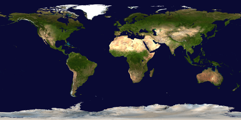
 Mollweide projection of the world
 Only a few of the largest large igneous provinces appear (coloured dark purple) on this geological map, which depicts crustal geologic provinces as seen in seismic refraction data
 A plate tectonics map with volcano locations indicated with red circles
 Index map from the International Map of the World (1:1,000,000 scale)
 1516 map of the world by Martin Waldseemüller
 The world map by Gerardus Mercator (1569), the first map in the well-known Mercator projection
 The Goode homolosine projection is a pseudocylindrical, equal-area, composite map projection used for world maps.
 United Nations Human Development Index map by country (2016)


 Commons
 Wikibooks
 Wikidata
 Wikinews
 Wikiquote
 Wikisource
 Wikispecies
 Wikiversity
 Wikivoyage
 Wiktionary


