San José del Monte
San Jose del Monte | |
|---|---|
| City of San Jose del Monte | |
   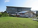   (From top, left to right : Our Lady of Lourdes Grotto Shrine • St. Joseph the Worker Church • SM City San Jose del Monte View Deck • New City Hall and River Esplanade • Mount Balagbag • People's Park & Sports Complex) | |
 Flag  Seal | |
| Nickname(s): The Rising City, Balcony of the Metropolis, The First City of Bulacan | |
| Motto: Arya San Joseño! | |
| Anthem: San Jose del Monte Hymn | |
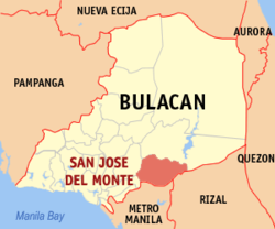 Map of Bulacan with San Jose del Monte highlighted | |
 San Jose del Monte Location within the Philippines | |
| Coordinates: 14°48′50″N 121°02′43″E / 14.8139°N 121.0453°E | |
| Country | Philippines |
| Region | Central Luzon |
| Province | Bulacan |
| District | Lone district |
| Founded | March 2, 1752 |
| Cityhood | September 10, 2000 |
| Lone district | December 18, 2003 |
| Named for | Saint Joseph |
| Barangays | 59 (see Barangays) |
| Government | |
| • Type | Sangguniang Panlungsod |
| • Mayor | Arthur B. Robes |
| • Vice Mayor | Efren C. Bartolome Jr. |
| • Representative | Florida P. Robes |
| • City Council | Members |
| • Electorate | 261,740 voters (2022) |
| Area | |
| • Total | 105.53 km2 (40.75 sq mi) |
| Elevation | 122 m (400 ft) |
| Highest elevation | 1,179 m (3,868 ft) |
| Lowest elevation | −1 m (−3 ft) |
| Population (2020 census)[3] | |
| • Total | 651,813 |
| • Density | 6,200/km2 (16,000/sq mi) |
| • Households | 156,871 |
| Demonym | San Joseño |
| Economy | |
| • Income class | 1st city income class |
| • Poverty incidence | 4.64 |
| • Revenue | ₱ 2,183 million (2020) |
| • Assets | ₱ 4,120 million (2020) |
| • Expenditure | ₱ 1,957 million (2020) |
| • Liabilities | ₱ 1,054 million (2020) |
| Utilities | |
| • Electricity | Meralco |
| • Water | San Jose Del Monte City Water District |
| • Telecommunications | Globe Telecom Smart Communications Dito Telecommunity |
| Time zone | UTC+8 (PST) |
| ZIP code | 3023, 3024 |
| PSGC | |
| IDD : area code | +63 (0)44 |
| Native languages | Tagalog |
| Catholic diocese | Diocese of Malolos |
San Jose del Monte, officially the City of San Jose del Monte (abbreviated as SJDM or CSJDM; Filipino: Lungsod ng San Jose del Monte), is a 1st class component city in the province of Bulacan, Philippines. According to the 2020 census, it has a population of 651,813 people, making it the largest local government unit within the province of Bulacan and Central Luzon, and the 18th most populated city in the Philippines.
It was proclaimed as a component city on September 10, 2000 through Republic Act No. 8797. Its conversion into a highly urbanized city was by the virtue of Proclamation No. 1057 issued by President Rodrigo Duterte on December 4, 2020; the conversion was rejected on a plebiscite held on October 30, 2023, by the voters of Bulacan including the concerned city.[5]
Located in the southeast of the province, it is bordered by the city of Caloocan in Metro Manila to the south, by the town of Rodriguez in Rizal to the east, the towns of Santa Maria and Marilao to the west and Norzagaray to the north. San Jose del Monte is 65 kilometres (40 mi) from Malolos and 30 kilometres (19 mi) from Manila.
The city is home to some of the biggest resettlement areas in the Philippines like the Sapang Palay resettlement area spread over 36 barangays, Pabahay 2000 in Barangay Muzon and Towerville in Barangay Minuyan Proper. Most of the city's population come from former informal settlers along the creeks, esteros, riverbanks and railway tracks of Metro Manila.[6]
Etymology
San Jose Del Monte derived its name from Saint Joseph, whose statue was found in a veritable forest. The hunters called it as such, which literally means “Saint Joseph of the Mountain” in Spanish.
History
Early accounts on the founding of the city, as gathered from the old people, contend that it was formerly a part of the town of Meycauayan. This is supported by a decree from the Archbishop of Manila dated March 1750 on the creation of new municipalities. The municipality of San Jose del Monte was then officially founded on 2 March 1752.[7]
The decree included the list of families who volunteered to be relocated. These families, most if not all from Lagulo (now Malhacan) in Meycauayan, brought with them rice, wine, nganga and salt from in exchange for the wild pigs, deer, yantok and almasigan of the Itas and Dumagats, the native inhabitants of the area. Solares, including intended lots for main roads, were peacefully distributed to the new occupants after being measured and surveyed.[7]
In all probability, the hunters reported their find to the parish priest of Meycauayan. It was said that the priest built a stone church at the site where the town proper is now located. The statue was installed in the new church. Extant Catholic Church records reveal that the first parish priest was Father Antonio de Moral. He took charge of the parish in 1845.
During the revolt against Spain, the town became a battleground between the Katipuneros and the Spanish forces. The revolutionaries lost and the vengeful Spanish soldiers burned down the settlement. The town people fled for their lives to nearby towns. At the advent of the American rule, it was made a part of Santa Maria until 1918 when the town was recreated and Ciriaco Gallardo appointed the first municipal president. Public schools were opened at the start of the American regime but due to the scarcity of the population, the highest grade organized was at the fourth grade.

During the Japanese occupation, the town became an ideal hiding place of the local recognized guerrillas because of the town's hilly and wooden terrain. The Japanese Imperial Army took over the local government of San Jose del Monte from 1942 to 1943. In resistance, the municipality formed its own guerrilla unit. San Jose del Monte experienced large casualties when the Americans bombed the town center on 11 January 1945, and again on 14 January 1945. When the combined Filipino and American troops came, peace reigned but not for long.
At the height of the Hukbalahap Rebellion, the town was raided on 10 October 1950. The Huks burned down the town hall. The town was raided for the second time on 21 March 1951. The Huks did not succeed because of the precautionary measures instituted by the town officials after which the Huks were gradually eliminated.
In the 1980s, thousands of informal settlers from Metro Manila were relocated to San Jose del Monte. Due to the large amount of residents, Bulacan Governor Roberto Pagdanganan recalled in 1996 that the relocation did not ensure new livelihoods for its informal settlers, thus turning many squatters toward criminality; he noted that the town had the highest crime rate in the province according to police reports.[8]
In 1988, Eduardo Roquero was elected mayor of the municipality by a margin of eight (8) votes against his closest opponent, reelectionist Reynaldo Villano.[9]
Cityhood
2000 plebiscite and later events
In December 1999, district representative Angelito Sarmiento filed the bill converting the then municipality of San Jose del Monte into a component city. This was approved on July 15, 2000 as Republic Act No. 8797.[10][11]
| Choice | Votes | % |
|---|---|---|
| 20,331 | 62.30 | |
| No | 12,304 | 37.70 |
| Valid votes | 32,635 | 100.00 |
| Invalid or blank votes | 0 | 0.00 |
| Total votes | 32,635 | 100.00 |
| Registered voters/turnout | 120,380 | 27.11% |
| Source: [10] | ||
A plebiscite was held on September 10, 2000. Despite a low turnout, the cityhood was approved mostly by migrants, mainly from Metro Manila and which composed seventy percent of the residents by then; only nine of then 59 villages voted against the bill. Official proclamation was held in the evening. San Jose del Monte became the first city in Bulacan since Malolos failed in the cityhood bid in December 1999.[10] (Malolos was eventually declared a city in 2002 by the Commission on Elections which had reversed the official result following a recount.)[12] It was also recorded as the country's 86th chartered city.[7]
Through RA No. 9230, amending the city charter and approved on December 18, 2003, the city was granted its own legislative district, the province's first lone district,[7] while barangays were classified into two districts for purposes of representation in the Sangguniang Panlungsod. Officers were to be first elected in 2004.[13]
Highly urbanized city
On December 4, 2020, President Rodrigo Duterte declared San Jose del Monte as a highly urbanized city through Proclamation No. 1057.[14][15] However, it will have to go through a plebiscite to ratify its city charter. It was supposed to be held four months after the 2022 national and local elections[16] but it was overdue ever since then. Hence, the proclamation remained pending for its HUC status for a long time beyond the national and local elections. On September 11, 2023, COMELEC, released a resolution that synchronized the plebiscite on October 30, 2023, along with the barangay and Sangguniang Kabataan elections.[17][18]
Majority of voters rejected the conversion, as declared by the COMELEC two days after the plebiscite.[19] Meanwhile, a tenth of those who joined did not vote, leaving blank ballots.[20]
Geography
The elevation of the city ranges from approximately 40 to 900 meters (130 to 2,950 ft) above sea level; the relief transitions from warm lowland to cool upland as one goes eastward. This is because the city is part of the Sierra Madre mountain range. Plains and river valley flats characterize the western and southwestern quadrant. The central portion and much of its eastern section are made up of undulating hills with low relief. High relief areas moderate slopes best describe its extreme eastern and northwestern quadrant. Slopes of 3%-8% are extensively found in the city, particularly on the western half. Slopes of 30%-50% comprise the smallest portion of the total land area.
The rivers and creeks that flow in San Jose del Monte are direct tributaries of the Angat River, which flows from the Angat Reservoir. Major natural waterways of San Jose del Monte are the Kipungok, Santo Cristo, and Santa Maria River systems. Kipungok River separates San Jose del Monte from Caloocan and Rodriguez. It is directly connected to the Marilao River, which flows downwards to Manila Bay. Draining to these rivers are creeks and streams, which act as catchment areas for the surface water runoff of the city. Among these are the Bigte, Kantulot, Katinga, and Salamin creeks.[21]
General Land Use
Growing commercial, residential, and light industrial areas, are found all over the city at major road intersections and along major thoroughfares. However, the bulk of the San Jose del Monte's built-up areas are mostly west of Quirino Highway at the primary level to gently sloping 8% terrain, dividing the city into a heavily built-up western section and the largely agricultural eastern section. Most of the city's schools, government institutions, commercial developments, industries, and other urban amenities are in this section. The largest contiguous built-up area is at Sapang Palay Resettlement Project area, followed by the conurbation in Tungkong Mangga and Muzon.
The developments east of the Quirino Highway are mostly scattered residential areas and agricultural lands. However, there are a few subdivisions that are some distance away from Ciudad Real and take advantage of its secluded and rural atmosphere. These are the Blessed Sacrament Seminary and an Augustinian convent.
In between the built-up clusters are pockets of agricultural lands, which are continuously converted into built-up uses. Planted in these lands are crops such as rice and corn. The clustering pattern for both built-up and agricultural uses is partly due to the decisions made by settlers with regard to the hilly conditions that dominate the topography. Most of households in the western half of San Jose del Monte opted to convert their lands to residential uses while other maintained the farms. This left upland uses, such as those pertaining to forest use, more common towards the easternmost zones.
Most vegetative outgrowths are in areas that are difficult to build on. But there are instances when these outgrowths are integrated in the built-up areas, usually found in the west: a number of heavily vegetated areas. Supplementing these are mini forest projects of the city government. The City Agriculture Office maintains a 1.65-hectare (4.1-acre) Mini Forest Project in Barangay Muzon along the San Jose del Monte–Marilao Road and a mahogany planting site.[22]
Climate
| Climate data for San Jose del Monte City, Bulacan | |||||||||||||
|---|---|---|---|---|---|---|---|---|---|---|---|---|---|
| Month | Jan | Feb | Mar | Apr | May | Jun | Jul | Aug | Sep | Oct | Nov | Dec | Year |
| Mean daily maximum °C (°F) | 29 (84) |
30 (86) |
32 (90) |
34 (93) |
33 (91) |
31 (88) |
30 (86) |
29 (84) |
29 (84) |
30 (86) |
30 (86) |
29 (84) |
31 (87) |
| Mean daily minimum °C (°F) | 20 (68) |
20 (68) |
21 (70) |
23 (73) |
24 (75) |
25 (77) |
24 (75) |
24 (75) |
24 (75) |
23 (73) |
22 (72) |
21 (70) |
23 (73) |
| Average precipitation mm (inches) | 7 (0.3) |
7 (0.3) |
9 (0.4) |
21 (0.8) |
101 (4.0) |
152 (6.0) |
188 (7.4) |
170 (6.7) |
159 (6.3) |
115 (4.5) |
47 (1.9) |
29 (1.1) |
1,005 (39.7) |
| Average rainy days | 3.3 | 3.5 | 11.1 | 8.1 | 18.9 | 23.5 | 26.4 | 25.5 | 24.5 | 19.6 | 10.4 | 6.4 | 181.2 |
| Source: Meteoblue[23] | |||||||||||||
Barangays

(prior to the split of Barangay Muzon in 2023)
San Jose del Monte is politically subdivided into 62 barangays.[24] Each barangay consists of puroks and some have sitios.
It is originally made up of only six barangays: Poblacion, Halang (Muzon), Sapang Palay, Minuyan, Santo Cristo, and Gaya-Gaya. Over time, these six mother barangays were divided to provide better accommodation for the people, particularly in the Sapang Palay Ressetlement Area (Hacienda de Sapang Palay), which stretches all the way to Minuyan.
There is an ongoing land disputes with the municipality of Norzagaray, Bulacan regarding both territories. Such disputes can be located in upper portion of Assumption, eastern portion of Santo Niño II, eastern portion of San Martin de Porres, eastern portion of Lawang Pari, eastern portion of Minuyan Proper, Kaybanban, San Roque, Paradise III, San Isidro, upper portion of Tungkong Mangga, upper portion of Ciudad Real barangays in San Jose del Monte and lower portion of Tigbe, lower portion of Bitungol, lower portion of Minuyan, lower portion of Bigte, lower portion of San Mateo (Sitio Kaharume), mountainous portion of San Lorenzo barangays in Norzagaray.
Historical maps of Bulacan, before the creation of Doña Remedios Trinidad, indicates that both territories of San Jose del Monte and Norzagaray stretches all the way up to Tayabas province (now Quezon province).
These barangays are grouped into two districts, the first with a Postal/ZIP Code of 3023, and the second with 3024. Twenty-six (26) barangays comprise the first district while the 36 barangays located in Sapang Palay 36 compose the second district.
The city's administrative center is located in Poblacion 1, home to the city's major government and non-government services. Dulong Bayan, on the other hand, is set to become the city's new seat of government, with the new government center being erected there. San Jose del Monte has 4 major urban centers, called nodes: Muzon node (consisting the four barangays of Muzon), Poblacion node (consisting the two barangays of Poblacion), Sapang Palay node (consisting the barangays surrounding Sampol Market), and Tungkong Mangga node.
The most recently created barangays are Muzon Proper, Muzon East, Muzon West and Muzon South created from dividing Barangay Muzon.[25] The four barangays were made through the approval of a law on March 25, 2023 through a plebiscite.[26]
- ‡ City Administrative Center
- † Seat of the City Government
- ∗ Urban Center/Node
- Barangay
The population of the second district (Sapang Palay), if combined, would be 214,100, slightly lower than Meycauayan but higher than the City of Baliwag.
Demographics
| Year | Pop. | ±% p.a. |
|---|---|---|
| 1903 | 1,378 | — |
| 1918 | 3,141 | +5.65% |
| 1939 | 5,826 | +2.99% |
| 1948 | 5,363 | −0.92% |
| 1960 | 9,329 | +4.72% |
| 1970 | 18,704 | +7.19% |
| 1975 | 59,021 | +25.92% |
| 1980 | 90,732 | +8.98% |
| 1990 | 142,047 | +4.59% |
| 1995 | 201,394 | +6.76% |
| 2000 | 315,807 | +10.12% |
| 2007 | 439,090 | +4.65% |
| 2010 | 454,553 | +1.27% |
| 2015 | 574,089 | +4.55% |
| 2020 | 651,813 | +2.53% |
| Source: Philippine Statistics Authority[28][29][30][31] | ||
In the 2020 census, the population of San Jose del Monte was 651,813 people,[3] with a density of 6,200 inhabitants per square kilometer or 16,000 inhabitants per square mile. This makes it the largest local government unit in Bulacan province. It is also the largest city in Central Luzon (Region III).[32]
With the coming of settlers to San Jose del Monte, its population increased tremendously. Its population increased dramatically since the 1950s as the population tended to move from rural areas to towns and cities. Its proximity to Manila allowed it to accommodate its spillover population. This is further hastened by the development of nearby Quezon City and the accompanying increase in population and infrastructure.
Forced relocation of informal settlers and the lure of government to provide them their own homes allowed the town to continue to grow despite the lack of government facilities then. As such, San Jose del Monte exhibited an increasing percentage share to the provincial population from as low as 2% in 1960 to 9% in 1990 and then to 17% in 2015. The town surpassed the population of Meycauayan in 1980 census and Malolos in the 1990 census, then the largest towns of Bulacan. By 2015, it has more than two times the population of the now second place Santa Maria town (256,454 people in the 2015 Census).
If current population growth holds (2010-2015, +4.55%), the population of San Jose del Monte is expected to double and breach one million by the 2030 Census.
Economy
Agriculture

Major agricultural crops are leafy vegetables, root crops (cassava as its OTOP), pineapple, mango and coffee beans.
Livestock and poultry
The major income earner is large- and small-scale swine production. There are 60 commercial livestock and poultry farms in the city. The major poultry producers are RFM Corporation, Vitarich and FELDAN.
Trade and commerce

The city has three major business district growth areas: Tungkong Mangga, Muzon and Sapang Palay (Sampol). They are in wholesale and retail trade.
The minor business districts include Towerville in Minuyan Proper, Palmera in Kaypian, Northgate in Santo Cristo, Citrus, Poblacion 1, Grotto in Graceville, Francisco Homes, Gumaoc and San Rafael III.
Commercial and thrift banks, pawnshops and cooperatives provide financial services. There are two major malls: Starmall San Jose del Monte in Palmera and SM City San Jose del Monte in Tungkong Mangga.
Tourism
- Mount Balagbag and Kaytitinga Falls (Barangay San Isidro) are the main tourist attractions in the city. A portion of the Angat Watershed Forest Reserve also extends to San Jose del Monte.
- VS Orchids Farm (Santo Cristo) is the biggest orchids nursery and ornamental plants farm in Bulacan owned by Rolita Spowart, 3 Manila Seedling Bank Foundation, Quezon City.[40] Hundreds of orchids species are nurtured in this 1.8 hectares flora haven.
- The Our Lady of Lourdes Grotto Shrine (Graceville) is a Roman Catholic pilgrimage site often visited by devotees during Holy Week.
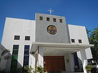
- Saint Joseph the Worker Parish Church (Poblacion 1) is the main historical pilgrimage site in the heart of the city.
- People's Park of San Jose del Monte (Sapang Palay Proper)
- River Park Esplanade (Dulong Bayan)
- The Rising Heart and Padre Pio Mountain of Healing (Paradise III)
- Grotto Vista Resort (Graceville)
- Los Arcos de Hermano Resort and Events (Tungkong Mangga)
-
 Mount Balagbag
 -
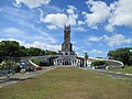 Grotto of Our Lady of Lourdes
 -
 Kaytitinga Falls
 -
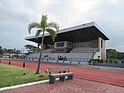
 San Jose del Monte People's Park & Sports Complex
 -
 San Jose del Monte City River Park Esplanade
 -
 Grotto Vista Resort


Infrastructure
Transportation

The city is serviced by bus routes going to and from Parañaque (PITX), Santa Cruz in Manila, Quezon City, and Ninoy Aquino International Airport. Jeepney, e-jeepney, and minibus routes also ply the roads between the city and neighboring cities and towns in Metro Manila and Bulacan.
Road Network
San Jose del Monte's road network has a total length of 211.43 kilometers (131.38 mi). The following are the main arteries of San Jose del Monte's road network which link the 59 barangays with Metro Manila and the rest of Bulacan.
- Quirino Highway is a national road which stretches from the town of Norzagaray (Bigte Rotonda) to Quezon City (Balintawak).
- Bocaue–San Jose Road, also called Gov. Fortunato Halili Avenue, is a provincial road which links the city passing through Tungkong Mangga (Tungko) via Muzon to the town of Santa Maria, Bocaue and to the North Luzon Expressway.
- Sapang Palay–Santa Maria Road links the Sapang Palay Resettlement Project to town of Santa Maria passing through Barangay Bulac, Barangay Catmon, and Barangay San Jose Patag in the said town.
- San Jose–Marilao Road, also referred to as Miguel Villarica Road, links the city with the municipality of Marilao and to the North Luzon Expressway. This is now a permanent full exit.
- Dr. Eduardo V. Roquero Avenue links the Sapang Palay Resettlement Project to Quirino Highway and in the opposite end to Sapang Palay Proper.
- Igay Provincial Road connects Quirino Highway to Rodriguez, Rizal, passing through Santo Cristo, Kaybanban, San Roque, Paradise III, and San Isidro barangays.
- Kaypian Road connects Barangay Dulong Bayan to Starmall-San Jose del Monte via Barangay Kaypian and links to Quirino Highway.
Railway Network
The city is also the site of the under-preparation terminus of Manila Metro Rail Transit (MRT) Line 7. The initial location of the said station, named San Jose del Monte Station, would be located near the area of Colinas Verdes, a subdivision in Tungkong Mangga, San Jose del Monte, passing through Tala, North Caloocan and barangay Ciudad Real.
However, due to the appeals the residents of Pangarap Village in Tala over years of land dispute and right-of-way issues, in 2021, the railway leading to the station was realigned, now passing through Quirino Highway instead of passing through the said disputed residential community, and the new site of San Jose del Monte station would now be located on a vast vacant lot alongside Skyline Hospital and Medical Center.[41][42]
Water

The bulk of the city's water requirement is being served by the San Jose Del Monte City Water District,[43] together via Joint Venture Agreement to Prime Water Corporation.
Power
Power distribution is being undertaken by the Manila Electric Company (Meralco). The city hosts the biggest National Grid Corporation of the Philippines (NGCP) sub-station in the country in Barangay Dulong Bayan.
Telecommunications/communications
Landline telephone systems are provided by the PLDT and Globe.
Internet service is available through PLDT Home Fiber and DSL and Globe Fiber and Converge Fiber X.
Mobile telephone services are provided by Smart Communications, Globe Telecom and Dito Telecommunity.
Education

Public Universities
- Bulacan State University - Sarmiento Campus
Colleges
- Bestlink College of the Philippines
- City College of San Jose del Monte
- Colegio de San Gabriel Arcangel
- College of Saint Anthony
- First City Providential College
- Golden Valley Colleges
- Headwaters College
- Jesus the Greatest Name Christian College
- La Concepcion College
- Siena College of San Jose
- SJDM Cornerstone College, Inc.
- STI Academic Center San Jose Del Monte
- Village Montessori School and Colleges
Public high schools
- Citrus National High School
- City of San Jose del Monte National Science High School
- Graceville National High School
- Kakawate National High School
- Kaypian National High School
- Marangal National High School
- Minuyan National High School
- Muzon Harmony Hills High School
- Muzon National High School
- Paradise Farms National High School
- San Jose Del Monte Heights High School[44]
- San Jose del Monte National High School
- San Jose del Monte National Trade School
- San Manuel National High School
- San Martin National High School
- San Rafael National High School
- Santo Cristo National High School
- Sapang Palay National High School
- Towerville National High School
Government
Local government


Like other cities in the Philippines, San Jose del Monte is governed by a mayor and vice mayor elected to three-year terms. The mayor is the executive head and leads the city's departments in executing the city ordinances and improving public services. The vice mayor heads a legislative council consisting of 12 members: 6 from District I and 6 from District II. The council is in charge of creating the city's policies.
San Jose del Monte, being a part of the Bulacan province, has its mayor in the city council heading the Area Integrated Development Authority (AIDA), a special committee created during the term of then Mayor Eduardo V. Roquero to concentrate on the improvement of 3 highly commercialized areas such as, Tungkong Mangga, Muzon, and Sampol areas.[clarification needed] This council formulates development plans that seeks to solve the problems and improve the conditions in the metropolis.
Government officials (2022-2025)
Elected local officials, such as the representative, mayor, vice mayor, and twelve councilors, are currently serving their terms that last from 2022 to 2025.
| Position | Name | Party |
|---|---|---|
| Mayor | Arthur B. Robes | Arangkada San Joseño |
| Vice Mayor | Efren Bartolome | Arangkada San Joseño |
| Representative | Florida P. Robes | PDP–Laban |
| 1st District | ||
| Councilors | Brigs Abela | Arangkada San Joseño |
| Janet Reyes | Arangkada San Joseño | |
| Rosalyn Cabuco | Arangkada San Joseño | |
| Glenn M. Villano | Arangkada San Joseño | |
| Liezl Aguirre Abat | Arangkada San Joseño | |
| Oliver Robes | Arangkada San Joseño | |
| 2nd District | ||
| Councilors | Romeo Agapito | Arangkada San Joseño |
| Benjie Acibal | Arangkada San Joseño | |
| Ryan Elfa | Arangkada San Joseño | |
| Celso Francisco | Arangkada San Joseño | |
| Argel Joseh Drio | Arangkada San Joseño | |
| Vanessa Michelle Roquero | Arangkada San Joseño | |
| Ex-Officio Members | ||
| ABC President | Zosimo Lorenzo (Barangay Kaypian) | |
| SK President | Ronalyn Pordan (Barangay Fatima V) | |
| Barangay Chairpersons | ||
| DISTRICT I | ||
| Poblacion | Antonio Nolasco | |
| Poblacion 1 | Ronald Maningas | |
| Narra | Philip Oicenev Villar | |
| Mulawin | Herson Paul Hayo | |
| Yakal | Leonor Escuro | |
| Guijo | Celso Apatan | |
| Gumaoc East | Alberto Batingan | |
| Gumaoc West | Antonio Gaddi | |
| Gumaoc Central | Luis Estor, Jr. | |
| Graceville | Elmer Cano | |
| Gaya-gaya | Victorino Gerona, Jr. | |
| Santo Cristo | Noel Sagala | |
| Tungkong Mangga | Alexander Medina | |
| Dulong Bayan | Dante Bartolome | |
| Ciudad Real | Benjamin De Leon | |
| Maharlika | Andro Batingan | |
| San Manuel | Gilbert Baptista | |
| Kaypian | Zosimo Lorenzo | |
| San Isidro | Marte Macatangay | |
| San Roque | Matias Walinsundin | |
| Kaybanban | Eriberto Belisano, Jr. | |
| Paradise III | Gloria Cardona | |
| Muzon | Marciano Gatchalian | |
| DISTRICT II | ||
| Minuyan Proper | Jerry Matias | |
| Minuyan I | Teresa Camua | |
| Minuyan II | Ruperto Santos | |
| Minuyan III | Eduardo Espinosa | |
| Minuyan IV | Antonio Madrilejos | |
| Minuyan V | Luisito Rodolfo Rocha | |
| Bagong Buhay I | Rogelio Elfa | |
| Bagong Buhay II | Elma De Leon | |
| Bagong Buhay III | Angelina Batiguas | |
| San Martin I | Rafael Roco | |
| San Martin II | Armando Santiago | |
| San Martin III | Rogelio Grape, Jr. | |
| San Martin IV | Onofre Dotong | |
| Santa Cruz I | Florante Lagazo, Sr. | |
| Santa Cruz II | Reynaldo Budac | |
| Santa Cruz III | Jimmy Notorio | |
| Santa Cruz IV | Annaliza Acosta | |
| Santa Cruz V | Mars Abing | |
| Fatima I | George Tablan, Jr. | |
| Fatima II | Pedro Padilla, Jr. | |
| Fatima III | Gina Feliciano | |
| Fatima IV | Ronnie Tabuzo | |
| Fatima V | Rolando Manuel | |
| Citrus | Larry Demo | |
| San Pedro | Criztopher Tiu | |
| Sapang Palay Proper | Alberto Herrera | |
| San Martin De Porres | Susan Estipona | |
| Assumption | Bienvenido Punzal | |
| Santo Niño I | Ricardo Semilla, Jr. | |
| Santo Niño II | Dennis Jimenez | |
| Lawang Pari | Roselito Bautista | |
| San Rafael I | Luzviminda Marin | |
| San Rafael II | Sonny Canonce | |
| San Rafael III | Norma Llamoso | |
| San Rafael IV | Danilo Rogelio, Sr. | |
| San Rafael V | Ma. Flor Cerera | |
Congress representation
The city has a lone legislative district, being represented in the country's House of Representatives.
List of former municipal and city mayors
Gallery
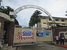
-
 Welcome arch
 -
 Convention Center
 -
 Veterinary Hospital
 -
 City Agriculture Office
 -
 Mural at the old city hall
 -
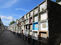 San Jose del Monte Public Cemetery
 -

-
 Mother of Perpetual Help Quasi-Parish in Gaya-gaya
 -
 Altaraza


Notable personalities
- Angeli Tabaquero
- Angelito Sarmiento
- Arthur Robes
- Crispin Beltran
- Chesster Chay
- Eduardo Roquero
- Imelda Papin
References
- ^ City of San Jose del Monte | (DILG)
- ^ "2015 Census of Population, Report No. 3 – Population, Land Area, and Population Density" (PDF). Philippine Statistics Authority. Quezon City, Philippines. August 2016. ISSN 0117-1453. Archived (PDF) from the original on May 25, 2021. Retrieved July 16, 2021.
- ^ a b c Census of Population (2020). "Region III (Central Luzon)". Total Population by Province, City, Municipality and Barangay. Philippine Statistics Authority. Retrieved July 8, 2021.
- ^ "PSA Releases the 2018 Municipal and City Level Poverty Estimates". Philippine Statistics Authority. December 15, 2021. Retrieved January 22, 2022.
- ^ Patinio, Ferdinand (November 1, 2023). "Bulacan voters reject conversion of SJDM into highly urbanized city". Philippine News Agency. Retrieved November 2, 2023.
- ^ Dino Balabo (August 8, 2013). "San Jose del Monte declares moratorium on relocation projects". The Philippine Star. Archived from the original on September 17, 2016. Retrieved October 13, 2015.
- ^ a b c d "History of San Jose Del Monte". City of San Jose Del Monte, Bulacan, Philippines. Archived from the original on January 15, 2017. Retrieved June 30, 2017.
 This article incorporates text from this source, which is in the public domain.
- ^ Reyes, Carmela (January 24, 1996). "Source of income must for resettled squatters". Manila Standard. Kamahalan Publishing Corp. p. 13. Archived from the original on July 5, 2022. Retrieved July 5, 2022.
- ^ Rivera, Lolita T. (May 28, 1988). "Mayor proclaimed". Manila Standard. Standard Publications, Inc. p. 7.
- ^ a b c Reyes, Carmela (September 12, 2000). "Migrant vote: San Jose del Monte Bulacan's 1st city". Philippine Daily Inquirer. p. A12. Archived from the original on November 2, 2023. Retrieved November 2, 2023 – via Google News Archive.
- ^ Republic Act No. 8797:
- "Republic Act No. 8797". Legislative Digital Resoruces. Senate of the Philippines. Archived from the original on November 10, 2023. Retrieved November 2, 2023.
- Republic Act No. 8797 (July 15, 2000). Charter of the City of San Jose del Monte. Archived from the original on July 28, 2023. Retrieved July 28, 2023.
{cite book}: CS1 maint: numeric names: authors list (link)
- ^ Gamos, Ben (October 12, 2002). "Comelec rules Malolos a city". Manila Standard. p. B14. Archived from the original on November 4, 2023. Retrieved November 2, 2023 – via Google Books.
- ^ Republic Act No. 9230 (December 18, 2003). An act amending Section 10 (B) and Sec. 58 of Republic Act No. 8797 (Charter of the City of San Jose del Monte), and providing funds therefor. Archived from the original on November 3, 2023. Retrieved November 2, 2023.
{cite book}: CS1 maint: numeric names: authors list (link) - ^ inquirer.net (December 6, 2020). "Duterte proclaims San Jose del Monte as a highly-urbanized city – Bulacan solon". Archived from the original on December 6, 2020. Retrieved December 6, 2020.
- ^ Presidential Proclamation No. 1057 (December 4, 2020). Conversion of the City of San Jose Del Monte, Bulacan Into a Highly-urbanized City (PDF). Archived (PDF) from the original on June 27, 2021. Retrieved December 5, 2020.
{cite book}:|website=ignored (help)CS1 maint: numeric names: authors list (link) - ^ "Comelec postpones 5 plebiscites to prepare for May 2022 polls". Philippine News Agency. August 19, 2021. Archived from the original on August 24, 2021. Retrieved January 4, 2022.
- ^ "Bulakenyo! Tara na't maging bahagi ng kasaysayan! SAY YES TO HIGHLY URBANIZED CITY OF SAN JOSE DEL MONTE!". Highly Urbanized City of San Jose del Monte. August 14, 2023. Archived from the original on August 30, 2023. Retrieved August 30, 2023.
- ^ Naval, Gerard (September 11, 2023). "San Jose del Monte plebiscite to be held with BSKE – Comelec". Malaya Business Insight. Archived from the original on September 11, 2023. Retrieved September 18, 2023.
- ^ Rita, Joviland (November 1, 2023). "Voters turn down conversion of San Jose del Monte, Bulacan to highly urbanized city". GMA News Online. Archived from the original on November 1, 2023. Retrieved November 1, 2023.
- ^ Cruz, James Patrick (November 1, 2023). "In charts: How Bulacan towns vote on bid to convert San Jose del Monte into highly-urbanized city". Rappler. Archived from the original on November 1, 2023. Retrieved November 1, 2023.
- ^ "San Jose del Monte City Government (Geography)". San Jose del Monte City. Archived from the original on October 22, 2016.
- ^ "San Jose del Monte City Government (Land Use)". San Jose del Monte City. Archived from the original on October 22, 2016.
- ^ "San Jose del Monte: Average Temperatures and Rainfall". Meteoblue. Archived from the original on February 7, 2021. Retrieved May 12, 2020.
- ^ "Plebiscite under way to divide Bulacan's largest village". Inquirer.net. March 25, 2023. Archived from the original on March 25, 2023. Retrieved March 25, 2023.
- ^ Republic Act No. 11896 (July 1, 2022). An Act Dividing Barangay Muzon in the City of San Jose Del Monte, Province of Bulacan Into Four (4) Separate and Independent Barangays to Be Known as Barangay Muzon Proper, Barangay Muzon East, Barangay Muzon West and Barangay Muzon South (PDF). Government of the Philippines. Archived (PDF) from the original on March 18, 2023. Retrieved March 18, 2023.
{cite book}:|website=ignored (help)CS1 maint: numeric names: authors list (link) - ^ Patinio, Ferdinand (January 18, 2023). "Plebiscite for division of Bulacan village set March 25". Philippine News Agency. Archived from the original on March 18, 2023. Retrieved July 28, 2023.
- ^ "Municipal: San Jose del Monte". PSGC Interactive. Quezon City, Philippines: Philippine Statistics Authority. Retrieved January 8, 2016.
- ^ a b Census of Population (2015). "Region III (Central Luzon)". Total Population by Province, City, Municipality and Barangay. Philippine Statistics Authority. Retrieved June 20, 2016.
- ^ Census of Population and Housing (2010). "Region III (Central Luzon)" (PDF). Total Population by Province, City, Municipality and Barangay. National Statistics Office. Retrieved June 29, 2016.
- ^ Censuses of Population (1903–2007). "Region III (Central Luzon)". Table 1. Population Enumerated in Various Censuses by Province/Highly Urbanized City: 1903 to 2007. National Statistics Office.
{cite encyclopedia}: CS1 maint: numeric names: authors list (link) - ^ "Province of Bulacan". Municipality Population Data. Local Water Utilities Administration Research Division. Retrieved December 17, 2016.
- ^ "Population of Region III - Central Luzon (Based on the 2015 Census of Population)". Philippine Statistics Authority. June 1, 2016. Archived from the original on September 15, 2017. Retrieved August 31, 2017.
- ^ "Poverty incidence (PI):". Philippine Statistics Authority. Retrieved December 28, 2020.
- ^ "Estimation of Local Poverty in the Philippines" (PDF). Philippine Statistics Authority. November 29, 2005.
- ^ "2003 City and Municipal Level Poverty Estimates" (PDF). Philippine Statistics Authority. March 23, 2009.
- ^ "City and Municipal Level Poverty Estimates; 2006 and 2009" (PDF). Philippine Statistics Authority. August 3, 2012.
- ^ "2012 Municipal and City Level Poverty Estimates" (PDF). Philippine Statistics Authority. May 31, 2016.
- ^ "Municipal and City Level Small Area Poverty Estimates; 2009, 2012 and 2015". Philippine Statistics Authority. July 10, 2019.
- ^ "PSA Releases the 2018 Municipal and City Level Poverty Estimates". Philippine Statistics Authority. December 15, 2021. Retrieved January 22, 2022.
- ^ "Tourism attractions". gov.ph. Archived from the original on October 16, 2014. Retrieved June 23, 2019.
- ^ Dangla, Demie (June 18, 2015). "Pangarap Village residents decry harassment over land dispute". Manila Today. Archived from the original on February 4, 2018. Retrieved July 22, 2021.
- ^ https://storage.googleapis.com/request-attachments/sHNtR4QrBIFLQ7eBWdLxto4HjnH0jDyVuBC4fK9mENpSfC6TAlwr7qX1GxIcCWjNXvjzRXk6sp62gvDopbTDOCxAuN2Gi8oJpolV/MRT7%20ALIGNMENT.pdf Archived June 29, 2023, at the Wayback Machine[bare URL PDF]
- ^ "About Us". San Jose Water. Archived from the original on July 1, 2023. Retrieved July 28, 2023.
- ^ "DEPED CSJDM". DEPED CSJDM. Archived from the original on August 16, 2019. Retrieved August 16, 2019.
External links
 San Jose del Monte travel guide from Wikivoyage
 Media related to San Jose del Monte at Wikimedia Commons
- Official website
- Philippine Standard Geographic Code
- San Jose del Monte City Bulacan
- Philippine Census Information


| International | |
|---|---|
| National | |
| Geographic | |