Slaná (Semily District)
Slaná | |
|---|---|
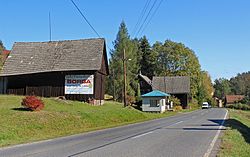 Hořensko, a part of Slaná | |
 Flag  Coat of arms | |
 Slaná Location in the Czech Republic | |
| Coordinates: 50°34′51″N 15°19′47″E / 50.58083°N 15.32972°E | |
| Country | |
| Region | Liberec |
| District | Semily |
| First mentioned | 1430 |
| Area | |
| • Total | 10.26 km2 (3.96 sq mi) |
| Elevation | 358 m (1,175 ft) |
| Population (2023-01-01)[1] | |
| • Total | 675 |
| • Density | 66/km2 (170/sq mi) |
| Time zone | UTC+1 (CET) |
| • Summer (DST) | UTC+2 (CEST) |
| Postal code | 512 01 |
| Website | www |
Slaná is a municipality and village in Semily District in the Liberec Region of the Czech Republic. It has about 700 inhabitants.
Administrative parts
Villages of Bořkov, Hořensko, Nedvězí, Sutice and Světlá are administrative parts of Slaná.
History
The first written mention of Slaná is from 1430.[2]
References
- ^ "Population of Municipalities – 1 January 2023". Czech Statistical Office. 2023-05-23.
- ^ "Historie obce" (in Czech). Obec Slaná. Retrieved 2021-08-20.
Wikimedia Commons has media related to Slaná.
| Authority control databases: National |
|---|