Tarkhankut Peninsula
Tarkhankut Peninsula | |
|---|---|
| Tarkhankutskyi Peninsula | |
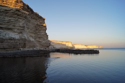 The coastline to the east of Cape Tarkhankut | |
 Tarkhankut Peninsula | |
| Coordinates: 45°25′00″N 32°40′00″E / 45.4167°N 32.6667°E | |
| Location | Crimea |
| Part of | Crimea |
The Tarkhankut Peninsula (Ukrainian: Тарханкутський півострів, Russian: Тарханкутский полуостров, Crimean Tatar: Tarhanqut yarımadası) is the peninsula which constitutes the western extremity of Crimea into the Black Sea. Its northern shore is a southern coast of the Karkinit Bay.[1] Its westernmost point is Cape Prybiynyi; to the south of it is Cape Tarkhankut. The terrain of the peninsula is the Tarkhankut Highlands.
Geography
Cape Tarkhankut
Cape Tarkhankut is a south-western cape of the Peninsula.[2] The Tarkhankut Lighthouse is located on the cape.
Tarkhankut Upland
The Tarkhankut Upland or Tarkhankut Hills is an upland that constitutes the Tarkhankut Peninsula.[3]
The Tarkhankut Wind Farm is located by the Donuzlav lake on the Tarkhankut Upland.[4]
Donuzlav
The Donuzlav Lake (Ukrainian: Донузлав) is a salty lake that is connected to the Black Sea via a ship channel and located at the southern shores of the peninsula.
History
Russo-Ukrainian War
During the Russo-Ukrainian War, the Russian Armed Forces stationed the 3rd Radio Engineering Regiment to the region. The area was also equipped with S-400 missile system for air defense. On August 23, 2023, the Ukrainian military successfully destroyed this missile system through an aerial strike. [5]
See also
References
- ^ Article "Тарханкутский полуостров" in Great Soviet Encyclopedia
- ^ "Мыс Тарханкут (Тархан-Кут) – самая западная точка Крымского полуострова"
- ^ Article "Тарханкутский полуостров" in Great Soviet Encyclopedia
- ^ THE NATIONAL STRATEGY OF UKRAINE FOR JOINT IMPLEMENTATION AND EMISSIONS TRADING PROJECT PIPELINE Kyiv, 2003 (retrieved July 12, 2015)
- ^ "Ukraine wipes out Russian missile system in occupied Crimea". The Kyiv Independent. 2023-08-24. Retrieved 2023-10-30.