Tasman Bridge
Tasman Bridge | |
|---|---|
 | |
| Coordinates | 42°51′54″S 147°20′33″E / 42.86500°S 147.34250°E |
| Carries | Tasman Highway |
| Crosses | River Derwent |
| Locale | Hobart, Tasmania, Australia |
| Maintained by | Department of State Growth |
| Characteristics | |
| Design | Prestressed concrete Girder |
| Total length | 1,395 metres (4,577 ft) |
| Width | 17.5 metres (57 ft) |
| Height | 60.5 metres (198 ft) |
| Longest span | 95 metres (312 ft) |
| Clearance below | 46 metres (151 ft) |
| No. of lanes | 5 |
| History | |
| Constructed by | Reed & Mallik |
| Fabrication by | Braithwaite & Co. |
| Construction start | May 1960 |
| Construction end | 23 December 1964 |
| Opened | 18 August 1964 (2 lanes) 23 December 1964 (4 lanes) 18 March 1965 (official) |
| Statistics | |
| Daily traffic | 73,029 (May 2019)[1] |
| Location | |
 | |
The Tasman Bridge is a bridge that carries the Tasman Highway over the River Derwent in Hobart, Tasmania, Australia. Including approaches, the bridge has a total length of 1,396 metres (4,580 ft) and it provides the main traffic route from the Hobart city centre (on the western shore) to the eastern shore. The bridge has a separated pedestrian footway on each side. There is no dedicated lane for bicycles; however, steps to the pedestrian footway were replaced with ramps in 2010.[2]
History
In the 1950s with the development of the Eastern shore, it was decided to build a larger bridge; the old Hobart Bridge faced increasing difficulty in managing the larger volumes of traffic that came with development, and constantly raising the lift span for shipping was disruptive. In November 1959 Reed & Mallik were awarded a contract to build the bridge.[3]
Construction commenced in May 1960 and the first two lanes bridge opened on 18 August 1964.[4][5] The other two lanes opened on 23 December 1964. It was officially opened on 18 March 1965 by Prince Henry, Duke of Gloucester.
Disaster
On 5 January 1975, the Tasman Bridge was struck by the bulk ore carrier Lake Illawarra, bound for EZ Industries' Risdon Zinc Works with a cargo of 9,072 tonnes (10,000 short tons) of zinc concentrate.[6] It caused two pylons and three sections of concrete decking, totalling 127 metres (417 ft), to fall from the bridge and sink the ship. Seven of the ship's crew were killed, and five motorists died when four cars drove over the collapsed sections before the traffic was stopped. A major press shot showed a Holden Monaro HQ and Holden EK perched balancing on the ledge.[7]
The depth of the river at this point is 35 metres (115 ft). The wreck of Lake Illawarra still lies on the bottom, with concrete slab on top of it, without presenting a navigation hazard to smaller vessels.
The breakage of an important arterial link isolated the residents in Hobart's eastern suburbs – the relatively short drive across the Tasman Bridge to the city suddenly became a 50-kilometre (31 mi) journey via the estuary's next bridge at Bridgewater. The only other vehicular crossing within Hobart after the bridge collapsed was the Risdon Punt, a cable ferry which crossed the river from East Risdon and Risdon, some five kilometres (3.1 mi) upstream from the bridge. It was totally inadequate, carrying only eight cars on each crossing, and although ferries provided a service across the river; it was not until December 1975 that a two lane, 788-metre-long (2,585 ft) bailey bridge was opened to traffic, two kilometres (1.2 mi) to the north from Dowsing Point to Cleburne Point thereby restoring some connectivity.[8] The bailey bridge remained in use until replaced by the Bowen Bridge in 1984.[9]
The separation of Hobart saw an immediate surge in the small and limited ferry service then operating across the river.[6] In a primary position to provide a service were the two ferries of Bob Clifford.[citation needed] He had introduced the locally-built ferries Matthew Brady and James McCabe to the river crossing, from the Hobart city centre to the eastern shore, shortly before the collision. These were soon joined by the MV Cartela, a wooden vessel of 1912 vintage, and Kosciusko, Lady Ferguson and Lady Wakehurst that were loaned by the New South Wales Public Transport Commission.[10][11]
Reconstruction
Reconstruction of the Tasman Bridge by John Holland commenced in October 1975. An important factor of the reconstruction is the improved safety measures. Some examples:
- Large vessels passing beneath the bridge must now do so slightly to the west of the original main navigation span.
- Personnel controlling ships (or harbor pilots) must be trained and then cleared for using the special laser lighthouse that indicates by colours whether the ship must be steered left or right to regain the centre line.
- All road traffic is now halted whilst large vessels transit beneath the bridge.
On top of the new safety measures implemented, the bridge was further upgraded to hold a fifth lane.[6][12][13] This upgrade included the construction of a lane management system which would enable the new middle lane to function as a reversible lane. The system consists of a traffic light system and a sign above each lane, pictured right. The signs, in conjunction with the traffic light system, employ a pulley system to periodically pull the signs over their appropriate lanes.
The middle lane points towards the city side (or western shore) during a.m. peak hours and points back towards the eastern shore during p.m. peak hours. The lane generally points towards the eastern shore during non-peak hours.
The Tasman Bridge repair took two years and cost approximately $44 million.[12] The bridge reopened on 8 October 1977.[6][12][14]
On 20 June 2007, a crane toppled whilst carrying out works on the bridge, and precariously hung for a number of hours off the side of the barriers.[15]
LED upgrade

In 2019 the Hobart City Council commissioned Decrolux to convert the Tasman bridge's fluorescent lighting with modern LED lighting. Spanning almost 3 kilometres (1.9 mi) and utilising 1,930 LEDs, the project was completed in 2021. The lights are remotely programmable and have been used to celebrate Dark Mofo and the Hobart Hurricanes, as well as to show support for causes including Women's Health Week and Men's Health Week.[16]
Gallery

-

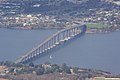
View of the bridge from the eastern shore
-

Looking towards the Tasman Bridge from Montagu Bay
-

Dinghy and the bridge.
-

The repaired bridge span
-
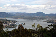
The view of the Bridge from Mount Wellington
-
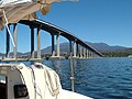
A view of the bridge from the river
-

Tasman Bridge from the Western shore
-

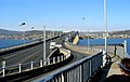
Entering the bridge from the eastern shore
-
Entering the bridge from the west side


See also
References
- ^ Department of State Growth (2019). Department of State Growth Key Arterials Traffic Data Catalogue (PDF). Retrieved 16 August 2022.
- ^ "Cycling South Tasmania – Tasman Hwy and Bridge". 2010. Archived from the original on 29 September 2020. Retrieved 18 July 2013.
- ^ New £4m Bridge for Derwent Canberra Times 28 November 1959 page 3
- ^ Giant Bridge Opened Truck & Bus Transportation September 1964 page 109
- ^ Tasman Bridge Australian Transport October 1964 page 27
- ^ a b c d "Tasmanian Year Book, 2000". Australian Bureau of Statistics. 2002. Retrieved 22 February 2008.
- ^ "Bridge gone". Tasmanian Government. 2000. Archived from the original on 12 April 2020. Retrieved 22 February 2008.
- ^ Hobart's Temporary Bridge Australian Transport April 1976 pages 34/35
- ^ Hobart Electric Traction May 1984 page 93
- ^ New terminals for ferries on three weeks Canberra Times 11 January 1975 page 1
- ^ A Friend in Need Transport News March 1975 page 3
- ^ a b c "Tasman Bridge disaster". Clarence City Council. 2004. Archived from the original on 4 March 2016. Retrieved 22 February 2008.
- ^ "Tasman Bridge Disaster - City of Clarence : City of Clarence". Clarence City Council. Archived from the original on 16 August 2022. Retrieved 16 August 2022.
- ^ The Roads Australian Transport October 1978 page 6
- ^ "Crane drama on Tasman Bridge". The Mercury. 21 June 2007. Archived from the original on 26 June 2007. Retrieved 22 February 2008.
- ^ "Tasman Bridge Lighting Upgrade". decrolux.com.au. Retrieved 8 March 2023.
- Reference: Lewis, Tom. By Derwent Divided. Darwin: Tall Stories, 1999.
- Ludeke, M. (2006) Ten Events Shaping Tasmania's History. Hobart: Ludeke Publishing.
External links
![]() Media related to Tasman Bridge at Wikimedia Commons
Media related to Tasman Bridge at Wikimedia Commons
- Live webcam view of Hobart including the Tasman Bridge
- Traffic camera view of the Tasman Bridge
- Archival photographs of construction of the Tasman Bridge: page 1, page 2.
- 1995 article about Tasman Bridge safety
- Hobart To Tasman Bridge 1938–2000
- Tasman Bridge at Structurae
| Highways | ||
|---|---|---|
| Major roads | ||
| Bridges | ||
| Interchanges | ||
| Proposals | ||
| International | |
|---|---|
| Geographic | |