Telegraph Peak (California)
| Telegraph Peak | |
|---|---|
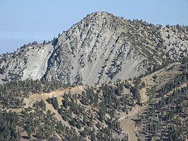 Telegraph Peak as seen from Devils Backbone ridge on Mount San Antonio. | |
| Highest point | |
| Elevation | 8,989 ft (2,740 m) NAVD 88[1] |
| Prominence | 1,183 ft (361 m)[1] |
| Parent peak | Mount San Antonio[2] |
| Listing | Hundred Peaks Section[3] |
| Coordinates | 34°15′41″N 117°35′53″W / 34.2613942°N 117.5981093°W[4] |
| Geography | |
| Location | San Bernardino County, California, U.S. |
| Parent range | San Gabriel Mountains |
| Topo map | USGS Telegraph Peak |
| Climbing | |
| Easiest route | Hike, class 1[3] |
Telegraph Peak, is a peak of the San Gabriel Mountains, in the San Gabriel Mountains National Monument and San Bernardino County, California.
With an elevation of 8,989 feet (2,740 m), it is highest point in the Cucamonga Wilderness of the San Bernardino National Forest.[1]
Most of the bedrock, including that of the summit, is cataclastic gneissGranodiorite underlies much of the southern portion.[5]
See also
References
- ^ a b c "Telegraph Peak, California". Peakbagger.com. Retrieved April 1, 2012.
- ^ "Telegraph Peak". ListsOfJohn.com. Retrieved April 1, 2012.
- ^ a b "Telegraph Peak". Hundred Peaks Section List. Angeles Chapter, Sierra Club. Retrieved August 24, 2009.
- ^ "Telegraph Peak". Geographic Names Information System. United States Geological Survey, United States Department of the Interior. Retrieved August 15, 2007.
- ^ https://ngmdb.usgs.gov/Prodesc/proddesc_71733.htm Dibblee, T.W., and Minch, J.A., 2003. Geologic map of the Telegraph Peak and Phelan quadrangles, San Bernardino County, California