Transport in Georgia (country)
For Soviet transportation, see Transport in the Soviet Union.
Railways


total:
1,683 km in common carrier service; does not include industrial lines
broad gauge:
1,583 km of 1,520 mm (4 ft 11+27⁄32 in) gauge (1993)
narrow gauge:
100 km of 914 mm (3 ft) gauge.
City with metro system: Tbilisi (see Tbilisi Metro).
- In April 2005, an agreement was signed to build a railway from Turkey through Georgia to Azerbaijan (see Kars Baku Tbilisi railway line). The line under construction is using Standard gauge until Akhalkalaki. There will be axle change station for wagons to proceed with broad gauge to Baku.[1]
- In August 2007, Georgia handed over the management rights of the state-owned Georgian Railway company to the U.K.-based company Parkfield Investment for 89 years.[2]
Railway links with adjacent countries
 Russia - yes - 1,520 mm (4 ft 11+27⁄32 in) - via the breakaway Autonomous Republic of Abkhazia - closed for political reasons.
 Azerbaijan - yes - 1,520 mm (4 ft 11+27⁄32 in).
 Armenia - yes 1,520 mm (4 ft 11+27⁄32 in)
 Turkey - yes - break-of-gauge with through 1,435 mm (4 ft 8+1⁄2 in) (Standard Gauge).
2007
- February 7 - agreement signed for Kars-Tbilisi-Baku railway
Towns served by rail
- Poti - port
- Batumi - port
- Kutaisi
- Akhaltsike
Highways
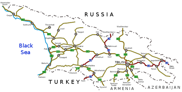
The total length of the road network is approximately 21,000 kilometres (13,000 mi) kilometers (2020[3]), divided over roughly 1,600 kilometres (990 mi) of international trunk roads, 7,000 kilometres (4,300 mi) of domestic main roads and some 12,400 kilometres (7,700 mi) local roads. Only a limited number of kilometers are express roads or motorways which are in good condition. The quality of the other roads varies greatly.


| Number | E Route | name | Length (km) | Notes | |||
|---|---|---|---|---|---|---|---|
| Tbilisi - Senaki - Leselidze | 544 | ||||||
| Senaki - Poti - Sarpi | 119 | ||||||
| Mtskheta - Stepantsminda - Larsi | 139 | ||||||
| Tbilisi - Red Bridge | 57 | ||||||
| Tbilisi – Bakurtsikhe – Lagodekhi | 160 | ||||||
| Ponichala – Marneuli – Guguti | 98 | ||||||
| Marneuli – Sadakhlo | 34 | ||||||
| Khashuri – Akhaltsikhe – Vale | 97 | ||||||
| Tbilisi Bypass | 49 | ||||||
| Gori – Tskhinvali – Gupta – Java – Roki | 92,5 | ||||||
| Akhaltsikhe – Ninotsminda | 112 | ||||||
| Samtredia - Lanchkhuti - Grigoleti | 57 | ||||||
| Akhalkalaki - Kartsakhi | 36,5 | ||||||
| This table is based on the 2017 list of roads of the Government of Georgia.[4] | |||||||
Motorways
Georgia has a limited multilane expressroad/motorway system, that is under development. In 2021 these sections are:
- S1 highway Mukhatgverdi (Tbilisi West) - Surami 113 km (70 mi)
- S1 highway Argveta - Samtredia 58 km (36 mi)
- S4 highway Ponichala (Tbilisi) - Rustavi 9 km (5.6 mi)
- S12 highway Japana - Lanchkhuti 14 km (8.7 mi)
Additionally, the S2 highway has 32 km (20 mi) limited access two-lane freeway (Kobuleti Bypass).
Pipelines
Crude oil 370 km; refined products 300 km; natural gas 440 km (1992)
Ports and harbours
Batumi, Poti, Sokhumi, Kulevi Oil Terminal
Merchant marine
total:
17 ships (with a volume of 1,000 gross tonnage (GT) or over) totaling 103,080 GT/158,803 tonnes deadweight (DWT)
ships by type:
cargo ship 10, chemical tanker 1, petroleum tanker 6 (1999 est.)
Airports


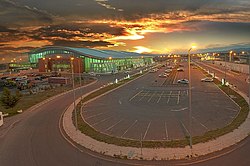
28 (1994 est.) In February 2007 a brand new, modern and fully equipped international Airport was inaugurated in Tbilisi.
- Tbilisi - Shota Rustaveli Airport
- Batumi - Alexander Kartveli Airport
- Kutaisi - David The Builder Airport
- Mestia - Queen Tamar Airport
- Ambrolauri - Ambrolauri Airport
- Poti - Poti International Airport
Airports - with paved runways
total:
14
over 3,047 m:
1
2,438 to 3,047 m:
7
1,524 to 2,437 m:
4
914 to 1,523 m:
1
under 914 m:
1 (1994 est.)
Airports - with unpaved runways
total:
14
over 3,047 m:
1
2,438 to 3,047 m:
1
1,524 to 2,437 m:
1
914 to 1,523 m:
5
under 914 m:
6 (1994 est.)
See also
External links
Notes
- ^ Uysal, Onur. "10 Things to Know About Baku-Tbilisi-Kars Railway Project", Rail Turkey, 20 October 2014
- ^ Georgia Hands over Railway to Investment Fund. Civil Georgia. August 16, 2007.
- ^ "Statistical Yearbook Georgia 2020" (pdf). GeoStat. 2020. p. 200. Archived (PDF) from the original on 2020-12-28. Retrieved 21 December 2021.
- ^ "2017 List of highways of international and domestic importance" (in Georgian). The Legislative Herald of Georgia. 2 November 2017. Retrieved 21 December 2021.
