Věžovatá Pláně
Věžovatá Pláně | |
|---|---|
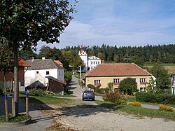 Centre of Věžovatá Pláně | |
 Věžovatá Pláně Location in the Czech Republic | |
| Coordinates: 48°46′35″N 14°24′33″E / 48.77639°N 14.40917°E | |
| Country | |
| Region | South Bohemian |
| District | Český Krumlov |
| First mentioned | 1366 |
| Area | |
| • Total | 4.80 km2 (1.85 sq mi) |
| Elevation | 695 m (2,280 ft) |
| Population (2023-01-01)[1] | |
| • Total | 165 |
| • Density | 34/km2 (89/sq mi) |
| Time zone | UTC+1 (CET) |
| • Summer (DST) | UTC+2 (CEST) |
| Postal code | 382 32 |
| Website | www |
Věžovatá Pláně is a municipality and village in Český Krumlov District in the South Bohemian Region of the Czech Republic. It has about 200 inhabitants.
Věžovatá Pláně lies approximately 9 kilometres (6 mi) south-east of Český Krumlov, 23 km (14 mi) south of České Budějovice, and 146 km (91 mi) south of Prague.
Administrative parts
The village of Dolní Pláně is an administrative part of Věžovatá Pláně.
Demographics
| Year | Pop. | ±% |
|---|---|---|
| 1869 | 218 | — |
| 1880 | 254 | +16.5% |
| 1890 | 256 | +0.8% |
| 1900 | 268 | +4.7% |
| 1910 | 246 | −8.2% |
| 1921 | 214 | −13.0% |
| 1930 | 222 | +3.7% |
| 1950 | 132 | −40.5% |
| 1961 | 169 | +28.0% |
| 1970 | 141 | −16.6% |
| 1980 | 109 | −22.7% |
| 1991 | 99 | −9.2% |
| 2001 | 111 | +12.1% |
| 2011 | 134 | +20.7% |
| 2021 | 159 | +18.7% |
| Source: Censuses[2][3] | ||
References
- ^ "Population of Municipalities – 1 January 2023". Czech Statistical Office. 2023-05-23.
- ^ "Historický lexikon obcí České republiky 1869–2011 – Okres Český Krumlov" (in Czech). Czech Statistical Office. 2015-12-21. pp. 31–32.
- ^ "Population Census 2021: Population by sex". Public Database. Czech Statistical Office. 2021-03-27.
External links
Wikimedia Commons has media related to Věžovatá Pláně.
| Authority control databases: National |
|---|