Záhor
Záhor
Zahar | |
|---|---|
 Flag | |
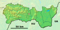 Záhor Location of Záhor in the Košice Region  Záhor Location of Záhor in Slovakia | |
| Coordinates: 48°38′N 22°12′E / 48.63°N 22.20°E | |
| Country | |
| Region | |
| District | Sobrance District |
| First mentioned | 1326 |
| Area | |
• Total | 7.70 km2 (2.97 sq mi) |
| Elevation | 109 m (358 ft) |
| Population (2021)[3] | |
• Total | 639 |
| Time zone | UTC+1 (CET) |
| • Summer (DST) | UTC+2 (CEST) |
| Postal code | 725 3[2] |
| Area code | +421 56[2] |
| Car plate | SO |
| Website | www |
Záhor (Hungarian: Zahar) is a village and municipality in the Sobrance District in the Košice Region of east Slovakia.
History
In historical records the village was first mentioned in 1326.
Geography
The village lies at an altitude of 109 metres and covers an area of 7.722 km2. It has a population of 710 people.
Facilities
The village has a soccer pitch.
References
- ^ "Hustota obyvateľstva - obce [om7014rr_ukaz: Rozloha (Štvorcový meter)]". www.statistics.sk (in Slovak). Statistical Office of the Slovak Republic. 31 March 2022. Retrieved 31 March 2022.
- ^ a b c "Základná charakteristika". www.statistics.sk (in Slovak). Statistical Office of the Slovak Republic. 17 April 2015. Retrieved 31 March 2022.
- ^ "Počet obyvateľov podľa pohlavia - obce (ročne)". www.statistics.sk (in Slovak). Statistical Office of the Slovak Republic. 31 March 2022. Retrieved 31 March 2022.