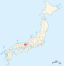
ولایت تانبا
نقشه ژاپن در سال ۱۸۶۸ میلادی. این ولایت با رنگ تیره مشخص شدهاست.
ولایت تانبا (به ژاپنی : 丹波国 Tanba no kuni ) یکی از ولایتها در تقسیمبندی کشوری قدیم ژاپن بود. این ولایت امروزه با قسمت مرکزی استان کیوتو ، شمال شرقی استان هیوگو و قسمت شمالی استان اوساکا منطبق است.
منابع
پیوند به بیرون
Kinai Tōkaidō Tōsandō Hokurikudō San'indō San'yōdō Nankaidō Saikaidō هوکایدو 1869- Pre-Taihō Code provinces
Chichibu
Fusa
Hi
Keno
Kibi
Koshi
Kumaso
Toyo
Tsukushi
Source : Nussbaum, Louis-Frédéric. (2005). "Provinces and prefectures" in
Japan Encyclopedia, p. 780 , p. 780, در
گوگل بوکس ; excerpt,
"Japan's former provinces were converted into استانهای ژاپن by the Meiji government ... [and] grouped, according to geographic position, into the 'five provinces of the Kinai' and 'seven circuits'."
The article is a derivative under the Creative Commons Attribution-ShareAlike License .
A link to the original article can be found here and attribution parties here
By using this site, you agree to the Terms of Use . Gpedia ® is a registered trademark of the Cyberajah Pty Ltd