یئوویل
منطقه مسکونی در England
| Yeovil |
|---|
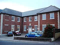
Yeovil County Court |
| جمعیت | ۴۰٬۰۰۰ [۱] |
|---|
| مرجع شبکه OS | ST552164
|
|---|
| منطقه | |
|---|
| Shire county | |
|---|
| ناحیه | |
|---|
| کشور | England |
|---|
| کشور مستقل | بریتانیا |
|---|
| پست شهر | YEOVIL |
|---|
| کدپستی منطقه | BA20, BA21, BA22 |
|---|
| کد تلفن | 01935 |
|---|
|
| پلیس | Avon and Somerset |
|---|
| آتشنشانی | Devon and Somerset |
|---|
| آمبولانس | South Western |
|---|
|
|
| مجلس انگلستان | |
|---|
- فهرست مکانها
- بریتانیا
- انگلستان
- Somerset
|
latitudeیئوویلlongitudeیئوویل
یئوویل (به انگلیسی: Yeovil) یک منطقهٔ مسکونی در انگلستان است که در جنوب غربی انگلستان واقع شدهاست.[۲]
خصوصیات
یئوویل ۴۰٬۰۰۰ نفر جمعیت دارد.
جستارهای وابسته
منابع
|
|---|
| خودمختار | |
|---|
| بورگها و مناطق | |
|---|
| اقامتگاههای اصلی | |
|---|
| رودها |
- Alham
- Aller
- Avill
- Avon
- Axe (Bristol Channel)
- Axe (Lyme Bay)
- Badgworthy Water
- Banwell
- Barle
- Brue
- Cam Brook
- Cary
- Chew
- رود ایست لین
- Exe
- Fivehead
- Frome
- رود هادو
- Hoar Oak Water
- Holford
- Horner
- Huntspill
- Isle
- Land Yeo
- Mells
- Midford Brook
- Oare Water
- Parret
- Severn Estuary
- Sheppey
- Somer
- Sowy
- Tone
- Washford
- Wellow Brook
- West Lyn
- Whitelake
- Yeo (Congresbury)
- Yeo (South Somerset)
|
|---|
| موضوعات |
- Country houses
- County Council
- Culture of Somerset
- Economy of Somerset
- پرچم شهرستان سامرست
- Geography of Somerset
- Geology of Somerset
- Grade I listed buildings
- Grade II* listed buildings
- High Sheriff of Somerset
- History of Somerset
- Local nature reserves
- Lord Lieutenant of Somerset
- Museums
- National nature reserves
- Parliamentary constituencies
- Places
- Scheduled monuments
- Schools
- SSSIs
- Transport in Somerset
Geographic areas: Blackdown Hills
- Brendon Hills
- Chew Valley
- Exmoor
- Mendip Hills
- Polden Hills
- Quantock Hills
- Somerset Levels
- South West Coast Path
- West Somerset Coast Path
|
|---|

