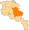
Getik (Gegharkunik)
| Getik (hy) Գետիկ | ||||
 Sanctuaire d'État Getik | ||||
| Administration | ||||
|---|---|---|---|---|
| Pays | ||||
| Région | Gegharkunik | |||
| Démographie | ||||
| Population | 491 hab. (2008) | |||
| Densité | 29 hab./km2 | |||
| Géographie | ||||
| Coordonnées | 40° 39′ 44″ nord, 45° 16′ 00″ est | |||
| Altitude | 1 820 m |
|||
| Superficie | 1 716 ha = 17,16 km2 | |||
| Fuseau horaire | UTC+4 | |||
| Localisation | ||||
| Géolocalisation sur la carte : Arménie
Géolocalisation sur la carte : Arménie
Géolocalisation sur la carte : Gegharkunik
| ||||
| modifier |
||||
Getik (en arménien Գետիկ ; anciennement Nor Bashgyugh[1]) est une communauté rurale du marz de Gegharkunik, en Arménie. Fondée en 1922[1], elle compte 491 habitants en 2008[2].
Notes et références
- (en) John Brady Kiesling, Rediscovering Armenia : An Archaeological/Touristic Gazetteer and Map Set for the Historical Monuments of Armenia, Erevan, , 71 p. (lire en ligne), p. 49.
- ↑ (en) ArmStat, Marzes of the Republic of Armenia in figures, 2008, « RA Gegharkunik Marz », (consulté le ).


