Hohenberg (Basse-Autriche)
Pour les articles homonymes, voir Hohenberg.
Cet article est une ébauche concernant une localité autrichienne.
Vous pouvez partager vos connaissances en l’améliorant (comment ?) selon les recommandations des projets correspondants.
| Hohenberg | ||||
 Héraldique |
||||

| ||||
| Administration | ||||
|---|---|---|---|---|
| Pays | ||||
| Land | ||||
| District (Bezirk) |
Lilienfeld | |||
| Code postal | A- | |||
| Immatriculation | LF | |||
| Indicatif | 43+ | |||
| Démographie | ||||
| Population | 1 515 hab. ([1],[2]) | |||
| Densité | 27 hab./km2 | |||
| Géographie | ||||
| Coordonnées | 47° 54′ 00″ nord, 15° 37′ 00″ est | |||
| Altitude | 488 m |
|||
| Superficie | 5 662 ha = 56,62 km2 | |||
| Localisation | ||||
| Géolocalisation sur la carte : Autriche
Géolocalisation sur la carte : Autriche
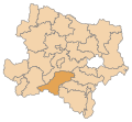
Géolocalisation sur la carte : Basse-Autriche
| ||||
| modifier |
||||


Hohenberg est une commune autrichienne du district de Lilienfeld en Basse-Autriche.
Géographie
Cette section est vide, insuffisamment détaillée ou incomplète. Votre aide est la bienvenue ! Comment faire ?
Histoire
Cette section est vide, insuffisamment détaillée ou incomplète. Votre aide est la bienvenue ! Comment faire ?
Liens externes
Aperçu des références
- ↑ Bevölkerung zu Jahresbeginn nach Gemeinden seit 2002 (statistique publique), Statistik Austria, , [lire en ligne].
- ↑ « Einwohnerzahl 1.1.2018 nach Gemeinden mit Status, Gebietsstand 1.1.2018 », Statistik Austria (en) (consulté le )