Oroslavje
| Oroslavje | ||||
 Héraldique |
||||

| ||||
| Administration | ||||
|---|---|---|---|---|
| Pays | ||||
| Comitat | Krapina-Zagorje | |||
| Maire Mandat |
Ivan Tuđa 2005-2009 |
|||
| Code postal | 49243 | |||
| Indicatif téléphonique international | +(385) | |||
| Indicatif téléphonique local | 049 | |||
| Démographie | ||||
| Population | 3 420 hab. (2001) | |||
| Densité | 107 hab./km2 | |||
| Population municipalité | 6 253 hab. (2001) | |||
| Densité | 195 hab./km2 | |||
| Géographie | ||||
| Coordonnées | 46° 01′ 40″ nord, 15° 54′ 41″ est | |||
| Altitude | 200 m |
|||
| Superficie | 3 200 ha = 32 km2 | |||
| Superficie municipalité | 3 200 ha = 32 km2 | |||
| Localisation | ||||
| Géolocalisation sur la carte : Croatie
Géolocalisation sur la carte : Croatie
Géolocalisation sur la carte : comitat de Krapina-Zagorje
| ||||
| Liens | ||||
| Site web | www.oroslavje.hr | |||
| modifier |
||||
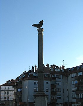
Oroslavje est une ville et une municipalité située dans le comitat de Krapina-Zagorje, en Croatie. Au recensement de 2001, la municipalité comptait 98,26 habitants, dont 98,26 % de Croates[1] et la ville seule comptait 3 420 habitants[2].
Histoire
Localités
La municipalité de Oroslavje compte 5 localités :
- Andraševec
- Krušljevo Selo
- Mokrice
- Oroslavje
- Stubička Slatina
Notes et références
- (en) Recensement de 2001 : « Population by ethnicity, by towns/municipalities, census 2001 », sur dzs.hr, Crostat - Bureau central de statistiques (consulté le )
- (en) « Population by sex and age by settlements, census 2001 », sur dzs.hr, Crostat - Bureau central de statistiques (consulté le )


