न्यूज़ीलैण्ड
| न्यूज़ीलैंड Aotearoa (Maori) |
||||||
|---|---|---|---|---|---|---|
|
||||||
राष्ट्रीय गान:
|
||||||
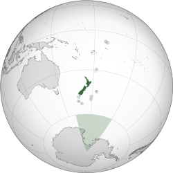 Location of New Zealand, including outlying islands, its territorial claim in the Antarctic, and Tokelau
|
||||||
| राजधानी | वेलिंगटन | |||||
| सबसे बड़ा नगर | ऑकलैंड | |||||
| राजभाषा(एँ) |
|
|||||
| मानवजातीय वर्ग (2013) |
|
|||||
| निवासी | न्यूज़ीलैंडर कीवी (अनौपचारिक) |
|||||
| सरकार | एकात्मक संसदीय संवैधानिक राजतंत्र | |||||
| - | राजशाही | चार्ल्स तृतीय | ||||
| - | महाराज्यपाल | डेम अलसियॉन सिंथिया किरो | ||||
| - | प्रधान मंत्री | जैसिंडा अर्डर्न | ||||
| विधान मण्डल | संसद (प्रतिनिधि सभा) |
|||||
| स्वतंत्रता के चरण from the संयुक्त राजशाही | ||||||
| - | उत्तरदायी शासन | 7 मई 1856 | ||||
| - | न्यूज़ीलैंड | 26 सितम्बर 1907 | ||||
| - | Statute of Westminster adopted | 25 नवंबर 1947 | ||||
| क्षेत्रफल | ||||||
| - | कुल | 268,021 km2 (75वां) | ||||
| - | जल (%) | 1.6[n 4] | ||||
| जनसंख्या | ||||||
| - | मार्च 2024 जनगणना | साँचा:Poptoday[5] (120th) | ||||
| - | 2013 जनगणना | 4,242,048 | ||||
| सकल घरेलू उत्पाद (पीपीपी) | 2018 प्राक्कलन | |||||
| - | कुल | $199 billion[6] | ||||
| - | प्रति व्यक्ति | $40,266[6] | ||||
| सकल घरेलू उत्पाद (सांकेतिक) | 2018 प्राक्कलन | |||||
| - | कुल | $206 billion[6] | ||||
| - | प्रति व्यक्ति | $41,616[6] | ||||
| गिनी (2014) | 33.0[7] मध्यम · 22nd |
|||||
| मानव विकास सूचकांक (2017) | बहुत उच्च · 16th |
|||||
| मुद्रा | New Zealand dollar ($) (NZD) | |||||
| समय मण्डल | NZST[n 5] (यू॰टी॰सी॰+12) | |||||
| - | ग्रीष्मकालीन (दि॰ब॰स॰) | NZDT[n 6] (यू॰टी॰सी॰+13) | ||||
| दिनांक प्रारूप | dd/mm/yyyy | |||||
| यातायात चालन दिशा | left | |||||
| दूरभाष कूट | +64 | |||||
| ISO 3166 code | NZ | |||||
| इंटरनेट टीएलडी | .nz | |||||

न्यूज़ीलैंड प्रशान्त महासागर में ऑस्ट्रेलिया के पास स्थित देश है। ये दो बड़े द्वीपों से बना है।
न्यूज़ीलैंड (माओरी भाषा में: आऔतैआरौआ) दक्षिण पश्चिमि प्रशांत महासागर में दो बड़े द्वीप और अन्य कई छोटे द्वीपों से बना एक देश है।
न्यूज़ीलैंड के ४० लाख लोगों में से लगभग तीस लाख लोग उत्तरी द्वीप में रहते हैं और दस लाख लोग दक्षिणी द्वीप में। यह द्वीप दुनिया के सबसे बडे द्वीपों में गिने जाते हैं। अन्य द्वीपों में बहुत कम लोग रहतें हैं और वे बहुत छोटे हैं। इनमें मुख्य है:
- स्टिवोट द्वीप (दक्षिण द्वीप के दक्षिण में स्थित), तीसरा सबसे बड़ा द्वीप, जनसन्ख्या ४००
इतिहास
मुख्य लेख: न्यूजीलैंड का इतिहास'
राजनीती
न्यूजीलैंड में सरकार एकात्मक संसदीय संवैधानिक राजतंत्र प्रणाली के अधीन है व् इस देश की सरकार महारानी एलिजाबेथ द्वितीय द्वारा शासित है, लेकिन इस देश में चुनाव होते है व् न्यूजीलैंड को चुनाव के द्वारा अपना प्राइम मिनिस्टर चुनने का अधिकार है.
भूगोल
दक्षिण पश्चिमी प्रशांत महासागर में स्थित एक खूबसूरत द्वीप देश है, जोकि प्रशांत महासागर में ऑस्ट्रेलिया के पूर्व में स्थित है. इस द्वीप की भौगोलिक स्थिति बेहद लाजवाब है व इसके दक्षिण में नई कैलेडोनिया, टोंगा और फिजी देश स्थित हैं।
न्यूजीलैंड कई द्वीपों के समूह से बना देश है, जिसमें उत्तर और दक्षिण द्वीप सबसे बड़े और सबसे अधिक आबादी वाले द्वीप शामिल है, साथ ही इसके इस द्वीप का वातावरण व सुहावना मौसम विश्व भर के सैलानियों को अपनी और आकर्षित करता है।
सन्दर्भ
- ↑ "Protocol for using New Zealand's National Anthems". Ministry for Culture and Heritage. मूल से 11 मई 2011 को पुरालेखित. अभिगमन तिथि 17 February 2008.
- ↑ New Zealand Government (21 December 2007) International Covenant on Civil and Political Rights Fifth Periodic Report of the Government of New Zealand, पृ॰ 89. (Report). Retrieved 18 November 2015. "In addition to the Māori language, New Zealand Sign Language is also an official language of New Zealand. The New Zealand Sign Language Act 2006 permits the use of NZSL in legal proceedings, facilitates competency standards for its interpretation and guides government departments in its promotion and use. English, the medium for teaching and learning in most schools, is a de facto official language by virtue of its widespread use. For these reasons, these three languages have special mention in the New Zealand Curriculum." Archived 2015-01-24 at the वेबैक मशीन
- ↑ सन्दर्भ चेतावनी:
<ref>टैग काQuickStats_ethnicityनाम के साथ पूर्वावलोकन नहीं किया जा सका क्योंकि या तो यह वर्तमान विभाग के बाहर परिभाषित है अथवा परिभाषित ही नहीं है। - ↑ "The New Zealand Land Cover Database". New Zealand Land Cover Database 2. Ministry for the Environment. 1 July 2009. मूल से 14 मार्च 2011 को पुरालेखित. अभिगमन तिथि 26 April 2011.
- ↑ "Population clock". Statistics New Zealand. मूल से 12 जुलाई 2017 को पुरालेखित. अभिगमन तिथि 14 April 2016. The population estimate shown is automatically calculated daily at 00:00 UTC and is based on data obtained from the population clock on the date shown in the citation.
- ↑ अ आ इ ई "New Zealand". International Monetary Fund. अभिगमन तिथि 9 October 2018.
- ↑ "Income inequality". Statistics New Zealand. मूल से 15 जून 2015 को पुरालेखित. अभिगमन तिथि 14 June 2015.
- ↑ "Human Development Report 2018" (PDF). HDRO (Human Development Report Office) United Nations Development Programme. पृ॰ 22. मूल (PDF) से 22 मार्च 2017 को पुरालेखित. अभिगमन तिथि 14 September 2018.
- ↑ "New Zealand Daylight Time Order 2007 (SR 2007/185)" (अंग्रेज़ी में). New Zealand Parliamentary Counsel Office. 6 July 2007. मूल से 7 मार्च 2017 को पुरालेखित. अभिगमन तिथि 6 March 2017.
बाहरी कड़ियाँ
सन्दर्भ की झलक
- ↑ "God Save the king" is officially a national anthem but is generally used only on regal and viceregal occasions.[1]
- ↑ English is a de facto official language due to its widespread use.[2]
- ↑ Ethnicity figures add to more than 100% as people could choose more than one ethnic group.
- ↑ The proportion of New Zealand's area (excluding estuaries) covered by rivers, lakes and ponds, based on figures from the New Zealand Land Cover Database,[4] is (357526 + 81936) / (26821559 – 92499–26033 – 19216) = 1.6%. If estuarine open water, mangroves, and herbaceous saline vegetation are included, the figure is 2.2%.
- ↑ The Chatham Islands have a separate time zone, 45 minutes ahead of the rest of New Zealand.
- ↑ Clocks are advanced by an hour from the last Sunday in September until the first Sunday in April.[9] Daylight saving time is also observed in the Chatham Islands, an additional 45 minutes ahead.