Southern Rivers
 Peta lokasi
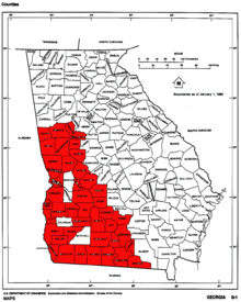
Southern Rivers adalah sebuah wilayah region di sebelah barat laut negara bagian Georgia, Amerika Serikat.
Geografi
Region Southern Rivers terdiri atas county-county berikut:
- Baker
- Berrien
- Brooks
- Chattahoochee
- Clay
- Colquitt
- Cook
- Coweta
- Crisp
- Decatur
- Dooly
- Dougherty
- Early
- Echols
- Fayette
- Grady
- Harris
- Heard
- Irwin
- Lanier
- Lee
- Lowndes
- Macon
- Meriwether
- Miller
- Muscogee
- Pike
- Quitman
- Randolph
- Schley
- Seminole
- Spalding
- Stewart
- Sumter
- Talbot
- Taylor
- Terrell
- Thomas
- Tift
- Troup
- Turner
- Upson
- Worth
|
|---|
|
| Topik |
- Geology
- History
- Government
- Governors
- Culture
- People
- Music
- Politics
- Geography
- State Parks
- Demographics
- Economy
- Sports
- Visitor Attractions
|
|---|
| Wilayah |
- Atlantic Coastal Plain
- Blue Ridge
- Colonial Coast
- Cumberland Plateau
- The Golden Isles
- Historic South
- Inland Empire
- Metro Atlanta
- Middle Georgia
- North Georgia Mountains
- Piedmont
- Ridge and Valley
- Sea Islands
- Southern Rivers
- Tennessee Valley
- Wiregrass Region
|
|---|
| Kota besar | |
|---|
| County | |
|---|
