Template:Infobox Islands
| 地理 | |
|---|---|
| 行政 |
このテンプレートは{Infobox 島}と同様、島や列島の基礎情報を表示するテンプレートです。英語版と完全互換となっており、英語版からの転記に役立ちます。{Infobox 島}より項目が多くなっています。
使用テキスト
| [[{native name link}|現地名]]: {native name} 愛称: {sobriquet} | |
|---|---|
|
[[File:{image name}|{image size}|alt={image alt}|{image alt}]] {image caption} | |
| 名の由来 | {etymology} |
| 地理 | |
| 場所 | {location} |
| 座標 | 北緯0° 東経0° / 北緯0度 東経0度座標: 北緯0° 東経0° / 北緯0度 東経0度 |
| 英式座標 | {GridReference} |
| 諸島 | {archipelago} |
| 隣接水域 | {waterbody} |
| 島数 | {total islands} |
| 主要な島 | {major islands} |
| 面積順位 | {rank} |
| 最高峰 | {highest mount} |
| 行政 | |
|
{country} | |
| {country admin divisions title} | {country admin divisions} |
| {country admin divisions title 1} | {country admin divisions 1} |
| {country admin divisions title 2} | {country admin divisions 2} |
| 首都 | {country capital} |
| 最大都市 | {country largest city}(人口{country largest city population}) |
| {country leader title} | {country leader name} |
| 面積 | {country area km2} or {country area sqmi} or {country area m2} or {country area sqft} or {country area ha} or {country area acre} |
|
{country 1} | |
| {country 1 admin divisions title} | {country 1 admin divisions} |
| {country 1 admin divisions title 1} | {country 1 admin divisions 1} |
| 首都 | {country 1 capital} |
| 最大都市 | {country 1 largest city}(人口{country 1 largest city population}) |
| {country 1 leader title} | {country 1 leader name} |
| 面積 | {country 1 area km2} or {country 1 area sqmi} or {country 1 area m2} or {country 1 area sqft} or {country 1 area ha} or {country 1 area acre} |
|
{country 2} | |
| {country 2 admin divisions title} | {country 2 admin divisions} |
| {country 2 admin divisions title 1} | {country 2 admin divisions 1} |
| 首都 | {country 2 capital} |
| 最大都市 | {country 2 largest city}(人口{country 2 largest city population}) |
| {country 2 leader title} | {country 2 leader name} |
| 面積 | {country 2 area km2} or {country 2 area sqmi} or {country 2 area m2} or {country 2 area sqft} or {country 2 area ha} or {country 2 area acre} |
| 人口統計 | |
| 住民の呼称 | {demonym} |
| 人口 | {population}({population as of}年時点) |
| 人口順位 | {population rank} 最高位{population rank max} |
| 人口密度順位 | {density rank} |
| 言語 | {languages} |
| 民族 | {ethnic groups} |
| 追加情報 | |
| 時間帯 |
|
| • 夏時間(DST) |
|
| 公式サイト | {website} |
| {additional info} | |
メートル法単位
{Infobox Islands
| name             = <!-- mandatory -->
| native name      = <!-- or |local name= -->
| native name link =
| native_name_lang =
| sobriquet        = <!-- or |nickname= -->
| image name       =
| image size       =
| image caption    =
| image alt        =
| map              =
| map_alt          =
| map_width        =
| map_caption      =
| map_relief       =
| label            =
| label_position   =
| coordinates      = <!-- {coord|display=it} -->
| etymology        =
| location         = <!-- mandatory, body of water where located -->
| GridReference    = <!-- UK only -->
| archipelago      =
| waterbody        =
| total islands    =
| major islands    =
| area km2         = <!-- or |area m2= or |area ha= -->
| area footnotes   =
| rank             =
| length km        = <!-- or |length m=  -->
| length footnotes =
| width km         = <!-- or |width m=  -->
| width footnotes  =
| coastline km     = <!-- or |coastline m=  -->
| coastline footnotes =
| elevation m      =
| elevation footnotes =
| highest mount    =
| country          = <!-- mandatory -->
| country admin divisions title      =
| country admin divisions            =
| country admin divisions title 1    =
| country admin divisions 1          =
| country admin divisions title 2    =
| country admin divisions 2          =
| country capital type               =
| country capital                    =
| country largest city type          =
| country largest city               =
| country capital and largest city   =
| country largest city population    =
| country leader title               =
| country leader name                =
| country area km2                   = <!-- or |country area m2= or |country area ha= -->
| country 1                          =
| country 1 admin divisions title    =
| country 1 admin divisions          =
| country 1 admin divisions title 1  =
| country 1 admin divisions 1        =
| country 1 capital type             =
| country 1 capital                  =
| country 1 largest city type        =
| country 1 largest city             =
| country 1 capital and largest city =
| country 1 largest city population  =
| country 1 leader title             =
| country 1 leader name              =
| country 1 area km2                 = <!-- or |country 1 area m2= or |country 1 area ha= -->
| demonym          =
| population       =
| population as of =
| population footnotes =
| population rank =
| population rank max =
| density km2      =
| density rank     =
| density footnotes =
| languages        =
| ethnic groups    =
| timezone1        =
| utc_offset1      =
| timezone1_DST    =
| utc_offset1_DST  =
| website          =
| additional info  =
}
非メートル法単位
{Infobox Islands
| name             = <!-- mandatory -->
| native name      = <!-- or |local name= -->
| native name link =
| native_name_lang =
| sobriquet        = <!-- or |nickname= -->
| image name       =
| image size       =
| image caption    =
| image alt        =
| map              =
| map_alt          =
| map_width        =
| map_caption      =
| map_relief       =
| label            =
| label_position   =
| coordinates      = <!-- {coord|LATITUDE|N/S|LONGITUDE|E/W|display=it} -->
| etymology        =
| location         = <!-- mandatory, body of water where located -->
| GridReference    = <!-- UK only -->
| archipelago      =
| waterbody        =
| total islands    =
| major islands    =
| area sqmi        = <!-- or |area sqft= or |area acre= -->
| area footnotes   =
| rank             =
| length mi        = <!-- or |length ft= -->
| length footnotes =
| width mi         = <!-- or |width ft= -->
| width footnotes  =
| coastline mi     = <!-- or |coastline ft= -->
| coastline footnotes =
| elevation ft     =
| elevation footnotes =
| highest mount    =
| country          = <!-- mandatory -->
| country admin divisions title      =
| country admin divisions            =
| country admin divisions title 1    =
| country admin divisions 1          =
| country admin divisions title 2    =
| country admin divisions 2          =
| country capital type               =
| country capital                    =
| country largest city type          =
| country largest city               =
| country capital and largest city   =
| country largest city population    =
| country leader title               =
| country leader name                =
| country area sqmi                  = <!-- or |country area sqft= or |country area acre= -->
| country 1                          =
| country 1 admin divisions title    =
| country 1 admin divisions          =
| country 1 admin divisions title 1  =
| country 1 admin divisions 1        =
| country 1 capital type             =
| country 1 capital                  =
| country 1 largest city type        =
| country 1 largest city             =
| country 1 capital and largest city =
| country 1 largest city population  =
| country 1 leader title             =
| country 1 leader name              =
| country 1 area sqmi                = <!-- or |country 1 area sqft= or |country 1 area acre= -->
| demonym          =
| population       =
| population as of =
| population footnotes =
| population rank =
| population rank max =
| density sqmi     =
| density rank     =
| density footnotes =
| ethnic groups    =
| timezone1        =
| utc_offset1      =
| timezone1_DST    =
| utc_offset1_DST  =
| website          =
| additional info  =
}
使用例
| 現地名: Pulau Sumatra | |
|---|---|
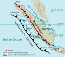 スマトラ島のテクトニクス | |
| 地理 | |
| 場所 | 東南アジア |
| 座標 | 北緯0度 東経102度 / 北緯0度 東経102度 |
| 諸島 | 大スンダ列島 |
| 面積 | 470,000 km2 (180,000 sq mi) |
| 行政 | |
|
インドネシア | |
| 州 | アチェ州、北スマトラ州、西スマトラ州、ブンクル州、ジャンビ州、南スマトラ州、リアウ州、ランプン州 |
| 人口統計 | |
| 住民の呼称 | スマトラン |
| 人口 | 4000万人以上 |
| 人口密度 | 85 /km2 (220 /sq mi) |
| 民族 | アチェ人、バタック人、ミナンカバウ人、マレー人 |
{Infobox Islands
| name          = スマトラ島
| native name   = Pulau Sumatra
| native name link = インドネシア語
| image name    = Sumatra Volcanoes.png
| image caption = スマトラ島のテクトニクス
| image alt     = The island of Sumatra, oriented northwest-southeast, with a line of volcanoes along its southwestern edge, and the offshore Sumatra Trench encroaching on it at a rate of 5.5 centimetres per year.
| area km2      = 470000
| location      = [[東南アジア]]
| coordinates   = {coord|0|N|102|E|region:ID|display=inline}
| archipelago   = [[大スンダ列島]]
| country       = インドネシア
| country admin divisions title = 州
| country admin divisions       = [[アチェ州]]、[[北スマトラ州]]、[[西スマトラ州]]、[[ブンクル州]]、[[ジャンビ州]]、[[南スマトラ州]]、[[リアウ州]]、[[ランプン州]]
| largest city  = [[メダン]]
| demonym       = スマトラン
| population    = 4000万人以上
| density km2   = 85
| ethnic groups = [[アチェ人]]、[[バタック人]]、[[ミナンカバウ人]]、[[マレー人]]
}
内部テンプレート
このテンプレートには下記の内部テンプレートがあります。
関連項目
- Template:Infobox 島
- Category:島
- Wikipedia:緯度・経度の調べ方 - 座標の調査方法を解説したページ。
説明はありません。
| パラメーター | 説明 | 型 | 状態 | |||
|---|---|---|---|---|---|---|
| パラメーターが指定されていません | ||||||